TopoQuest Logo
Do you find TopoQuest useful?
Help keep TopoQuest running and adding new maps/features by donating!
Bitcoin:  19c7KJd3qBynnjoSw5npx9KScwjBe4ifkT
Litecoin:  LXs6TkuXGGXo1vDsWCkWVdjQX94eUKd6ui
Home View Maps Find Maps Find Places Resources & Links


Friedensburg, Pennsylvania Topographic Map

USGS Map Title: Friedensburg, PA
USGS Map MRC: 40076E2
DRG (GeoTIFF) Download: o40076e2.tif


Neighboring USGS Topographic Map Quads:


  Minersville, PA  
40076F3
 

  Pottsville, PA  
40076F2
 

  Orwigsburg, PA  
40076F1
 

  Swatara Hill, PA  
40076E3
 

  Friedensburg, PA  
40076E2
 

  Auburn, PA  
40076E1
 

  Bethel, PA  
40076D3
 

  Strausstown, PA  
40076D2
 

  Bernville, PA  
40076D1


Map MRC Location:

N41°
W77°
N41°
W76°
H8 H7 H6 H5 H4 H3 H2 H1
G8 G7 G6 G5 G4 G3 G2 G1
F8 F7 F6 F5 F4 F3 F2 F1
E8 E7 E6 E5 E4 E3 E2 E1
D8 D7 D6 D5 D4 D3 D2 D1
C8 C7 C6 C5 C4 C3 C2 C1
B8 B7 B6 B5 B4 B3 B2 B1
A8 A7 A6 A5 A4 A3 A2 A1
N40°
W77°
N40°
W76°

Friedensburg, PA USGS 1:24K Topographic Map Preview:
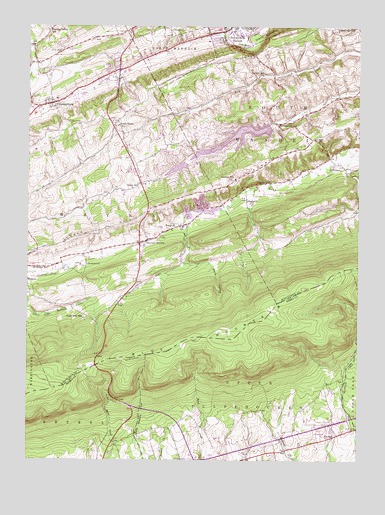
Friedensburg, PA USGS Topographic Map
Click on map above to begin viewing in our Map Viewer.

This topographic map contains these locations and features:
Feature Name Type Latitude Longitude GNIS ID View Map
AucheysPopulated PlaceN40.5751°W76.1663°1202998View Map
Aucheys SchoolSchoolN40.5804°W76.1580°1168501View Map
Black Horse SchoolSchoolN40.5970°W76.2152°1169712View Map
Blue Mountain West Elementary SchoolSchoolN40.6043°W76.2388°1207238View Map
BrommerstownPopulated PlaceN40.5976°W76.1555°1203159View Map
C SchoolSchoolN40.5948°W76.1686°1170848View Map
Camp Blue MountainSummitN40.5409°W76.2283°1170979View Map
Christ Evangelical Free ChurchChurchN40.5063°W76.1890°2487954View Map
Creek TrailTrailN40.5351°W76.1580°1206316View Map
DeBinder SchoolSchoolN40.5562°W76.2427°1173011View Map
Deibert SchoolSchoolN40.6118°W76.1611°1173114View Map
Fawn LakeReservoirN40.5933°W76.1699°1194923View Map
Feick Family CemeteryCemeteryN40.5009°W76.1357°2776217View Map
Fort NorthkillLocaleN40.5226°W76.1638°1206313View Map
Friedenburg Post OfficePost OfficeN40.6022°W76.2451°2773142View Map
FriedensburgPopulated PlaceN40.6026°W76.2408°1175249View Map
Friedensburg Census Designated PlaceCensusN40.6070°W76.2291°2389817View Map
Friedensburg Fire Company District 34 Station 1BuildingN40.6033°W76.2407°2652769View Map
Hawk Mountain DamDamN40.5434°W76.2363°1194894View Map
Hillcrest CampsitesLocaleN40.5076°W76.1359°2488821View Map
Hillview AirportAirportN40.5981°W76.1367°2770608View Map
JeffersonPopulated PlaceN40.5845°W76.1297°1203890View Map
Klines PathTrailN40.5293°W76.1594°1206315View Map
Lake WynonahPopulated PlaceN40.5993°W76.1638°1212325View Map
Lake WynonahReservoirN40.5968°W76.1580°1194933View Map
Lake Wynonah Census Designated PlaceCensusN40.5878°W76.1806°2390027View Map
Lake Wynonah DamDamN40.5968°W76.1580°1194934View Map
Long RunStreamN40.6230°W76.1747°2071335View Map
MoyersPopulated PlaceN40.5520°W76.2499°1204237View Map
Northkill PathTrailN40.5343°W76.1722°1206314View Map
Panther Valley Elementary SchoolSchoolN40.6237°W76.2413°1951503View Map
Pennsylvania Dutch CampgroundLocaleN40.5156°W76.1364°2488263View Map
Pennsylvania State Police Troop L Schuyikill Haven StationBuildingN40.5914°W76.2148°2777140View Map
Plum Creek DamDamN40.5884°W76.1813°1194922View Map
Reber SchoolSchoolN40.5790°W76.2102°1184743View Map
ReedsvilleLocaleN40.5798°W76.2155°1212324View Map
RoedersPopulated PlaceN40.5668°W76.1952°1204534View Map
Sand Spring TrailTrailN40.5418°W76.1511°1206317View Map
Schuylkill Haven Fire Company District 63 Station 4BuildingN40.6249°W76.1740°2652666View Map
State Game Lands Number 80ParkN40.5301°W76.2413°1205691View Map
StonemontPopulated PlaceN40.5565°W76.2272°1204744View Map
Summer HillSummitN40.5790°W76.1780°1189020View Map
Summer Hill ChurchChurchN40.5812°W76.1711°1189022View Map
Summit StationPopulated PlaceN40.5640°W76.2044°1189051View Map
Summit Station Census Designated PlaceCensusN40.5614°W76.1997°2390373View Map
Summit Station Fire Company District 34 Station 2BuildingN40.5621°W76.2068°2652598View Map
Summit Station Post OfficePost OfficeN40.5639°W76.2048°2779824View Map
Swatara PathTrailN40.5293°W76.2136°1206319View Map
Township of South ManheimCivilN40.5871°W76.1379°1217017View Map
Township of Upper TulpehockenCivilN40.5037°W76.1623°1215953View Map
Township of WayneCivilN40.5830°W76.2294°1217023View Map
Weiser State ForestParkN40.5751°W76.1330°1208046View Map
Werts HollowValleyN40.5564°W76.1893°1190844View Map
Yellick PathTrailN40.5609°W76.1580°1206318View Map

Note: Coordinates in the location and feature list above are referenced to NAD83 datum.


Copyright (C) 2008-2025 Ryan Niemi / Sunset Dynamics ... All Rights Reserved