TopoQuest Logo
Do you find TopoQuest useful?
Help keep TopoQuest running and adding new maps/features by donating!
Bitcoin:  19c7KJd3qBynnjoSw5npx9KScwjBe4ifkT
Litecoin:  LXs6TkuXGGXo1vDsWCkWVdjQX94eUKd6ui
Home View Maps Find Maps Find Places Resources & Links


Frog Pond, North Carolina Topographic Map

USGS Map Title: Frog Pond, NC
USGS Map MRC: 35080C3
DRG (GeoTIFF) Download: o35080c3.tif


Neighboring USGS Topographic Map Quads:


  Mount Pleasant, NC  
35080D4
 

  Richfield, NC  
35080D3
 

  New London, NC  
35080D2
 

  Locust, NC  
35080C4
 

  Frog Pond, NC  
35080C3
 

  Albemarle, NC  
35080C2
 

  Stanfield, NC  
35080B4
 

  Oakboro, NC  
35080B3
 

  Aquadale, NC  
35080B2


Map MRC Location:

N36°
W81°
N36°
W80°
H8 H7 H6 H5 H4 H3 H2 H1
G8 G7 G6 G5 G4 G3 G2 G1
F8 F7 F6 F5 F4 F3 F2 F1
E8 E7 E6 E5 E4 E3 E2 E1
D8 D7 D6 D5 D4 D3 D2 D1
C8 C7 C6 C5 C4 C3 C2 C1
B8 B7 B6 B5 B4 B3 B2 B1
A8 A7 A6 A5 A4 A3 A2 A1
N35°
W81°
N35°
W80°

Frog Pond, NC USGS 1:24K Topographic Map Preview:
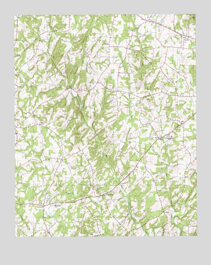
Frog Pond, NC USGS Topographic Map
Click on map above to begin viewing in our Map Viewer.

This topographic map contains these locations and features:
Feature Name Type Latitude Longitude GNIS ID View Map
Allison BranchStreamN35.2510°W80.3126°979983View Map
Bear Creek ChurchChurchN35.3374°W80.3195°980714View Map
BloomingtonPopulated PlaceN35.3326°W80.3053°1023840View Map
Canton ChurchChurchN35.3249°W80.2892°982611View Map
Efirds Mill (historical)LocaleN35.3235°W80.3290°1001946View Map
EndyPopulated PlaceN35.3049°W80.2756°1004033View Map
Endy SchoolSchoolN35.3054°W80.2767°1001948View Map
Endy Volunteer Fire DepartmentBuildingN35.3041°W80.2778°2638684View Map
Frog PondPopulated PlaceN35.2735°W80.3165°985467View Map
HillsPopulated PlaceN35.3132°W80.2609°986818View Map
LakesidePopulated PlaceN35.3613°W80.2578°1004030View Map
LambertPopulated PlaceN35.3135°W80.3595°988109View Map
Liberty Hill ChurchChurchN35.2726°W80.3273°988434View Map
Little Bear CreekStreamN35.2604°W80.2670°1024088View Map
Little Bear CreekStreamN35.3590°W80.3517°1024089View Map
Little CreekStreamN35.3354°W80.3367°1024095View Map
New Life ChurchChurchN35.3585°W80.3098°1004029View Map
Pleasant Grove ChurchChurchN35.2774°W80.3198°992470View Map
PlyerPopulated PlaceN35.3713°W80.2823°1024226View Map
Pole Bridge CreekStreamN35.3615°W80.3573°1024228View Map
Ramsey CreekStreamN35.2832°W80.3034°1024243View Map
Red CrossPopulated PlaceN35.2674°W80.3556°1024248View Map
Ridgecrest CemeteryCemeteryN35.3143°W80.3576°1004032View Map
Ridgecrest ChurchChurchN35.3188°W80.3623°1004031View Map
Ridgecrest SchoolSchoolN35.3199°W80.3648°993339View Map
Ridgecrest Volunteer Fire DepartmentBuildingN35.3194°W80.3626°2638883View Map
Running CreekStreamN35.3554°W80.3531°1024283View Map
Running Creek ChurchChurchN35.3129°W80.3745°993805View Map
Saint MartinPopulated PlaceN35.2638°W80.2728°1004035View Map
Saint Martins ChurchChurchN35.2635°W80.2734°994025View Map
Stanly CountyCivilN35.3120°W80.2510°1025844View Map
Stanly County Emergency Medical Services Base 3BuildingN35.2685°W80.3544°2720313View Map
Stony RunStreamN35.2518°W80.2848°1024326View Map
Town of Red CrossCivilN35.2660°W80.3622°2407184View Map
Township of AlmondCivilN35.3467°W80.3289°1027191View Map
Township of EndyCivilN35.2964°W80.2707°1027194View Map
Township SchoolSchoolN35.3054°W80.2781°996195View Map
West Stanly High SchoolSchoolN35.2679°W80.3470°1004034View Map
Whitley MillLocaleN35.3238°W80.3295°997269View Map

Note: Coordinates in the location and feature list above are referenced to NAD83 datum.


Copyright (C) 2008-2024 Ryan Niemi / Sunset Dynamics ... All Rights Reserved