TopoQuest Logo
Do you find TopoQuest useful?
Help keep TopoQuest running and adding new maps/features by donating!
Bitcoin:  19c7KJd3qBynnjoSw5npx9KScwjBe4ifkT
Litecoin:  LXs6TkuXGGXo1vDsWCkWVdjQX94eUKd6ui
Home View Maps Find Maps Find Places Resources & Links


Albemarle, North Carolina Topographic Map

USGS Map Title: Albemarle, NC
USGS Map MRC: 35080C2
DRG (GeoTIFF) Download: o35080c2.tif


Neighboring USGS Topographic Map Quads:


  Richfield, NC  
35080D3
 

  New London, NC  
35080D2
 

  Badin, NC  
35080D1
 

  Frog Pond, NC  
35080C3
 

  Albemarle, NC  
35080C2
 

  Morrow Mountain, NC  
35080C1
 

  Oakboro, NC  
35080B3
 

  Aquadale, NC  
35080B2
 

  Mount Gilead West, NC  
35080B1


Map MRC Location:

N36°
W81°
N36°
W80°
H8 H7 H6 H5 H4 H3 H2 H1
G8 G7 G6 G5 G4 G3 G2 G1
F8 F7 F6 F5 F4 F3 F2 F1
E8 E7 E6 E5 E4 E3 E2 E1
D8 D7 D6 D5 D4 D3 D2 D1
C8 C7 C6 C5 C4 C3 C2 C1
B8 B7 B6 B5 B4 B3 B2 B1
A8 A7 A6 A5 A4 A3 A2 A1
N35°
W81°
N35°
W80°

Albemarle, NC USGS 1:24K Topographic Map Preview:
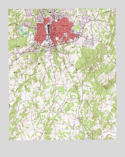
Albemarle, NC USGS Topographic Map
Click on map above to begin viewing in our Map Viewer.

This topographic map contains these locations and features:
Feature Name Type Latitude Longitude GNIS ID View Map
AlbemarlePopulated PlaceN35.3501°W80.2001°1023790View Map
Albemarle Airport (historical)AirportN35.3376°W80.1776°997912View Map
Albemarle City HallBuildingN35.3513°W80.1978°1004284View Map
Albemarle City Lake DamDamN35.3518°W80.2264°998861View Map
Albemarle Fire Department Station 1BuildingN35.3499°W80.1719°2638825View Map
Albemarle Fire Department Station 2BuildingN35.3549°W80.2163°2639467View Map
Albemarle High SchoolSchoolN35.3710°W80.1934°1001937View Map
Albemarle Junior High SchoolSchoolN35.3546°W80.1956°1004285View Map
Albemarle MallLocaleN35.3471°W80.1667°1001938View Map
Albemarle Police DepartmentBuildingN35.3525°W80.1983°2769804View Map
Albemarle Police East CommunityBuildingN35.3501°W80.1718°2770016View Map
Albemarle Post OfficePost OfficeN35.3475°W80.1991°1024969View Map
Albemarle West Police CommunityBuildingN35.3408°W80.2357°2770019View Map
American Spinning MillsBuildingN35.3524°W80.2028°1007791View Map
Anderson Grove ChurchChurchN35.3463°W80.1526°1023795View Map
Anderson HeightsPopulated PlaceN35.3426°W80.1523°1005994View Map
Badin Road Drive-InLocaleN35.3631°W80.1578°2558340View Map
Bethesda CemeteryCemeteryN35.3212°W80.1939°1023822View Map
Bethesda ChurchChurchN35.3276°W80.2009°1024716View Map
Calvary ChurchChurchN35.2549°W80.1573°1023872View Map
Calvary ChurchChurchN35.3585°W80.2084°1024698View Map
Cargill CorporationBuildingN35.3385°W80.1703°1007787View Map
Carolina Avenue ParkParkN35.3554°W80.2059°1001942View Map
Carolinas HealthCare System StanlyHospitalN35.3646°W80.1949°1024441View Map
Cedar VillagePopulated PlaceN35.3271°W80.2287°1005996View Map
Central Elementary SchoolSchoolN35.3532°W80.1956°1001943View Map
City of AlbemarleCivilN35.3600°W80.1921°2403073View Map
Coley BranchStreamN35.3607°W80.2048°1023916View Map
East Albemarle ChurchChurchN35.3651°W80.1626°1024717View Map
East Albermarle SchoolSchoolN35.3513°W80.1684°1023957View Map
East Side Volunteer Fire DepartmentBuildingN35.3635°W80.1539°2638485View Map
Eastgate Shopping CenterLocaleN35.3479°W80.1687°1001944View Map
Eastwood ParkPopulated PlaceN35.3643°W80.1664°1005999View Map
EndyLocaleN35.3313°W80.2267°1001947View Map
Fairview CemeteryCemeteryN35.3526°W80.1764°1023964View Map
Fairview Memorial Park CemeteryCemeteryN35.3527°W80.1754°1004282View Map
Friendship ChurchChurchN35.3454°W80.1867°1004281View Map
Full Gospel ChurchChurchN35.3393°W80.1609°1004278View Map
HeathwoodPopulated PlaceN35.3543°W80.1614°1006000View Map
Hillside ChurchChurchN35.3585°W80.2278°1004273View Map
Lakeview ChurchChurchN35.3701°W80.2253°1024077View Map
Little Long CreekStreamN35.3329°W80.2131°1024101View Map
Long LakeReservoirN35.3539°W80.2327°998862View Map
Melchor BranchStreamN35.3674°W80.1984°1017779View Map
Metal Forge CompanyBuildingN35.3413°W80.1712°1007788View Map
Mount Olive ChurchChurchN35.3632°W80.2114°1004272View Map
Mount Zion ChurchChurchN35.3479°W80.1859°1024715View Map
New Hope ChurchChurchN35.3326°W80.2001°1004270View Map
North Albemarle SchoolSchoolN35.3626°W80.2101°1001953View Map
North Carolina Department of Correction PrisonBuildingN35.3388°W80.2142°1001954View Map
North Carolina Department of TransportationBuildingN35.3554°W80.2173°1007794View Map
North SpringhavenPopulated PlaceN35.3715°W80.1659°1005997View Map
Old Freedom CemeteryCemeteryN35.3015°W80.2387°1004275View Map
Parkway ChurchChurchN35.3521°W80.1678°1004280View Map
Peggy Jo ParkParkN35.3699°W80.1926°1001957View Map
Pine Grove ChurchChurchN35.3199°W80.2487°1024217View Map
Poplin BranchStreamN35.3438°W80.1909°1004269View Map
Poplin CreekStreamN35.3418°W80.2084°1004268View Map
Poplin Grove CemeteryCemeteryN35.3396°W80.2201°1007789View Map
Poplins Grove ChurchChurchN35.3401°W80.2276°1024238View Map
PorterPopulated PlaceN35.2693°W80.1689°1024239View Map
Quenby MallLocaleN35.3657°W80.1934°1001958View Map
Rock CreekStreamN35.3401°W80.1973°1004267View Map
Rock Creek ParkParkN35.3349°W80.1970°1004279View Map
Royal ParkLocaleN35.3357°W80.2084°1001960View Map
Scaly Bark BranchStreamN35.3043°W80.2376°1027458View Map
Silver Spring ChurchChurchN35.2565°W80.2095°1024303View Map
South AlbemarleLocaleN35.3271°W80.2101°1001962View Map
South Albemarle ParkParkN35.3407°W80.1851°1001963View Map
Southside Volunteer Fire Department Station 1BuildingN35.3204°W80.1775°2639427View Map
Southside Volunteer Fire Department Station 2BuildingN35.3094°W80.2097°2639783View Map
Southwest Regional Education CenterBuildingN35.3407°W80.1851°1001964View Map
SpringhavenPopulated PlaceN35.3693°W80.1620°1005998View Map
Stanly County Court HouseBuildingN35.3496°W80.1978°1004283View Map
Stanly County FairgroundsLocaleN35.3543°W80.1709°1001966View Map
Stanly County Rescue SquadBuildingN35.3412°W80.2138°2720574View Map
Stanly County Sheriff's OfficeBuildingN35.3488°W80.1974°2769608View Map
Stanly Gardens CemeteryCemeteryN35.3479°W80.1587°1004277View Map
Stanly Technical InstituteSchoolN35.3396°W80.2364°1004274View Map
Sweet Home ChurchChurchN35.3465°W80.1448°1004276View Map
Town CreekStreamN35.3665°W80.1998°1024357View Map
Township of North AlbemarleCivilN35.3724°W80.1499°1027197View Map
Township of South AlbemarleCivilN35.3170°W80.1772°1027199View Map
Union ChapelChurchN35.3207°W80.1762°1024371View Map
Union Grove ChurchChurchN35.3007°W80.1951°1024372View Map
Vista ParkParkN35.3746°W80.2084°1001967View Map
W Albemarle SchoolSchoolN35.3626°W80.2095°1024382View Map
WABZBuildingN35.3518°W80.1995°1007793View Map
Wicasset ParkParkN35.3563°W80.1976°1001968View Map
Windsor HillsPopulated PlaceN35.3307°W80.2053°1005995View Map
Wiscasset Ball ParkParkN35.3688°W80.2081°1001969View Map
Wiscasset MillsBuildingN35.3576°W80.2039°1007790View Map
Wiscassett ParkParkN35.3568°W80.1984°1024410View Map
WZKY-AM (Albemarle)TowerN35.3607°W80.1773°1018436View Map
Youth Mens Christian AssociationBuildingN35.3571°W80.2003°1007792View Map

Note: Coordinates in the location and feature list above are referenced to NAD83 datum.


Copyright (C) 2008-2024 Ryan Niemi / Sunset Dynamics ... All Rights Reserved