TopoQuest Logo
Do you find TopoQuest useful?
Help keep TopoQuest running and adding new maps/features by donating!
Bitcoin:  19c7KJd3qBynnjoSw5npx9KScwjBe4ifkT
Litecoin:  LXs6TkuXGGXo1vDsWCkWVdjQX94eUKd6ui
Home View Maps Find Maps Find Places Resources & Links


Fruitland, New Mexico Topographic Map

USGS Map Title: Fruitland, NM
USGS Map MRC: 36108F4
DRG (GeoTIFF) Download: o36108f4.tif


Neighboring USGS Topographic Map Quads:


  Chimney Rock, NM  
36108G5
 

  Waterflow, NM  
36108G4
 

  Youngs Lake, NM  
36108G3
 

  The Hogback North, NM  
36108F5
 

  Fruitland, NM  
36108F4
 

  Kirtland, NM  
36108F3
 

  The Hogback South, NM  
36108E5
 

  Kirtland SW, NM  
36108E4
 

  Kirtland SE, NM  
36108E3


Map MRC Location:

N37°
W109°
N37°
W108°
H8 H7 H6 H5 H4 H3 H2 H1
G8 G7 G6 G5 G4 G3 G2 G1
F8 F7 F6 F5 F4 F3 F2 F1
E8 E7 E6 E5 E4 E3 E2 E1
D8 D7 D6 D5 D4 D3 D2 D1
C8 C7 C6 C5 C4 C3 C2 C1
B8 B7 B6 B5 B4 B3 B2 B1
A8 A7 A6 A5 A4 A3 A2 A1
N36°
W109°
N36°
W108°

Fruitland, NM USGS 1:24K Topographic Map Preview:
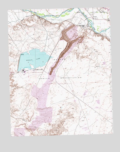
Fruitland, NM USGS Topographic Map
Click on map above to begin viewing in our Map Viewer.

This topographic map contains these locations and features:
Feature Name Type Latitude Longitude GNIS ID View Map
Brigham Young Junior House Historic SiteBuildingN36.7392°W108.3956°935204View Map
CGP-56 Historic SiteLocaleN36.7392°W108.3956°933580View Map
Farmers Mutual DitchCanalN36.7450°W108.3798°888977View Map
Four Corners PowerplantLocaleN36.6900°W108.4829°928941View Map
FruitlandPopulated PlaceN36.7392°W108.3956°902252View Map
Fruitland Irrigation CanalCanalN36.7381°W108.4920°927253View Map
Fruitland Post OfficePost OfficeN36.7392°W108.3956°937503View Map
Fruitland Trading CompanyBuildingN36.7392°W108.3956°935666View Map
Fruitland Weather StationLocaleN36.7392°W108.3956°932210View Map
Kirtland CemeteryCemeteryN36.7458°W108.3848°890724View Map
Lookout MineMineN36.7000°W108.4506°916324View Map
Morgan DamDamN36.6933°W108.4856°924030View Map
Morgan LakeReservoirN36.7004°W108.4705°892230View Map
Navajo MineMineN36.7089°W108.4295°892390View Map
Navajo StripMineN36.6806°W108.4784°916380View Map
NenahnezadPopulated PlaceN36.7361°W108.4181°1877178View Map
Nenahnezad Census Designated PlaceCensusN36.7354°W108.4253°2408912View Map
Nenahnezad Chapter HouseBuildingN36.7456°W108.4109°928996View Map
Nenahnezad Indian SchoolSchoolN36.7317°W108.4079°892424View Map
Nenahnezad SchoolSchoolN36.7392°W108.3956°901541View Map
Ojo Amarillo Elementary SchoolSchoolN36.7392°W108.3956°934136View Map
Richey PitMineN36.7286°W108.4062°916318View Map
San Juan PitMineN36.7250°W108.4048°916321View Map
Stevens ArroyoStreamN36.7417°W108.4042°897486View Map
Wilson SchoolSchoolN36.7367°W108.3765°896690View Map

Note: Coordinates in the location and feature list above are referenced to NAD83 datum.


Copyright (C) 2008-2025 Ryan Niemi / Sunset Dynamics ... All Rights Reserved