TopoQuest Logo
Do you find TopoQuest useful?
Help keep TopoQuest running and adding new maps/features by donating!
Bitcoin:  19c7KJd3qBynnjoSw5npx9KScwjBe4ifkT
Litecoin:  LXs6TkuXGGXo1vDsWCkWVdjQX94eUKd6ui
Home View Maps Find Maps Find Places Resources & Links


Kirtland, New Mexico Topographic Map

USGS Map Title: Kirtland, NM
USGS Map MRC: 36108F3
DRG (GeoTIFF) Download: o36108f3.tif


Neighboring USGS Topographic Map Quads:


  Waterflow, NM  
36108G4
 

  Youngs Lake, NM  
36108G3
 

  Farmington North, NM  
36108G2
 

  Fruitland, NM  
36108F4
 

  Kirtland, NM  
36108F3
 

  Farmington South, NM  
36108F2
 

  Kirtland SW, NM  
36108E4
 

  Kirtland SE, NM  
36108E3
 

  Hugh Lake, NM  
36108E2


Map MRC Location:

N37°
W109°
N37°
W108°
H8 H7 H6 H5 H4 H3 H2 H1
G8 G7 G6 G5 G4 G3 G2 G1
F8 F7 F6 F5 F4 F3 F2 F1
E8 E7 E6 E5 E4 E3 E2 E1
D8 D7 D6 D5 D4 D3 D2 D1
C8 C7 C6 C5 C4 C3 C2 C1
B8 B7 B6 B5 B4 B3 B2 B1
A8 A7 A6 A5 A4 A3 A2 A1
N36°
W109°
N36°
W108°

Kirtland, NM USGS 1:24K Topographic Map Preview:
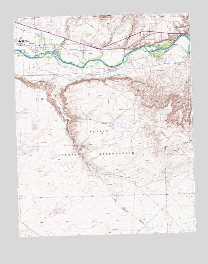
Kirtland, NM USGS Topographic Map
Click on map above to begin viewing in our Map Viewer.

This topographic map contains these locations and features:
Feature Name Type Latitude Longitude GNIS ID View Map
Central High SchoolSchoolN36.7372°W108.3715°887383View Map
Central Junior High SchoolSchoolN36.7369°W108.3687°887385View Map
Coolidge ArroyoStreamN36.7286°W108.3429°887804View Map
Dain ArroyoStreamN36.7247°W108.3134°888178View Map
Davenport Airport (historical)AirportN36.6328°W108.3115°936952View Map
Deeper Faith Ministries ChurchChurchN36.7342°W108.3598°919926View Map
First Baptist ChurchChurchN36.7342°W108.3598°920485View Map
Grace B Wilson SchoolSchoolN36.7342°W108.3598°934130View Map
Harper Hill PitMineN36.7414°W108.3687°916327View Map
KirtlandPopulated PlaceN36.7342°W108.3598°902282View Map
Kirtland Census Designated Place (historical)CensusN36.7438°W108.3513°2408490View Map
Kirtland Elementary SchoolSchoolN36.7342°W108.3598°934128View Map
Kirtland Middle SchoolSchoolN36.7342°W108.3598°934131View Map
Kirtland Post OfficePost OfficeN36.7417°W108.3574°938294View Map
La Plata RiverStreamN36.7361°W108.2517°897392View Map
Locke ArroyoStreamN36.7264°W108.2965°891242View Map
Ojo AmarilloPopulated PlaceN36.6933°W108.3692°1867387View Map
Ojo Amarillo CanyonValleyN36.7133°W108.3451°892830View Map
Ojo Amarillo Census Designated PlaceCensusN36.6941°W108.3704°2408981View Map
Ruth N Bond Elementary SchoolSchoolN36.7342°W108.3598°934129View Map
Saint Michael ChurchChurchN36.7156°W108.3442°894286View Map
San Juan County Fire District 1 Valley Station 1BuildingN36.7469°W108.3750°2657799View Map
San Juan County Fire District 1 Valley Station 2BuildingN36.7338°W108.3661°2658206View Map
San Juan County Fire District 1 Valley Station 4BuildingN36.7350°W108.3271°2658205View Map
San Juan County Sheriff's Office KirtlandBuildingN36.7415°W108.3588°2722611View Map
The Church of Jesus Christ of Latter Day SaintsChurchN36.7342°W108.3598°920440View Map
Town of KirtlandCivilN36.7397°W108.3451°2783911View Map
Twin MoundsSummitN36.7494°W108.3106°895950View Map
Twin MountainSummitN36.7417°W108.3090°914319View Map
University of New Mexico Experimental FarmSchoolN36.6883°W108.3079°896004View Map
Upper FruitlandPopulated PlaceN36.7158°W108.3142°1852638View Map
Upper Fruitland Census Designated PlaceCensusN36.7205°W108.3231°2409381View Map

Note: Coordinates in the location and feature list above are referenced to NAD83 datum.


Copyright (C) 2008-2024 Ryan Niemi / Sunset Dynamics ... All Rights Reserved