TopoQuest Logo
Do you find TopoQuest useful?
Help keep TopoQuest running and adding new maps/features by donating!
Bitcoin:  19c7KJd3qBynnjoSw5npx9KScwjBe4ifkT
Litecoin:  LXs6TkuXGGXo1vDsWCkWVdjQX94eUKd6ui
Home View Maps Find Maps Find Places Resources & Links


Fryeburg, Maine Topographic Map

USGS Map Title: Fryeburg, ME
USGS Map MRC: 44070A8
DRG (GeoTIFF) Download: o44070a8.tif


Neighboring USGS Topographic Map Quads:


  Chatham, NH  
44071B1
 

  Center Lovell, ME  
44070B8
 

  North Waterford, ME  
44070B7
 

  North Conway East, NH  
44071A1
 

  Fryeburg, ME  
44070A8
 

  Pleasant Mountain, ME  
44070A7
 

  Conway, NH  
43071H1
 

  Brownfield, ME  
43070H8
 

  Hiram, ME  
43070H7


Map MRC Location:

N45°
W71°
N45°
W70°
H8 H7 H6 H5 H4 H3 H2 H1
G8 G7 G6 G5 G4 G3 G2 G1
F8 F7 F6 F5 F4 F3 F2 F1
E8 E7 E6 E5 E4 E3 E2 E1
D8 D7 D6 D5 D4 D3 D2 D1
C8 C7 C6 C5 C4 C3 C2 C1
B8 B7 B6 B5 B4 B3 B2 B1
A8 A7 A6 A5 A4 A3 A2 A1
N44°
W71°
N44°
W70°

Fryeburg, ME USGS 1:24K Topographic Map Preview:
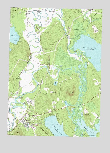
Fryeburg, ME USGS Topographic Map
Click on map above to begin viewing in our Map Viewer.

This topographic map contains these locations and features:
Feature Name Type Latitude Longitude GNIS ID View Map
Abbott Cemetery 1CemeteryN44.0898°W70.9402°561043View Map
Abbott Cemetery 2CemeteryN44.0900°W70.9410°2724604View Map
Adams SchoolSchoolN44.1148°W70.9753°561091View Map
Birch HillSummitN44.0770°W70.9915°562290View Map
Black BrookStreamN44.0165°W70.8762°562387View Map
Bog PondLakeN44.0518°W70.9362°562686View Map
Bradley CemeteryCemeteryN44.0845°W70.9512°562864View Map
Bradley Memorial ParkParkN44.0195°W70.9740°1907935View Map
Cat PondLakeN44.0329°W70.9215°563686View Map
Chandler CemeteryCemeteryN44.0712°W70.9445°563819View Map
Charles CemeteryCemeteryN44.0980°W70.9760°563855View Map
Charles Snow SchoolSchoolN44.0148°W70.9746°1907964View Map
Church of the New JerusalemChurchN44.0157°W70.9804°1907968View Map
Dead LakeLakeN44.0628°W70.8968°564872View Map
District Number One SchoolhouseSchoolN44.0162°W70.9828°1907984View Map
Fight BrookStreamN44.0203°W70.9351°566147View Map
First Assembly of God ChurchChurchN44.0167°W70.9873°1908007View Map
First Church of Christ ScientistChurchN44.0212°W70.9792°1908011View Map
First Congregational ChurchChurchN44.0175°W70.9793°1908016View Map
Fish StreetPopulated PlaceN44.1012°W70.9592°566226View Map
Fish Street CemeteryCemeteryN44.1006°W70.9602°2736860View Map
FryeburgPopulated PlaceN44.0165°W70.9806°566636View Map
Fryeburg AcademySchoolN44.0201°W70.9753°566637View Map
Fryeburg Census Designated PlaceCensusN44.0201°W70.9733°2377913View Map
Fryeburg CenterPopulated PlaceN44.0695°W70.9448°566638View Map
Fryeburg DamDamN44.0125°W70.9709°1774286View Map
Fryeburg Fair Farm MuseumBuildingN44.0337°W70.9690°1908020View Map
Fryeburg FairgroundsLocaleN44.0348°W70.9695°1908021View Map
Fryeburg Fire DepartmentBuildingN44.0160°W70.9828°2553174View Map
Fryeburg Police DepartmentBuildingN44.0194°W70.9689°2735939View Map
Fryeburg Post OfficePost OfficeN44.0150°W70.9836°1908022View Map
Fryeburg Public LibraryBuildingN44.0152°W70.9822°1908023View Map
Fryeburg Rescue Station Ambulance ServiceBuildingN44.0195°W70.9667°2666756View Map
Fryeburg SchoolSchoolN44.0199°W70.9753°2738201View Map
Hemlock BridgeBridgeN44.0795°W70.9031°1908046View Map
Highland ParkPopulated PlaceN44.0431°W70.9415°579408View Map
Horseshoe PondLakeN44.0826°W70.9070°568312View Map
Horseshoe PondLakeN44.1161°W70.9637°568313View Map
Hunt PondLakeN44.0839°W70.9988°581064View Map
Jockey CapSummitN44.0222°W70.9624°568863View Map
Kezar PondLakeN44.0848°W70.8870°569146View Map
Kezar RiverStreamN44.0948°W70.9176°581083View Map
Kezar River Mill DamDamN44.1245°W70.8912°1774531View Map
Kimball BrookStreamN44.1062°W70.9951°581084View Map
Loon IslandIslandN44.0123°W70.9337°570360View Map
Loon IslandIslandN44.0928°W70.9901°570361View Map
Lovell Volunteer Fire Department Village StationBuildingN44.1242°W70.8895°2553066View Map
Lovewell PondLakeN44.0057°W70.9319°581451View Map
Lower Kimball PondLakeN44.0976°W70.9957°570512View Map
Main Street Historic DistrictParkN44.0148°W70.9798°1908076View Map
Menotomy Yard Number 1CemeteryN44.0534°W70.9246°2724717View Map
Menotomy Yard Number 2CemeteryN44.0535°W70.9242°2724718View Map
Mill PondReservoirN44.0067°W70.8912°1774532View Map
Molly Ockett Middle SchoolSchoolN44.0219°W70.9661°1908090View Map
Mount TomSummitN44.0421°W70.9145°577174View Map
New Life Christian AcademySchoolN44.0153°W70.9834°2738197View Map
New Suncook Elementary SchoolSchoolN44.1221°W70.9024°1908097View Map
North FryeburgPopulated PlaceN44.1209°W70.9773°572339View Map
North Fryeburg CemeteryCemeteryN44.1138°W70.9763°2736378View Map
Oak HillSummitN44.0005°W70.9566°572576View Map
Pine Grove CemeteryCemeteryN44.0203°W70.9723°573355View Map
Pleasant PondLakeN44.0080°W70.8884°573508View Map
Popple Hill BrookStreamN44.1115°W70.8920°581180View Map
Prays BrookStreamN44.1028°W70.9020°581182View Map
Riverside CemeteryCemeteryN44.1074°W70.9656°574252View Map
Saco River ReservoirReservoirN44.0382°W70.9838°1773584View Map
Saco Valley Fire Department Station 1BuildingN44.1214°W70.9786°2552805View Map
Sadie F Adams SchoolSchoolN44.0178°W70.9742°1908171View Map
Saint Elizabeth Ann Seton ChurchChurchN44.0170°W70.9787°1908175View Map
Schoolhouse Yard CemeteryCemeteryN44.0479°W70.8758°2724786View Map
Smart CemeteryCemeteryN44.1044°W70.8845°575576View Map
Smarts HillSummitN44.1026°W70.8820°575580View Map
Stanley HillSummitN44.0213°W70.8933°576242View Map
Starks MountainSummitN44.0017°W70.9855°576273View Map
Swans FallsFallsN44.0381°W70.9826°576586View Map
Swans Falls DamDamN44.0382°W70.9838°1773583View Map
Swimming BogSwampN44.1031°W70.9067°576621View Map
Tib FieldAirportN44.1097°W70.9563°2443594View Map
Toll Bridge CemeteryCemeteryN44.0971°W70.9213°2736401View Map
Town of FryeburgCivilN44.0548°W70.9383°582485View Map
Walker IslandIslandN44.0051°W70.9009°577795View Map
Wards PondReservoirN44.0125°W70.9707°577833View Map
Weeks BrookStreamN44.0351°W70.9906°577969View Map
West FryeburgPopulated PlaceN44.0640°W70.9801°578141View Map
West Fryeburg CemeteryCemeteryN44.0556°W70.9842°578142View Map
White Lot BrookStreamN44.0367°W70.9942°872912View Map
Wiley CemeteryCemeteryN44.1046°W70.8848°578487View Map

Note: Coordinates in the location and feature list above are referenced to NAD83 datum.


Copyright (C) 2008-2024 Ryan Niemi / Sunset Dynamics ... All Rights Reserved