TopoQuest Logo
Do you find TopoQuest useful?
Help keep TopoQuest running and adding new maps/features by donating!
Bitcoin:  19c7KJd3qBynnjoSw5npx9KScwjBe4ifkT
Litecoin:  LXs6TkuXGGXo1vDsWCkWVdjQX94eUKd6ui
Home View Maps Find Maps Find Places Resources & Links


Gallinas Peak, New Mexico Topographic Map

USGS Map Title: Gallinas Peak, NM
USGS Map MRC: 34107B4
DRG (GeoTIFF) Download: o34107b4.tif


Neighboring USGS Topographic Map Quads:


  Indian Mesa, NM  
34107C5
 

  Indian Spring Canyon, NM  
34107C4
 

  Mesa Cencerro, NM  
34107C3
 

  Lion Mountain, NM  
34107B5
 

  Gallinas Peak, NM  
34107B4
 

  Silver Hill, NM  
34107B3
 

  Arrowhead Well, NM  
34107A5
 

  Tres Montosas, NM  
34107A4
 

  Arroyo Landavaso, NM  
34107A3


Map MRC Location:

N35°
W108°
N35°
W107°
H8 H7 H6 H5 H4 H3 H2 H1
G8 G7 G6 G5 G4 G3 G2 G1
F8 F7 F6 F5 F4 F3 F2 F1
E8 E7 E6 E5 E4 E3 E2 E1
D8 D7 D6 D5 D4 D3 D2 D1
C8 C7 C6 C5 C4 C3 C2 C1
B8 B7 B6 B5 B4 B3 B2 B1
A8 A7 A6 A5 A4 A3 A2 A1
N34°
W108°
N34°
W107°

Gallinas Peak, NM USGS 1:24K Topographic Map Preview:
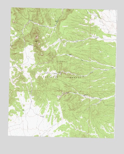
Gallinas Peak, NM USGS Topographic Map
Click on map above to begin viewing in our Map Viewer.

This topographic map contains these locations and features:
Feature Name Type Latitude Longitude GNIS ID View Map
Ake WellWellN34.1937°W107.3778°903029View Map
AnabelMineN34.1376°W107.3936°917908View Map
Bojo MontosoMineN34.1431°W107.4284°917991View Map
Bojo Placer Number OneMineN34.1376°W107.3839°917477View Map
Council RockAreaN34.1673°W107.4095°905437View Map
Council Rock Post Office (historical)Post OfficeN34.1673°W107.4070°937641View Map
Council Rock RanchLocaleN34.1662°W107.4128°905439View Map
Deep WellWellN34.2237°W107.4023°905676View Map
East WellWellN34.1578°W107.3973°905997View Map
Gallinas MountainsRangeN34.2145°W107.4903°906456View Map
Gallinas PeakSummitN34.2176°W107.4709°906457View Map
Gallinas SpringSpringN34.1881°W107.4398°906460View Map
Gallinas Spring Dug WellWellN34.1848°W107.4120°906461View Map
Gallinas Trick TankReservoirN34.2119°W107.4814°914098View Map
Gibson WellWellN34.1445°W107.4592°906535View Map
Heifer WellReservoirN34.1581°W107.3984°1989150View Map
Jones TanksReservoirN34.2376°W107.4456°907434View Map
Jones WellWellN34.2334°W107.4467°907435View Map
McGee CanyonValleyN34.1934°W107.3761°908521View Map
McGee SpringSpringN34.2051°W107.4303°908523View Map
Medley CemeteryCemeteryN34.1636°W107.3915°908560View Map
Piņon WellWellN34.1501°W107.4817°909724View Map
Rock Header TankReservoirN34.1647°W107.4410°914099View Map
Sawmill WellWellN34.2376°W107.4775°910855View Map
South WellWellN34.1681°W107.4737°911283View Map
Whiskey WellWellN34.2126°W107.4992°912289View Map

Note: Coordinates in the location and feature list above are referenced to NAD83 datum.


Copyright (C) 2008-2025 Ryan Niemi / Sunset Dynamics ... All Rights Reserved