TopoQuest Logo
Do you find TopoQuest useful?
Help keep TopoQuest running and adding new maps/features by donating!
Bitcoin:  19c7KJd3qBynnjoSw5npx9KScwjBe4ifkT
Litecoin:  LXs6TkuXGGXo1vDsWCkWVdjQX94eUKd6ui
Home View Maps Find Maps Find Places Resources & Links


Indian Spring Canyon, New Mexico Topographic Map

USGS Map Title: Indian Spring Canyon, NM
USGS Map MRC: 34107C4
DRG (GeoTIFF) Download: o34107c4.tif


Neighboring USGS Topographic Map Quads:


  Table Mountain, NM  
34107D5
 

  Puertecito, NM  
34107D4
 

  La Jara Peak, NM  
34107D3
 

  Indian Mesa, NM  
34107C5
 

  Indian Spring Canyon, NM  
34107C4
 

  Mesa Cencerro, NM  
34107C3
 

  Lion Mountain, NM  
34107B5
 

  Gallinas Peak, NM  
34107B4
 

  Silver Hill, NM  
34107B3


Map MRC Location:

N35°
W108°
N35°
W107°
H8 H7 H6 H5 H4 H3 H2 H1
G8 G7 G6 G5 G4 G3 G2 G1
F8 F7 F6 F5 F4 F3 F2 F1
E8 E7 E6 E5 E4 E3 E2 E1
D8 D7 D6 D5 D4 D3 D2 D1
C8 C7 C6 C5 C4 C3 C2 C1
B8 B7 B6 B5 B4 B3 B2 B1
A8 A7 A6 A5 A4 A3 A2 A1
N34°
W108°
N34°
W107°

Indian Spring Canyon, NM USGS 1:24K Topographic Map Preview:
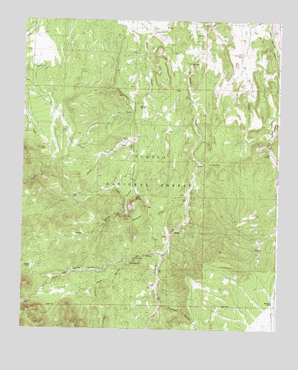
Indian Spring Canyon, NM USGS Topographic Map
Click on map above to begin viewing in our Map Viewer.

This topographic map contains these locations and features:
Feature Name Type Latitude Longitude GNIS ID View Map
26-25-1 Water WellWellN34.3626°W107.4212°925849View Map
26-25-2 Water WellWellN34.3637°W107.4131°925850View Map
26-26-1 Water WellWellN34.3681°W107.4323°925665View Map
A-4 Water WellWellN34.3301°W107.4978°925856View Map
Abbe SpringSpringN34.3209°W107.3795°902930View Map
Alamo Navajo Airport (historical)AirportN34.3592°W107.4953°936886View Map
Burro SpringSpringN34.2960°W107.4500°904244View Map
Caņon CencerroArroyoN34.2967°W107.3750°904635View Map
Chavez Ranch (historical)LocaleN34.3265°W107.4487°905056View Map
Cibola National ForestForestN34.2516°W107.4274°1851853View Map
Coal SpringSpringN34.3163°W107.4092°937085View Map
Corkscrew CanyonValleyN34.2595°W107.4314°905344View Map
Diego Monte Water WellWellN34.3651°W107.4112°925851View Map
Dove SpringSpringN34.2768°W107.4469°905844View Map
Dove Spring CanyonValleyN34.2806°W107.4320°905845View Map
Earth TankReservoirN34.3351°W107.3892°914080View Map
Fretoso RanchLocaleN34.3701°W107.4348°906402View Map
Heifer TankReservoirN34.2519°W107.3876°914111View Map
Hook RanchMineN34.3048°W107.4212°917420View Map
Hook RanchLocaleN34.2881°W107.4289°907069View Map
Hot Spot MinesMineN34.3167°W107.4084°907121View Map
Indian Spring CanyonValleyN34.3356°W107.4348°907230View Map
Indian TankReservoirN34.2751°W107.4956°907237View Map
Little WellWellN34.3023°W107.4200°908067View Map
Mag 1MineN34.3103°W107.4175°917424View Map
Maverick DrawValleyN34.3009°W107.4192°908470View Map
Mexican TankReservoirN34.2614°W107.3768°908669View Map
Middle WellWellN34.2676°W107.4345°908721View Map
Montoya SpringSpringN34.3392°W107.4423°908865View Map
Murdo SpringSpringN34.3639°W107.3803°937086View Map
New WellWellN34.3034°W107.4734°925658View Map
North WellWellN34.2828°W107.3837°909205View Map
Reid SpringSpringN34.3037°W107.4431°910115View Map
Secatero Water WellWellN34.3512°W107.4395°925661View Map
Section 31 Water WellWellN34.3612°W107.3942°925847View Map
Section Thirty TankWellN34.3612°W107.3937°910913View Map
Thomas Canoda RanchLocaleN34.3567°W107.4920°914081View Map
Three Log Spring CanyonValleyN34.2770°W107.4462°911680View Map
Three Log WellWellN34.2609°W107.4978°911681View Map
Windmill Number 1LocaleN34.3301°W107.4975°912457View Map
Windmill Number 2LocaleN34.3556°W107.4945°912459View Map

Note: Coordinates in the location and feature list above are referenced to NAD83 datum.


Copyright (C) 2008-2025 Ryan Niemi / Sunset Dynamics ... All Rights Reserved