TopoQuest Logo
Do you find TopoQuest useful?
Help keep TopoQuest running and adding new maps/features by donating!
Bitcoin:  19c7KJd3qBynnjoSw5npx9KScwjBe4ifkT
Litecoin:  LXs6TkuXGGXo1vDsWCkWVdjQX94eUKd6ui
Home View Maps Find Maps Find Places Resources & Links


Garland, North Carolina Topographic Map

USGS Map Title: Garland, NC
USGS Map MRC: 34078G4
DRG (GeoTIFF) Download: o34078g4.tif


Neighboring USGS Topographic Map Quads:


  Roseboro, NC  
34078H5
 

  Bonnetsville, NC  
34078H4
 

  Clinton South, NC  
34078H3
 

  Ammon, NC  
34078G5
 

  Garland, NC  
34078G4
 

  Ingold, NC  
34078G3
 

  Elizabethtown North, NC  
34078F5
 

  White Lake, NC  
34078F4
 

  Tomahawk, NC  
34078F3


Map MRC Location:

N35°
W79°
N35°
W78°
H8 H7 H6 H5 H4 H3 H2 H1
G8 G7 G6 G5 G4 G3 G2 G1
F8 F7 F6 F5 F4 F3 F2 F1
E8 E7 E6 E5 E4 E3 E2 E1
D8 D7 D6 D5 D4 D3 D2 D1
C8 C7 C6 C5 C4 C3 C2 C1
B8 B7 B6 B5 B4 B3 B2 B1
A8 A7 A6 A5 A4 A3 A2 A1
N34°
W79°
N34°
W78°

Garland, NC USGS 1:24K Topographic Map Preview:
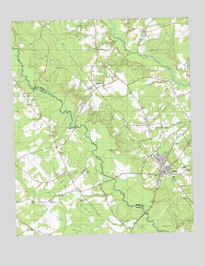
Garland, NC USGS Topographic Map
Click on map above to begin viewing in our Map Viewer.

This topographic map contains these locations and features:
Feature Name Type Latitude Longitude GNIS ID View Map
Antioch ChurchChurchN34.7974°W78.4681°980214View Map
Cypress CreekStreamN34.7985°W78.4456°983889View Map
Cypress Creek ChurchChurchN34.7693°W78.4753°983897View Map
Derose PondReservoirN34.8647°W78.4072°998171View Map
Derose Pond DamDamN34.8635°W78.4081°998170View Map
Dismal BaySwampN34.8585°W78.4633°984203View Map
Ebenezer ChurchChurchN34.8613°W78.3858°984583View Map
Evening Light ChurchChurchN34.7766°W78.3833°1026209View Map
Galilee ChurchChurchN34.7813°W78.3883°1026207View Map
GarlandPopulated PlaceN34.7863°W78.3942°985570View Map
Garland ChurchChurchN34.7693°W78.4519°1026210View Map
Garland Elementary SchoolSchoolN34.7885°W78.3928°1006934View Map
Garland Fire DepartmentBuildingN34.7851°W78.3977°2638855View Map
Garland Police DepartmentBuildingN34.7850°W78.3973°2130861View Map
Garland Post OfficePost OfficeN34.7837°W78.3945°2773915View Map
Garland Rescue and Emergency Medical ServicesBuildingN34.7841°W78.3979°2720640View Map
Grace ChurchChurchN34.7832°W78.3994°1026212View Map
Green BridgeBridgeN34.8121°W78.4581°986044View Map
Horsepen BranchStreamN34.8627°W78.4286°987126View Map
Indian Camp BaySwampN34.7577°W78.4720°987336View Map
Johnson Mill RaceStreamN34.8552°W78.4164°1025432View Map
Long BranchStreamN34.7585°W78.4075°1025494View Map
Marry Branch BaySwampN34.7668°W78.4503°989358View Map
Melvin BridgeBridgeN34.8363°W78.4847°989717View Map
Miller ChapelChurchN34.7729°W78.4706°989998View Map
Mount Elam ChurchChurchN34.8277°W78.4897°1000888View Map
ParkersburgPopulated PlaceN34.8371°W78.4433°991873View Map
Peters CreekStreamN34.8549°W78.4964°992086View Map
Rattlesnake BranchStreamN34.8388°W78.3894°993047View Map
Sinai ChurchChurchN34.7704°W78.4892°994858View Map
Smith ChapelChurchN34.8582°W78.4386°994954View Map
Town of GarlandCivilN34.7858°W78.3947°2406545View Map
Township of Cypress CreekCivilN34.7673°W78.4666°1026428View Map
Twin Oak AirportAirportN34.8702°W78.4730°2679143View Map
Twin Oak AirportBuildingN34.8695°W78.4728°2506029View Map

Note: Coordinates in the location and feature list above are referenced to NAD83 datum.


Copyright (C) 2008-2024 Ryan Niemi / Sunset Dynamics ... All Rights Reserved