TopoQuest Logo
Do you find TopoQuest useful?
Help keep TopoQuest running and adding new maps/features by donating!
Bitcoin:  19c7KJd3qBynnjoSw5npx9KScwjBe4ifkT
Litecoin:  LXs6TkuXGGXo1vDsWCkWVdjQX94eUKd6ui
Home View Maps Find Maps Find Places Resources & Links


Bonnetsville, North Carolina Topographic Map

USGS Map Title: Bonnetsville, NC
USGS Map MRC: 34078H4
DRG (GeoTIFF) Download: o34078h4.tif


Neighboring USGS Topographic Map Quads:


  Salemburg, NC  
35078A5
 

  Bearskin, NC  
35078A4
 

  Clinton North, NC  
35078A3
 

  Roseboro, NC  
34078H5
 

  Bonnetsville, NC  
34078H4
 

  Clinton South, NC  
34078H3
 

  Ammon, NC  
34078G5
 

  Garland, NC  
34078G4
 

  Ingold, NC  
34078G3


Map MRC Location:

N35°
W79°
N35°
W78°
H8 H7 H6 H5 H4 H3 H2 H1
G8 G7 G6 G5 G4 G3 G2 G1
F8 F7 F6 F5 F4 F3 F2 F1
E8 E7 E6 E5 E4 E3 E2 E1
D8 D7 D6 D5 D4 D3 D2 D1
C8 C7 C6 C5 C4 C3 C2 C1
B8 B7 B6 B5 B4 B3 B2 B1
A8 A7 A6 A5 A4 A3 A2 A1
N34°
W79°
N34°
W78°

Bonnetsville, NC USGS 1:24K Topographic Map Preview:
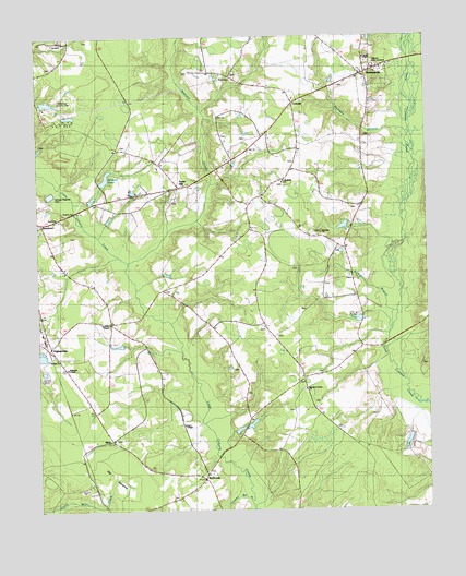
Bonnetsville, NC USGS Topographic Map
Click on map above to begin viewing in our Map Viewer.

This topographic map contains these locations and features:
Feature Name Type Latitude Longitude GNIS ID View Map
Andrews ChapelChurchN34.9246°W78.4770°980187View Map
Bearskin SwampStreamN34.9399°W78.4708°1025121View Map
Big Piney Grove ChurchChurchN34.9068°W78.4142°1004317View Map
BonnetsvillePopulated PlaceN34.9904°W78.3947°1019250View Map
Bonnetsville Census Designated PlaceCensusN34.9993°W78.3961°2402703View Map
Carrs ChapelChurchN34.8977°W78.4533°1004486View Map
ConcordPopulated PlaceN34.9829°W78.4167°983423View Map
Cooper ChapelChurchN34.9946°W78.3942°1004482View Map
Elizabeth ChurchChurchN34.9618°W78.4206°984685View Map
Fox LakeReservoirN34.9885°W78.3781°998269View Map
Fox Lake DamDamN34.9885°W78.3781°998268View Map
Halls PondReservoirN34.9665°W78.4364°998245View Map
Halls Pond DamDamN34.9668°W78.4364°998244View Map
Harmony ChurchChurchN34.9479°W78.4081°986419View Map
HighsmithsPopulated PlaceN34.9185°W78.4967°986784View Map
Hillcrest Memorial GardensCemeteryN34.9921°W78.3914°1004483View Map
Hobbs PondReservoirN34.9252°W78.3968°986860View Map
Lakewood Country ClubLocaleN34.9835°W78.4928°1004481View Map
Lockamy Mill BranchStreamN34.8779°W78.4328°1025490View Map
McDanielsPopulated PlaceN34.8835°W78.4469°989556View Map
MintzPopulated PlaceN34.8941°W78.4772°1021495View Map
Moccasin BranchStreamN34.9738°W78.3803°1025552View Map
Old SavannaFlatN34.8854°W78.4756°1025594View Map
Robinson ChapelChurchN34.9129°W78.4906°1004485View Map
Roseboro Industrial ParkLocaleN34.9498°W78.4943°2505183View Map
Snow HillPopulated PlaceN34.9607°W78.4547°1022687View Map
Springs ChurchChurchN34.9154°W78.4939°1004484View Map
Township of McDanielsCivilN34.8875°W78.4391°1027176View Map
Turkey BranchStreamN34.9271°W78.3847°1025760View Map
Upper Jb Williams Pond DamDamN34.9618°W78.4797°998234View Map
Williams PondReservoirN34.9630°W78.4777°1025803View Map

Note: Coordinates in the location and feature list above are referenced to NAD83 datum.


Copyright (C) 2008-2024 Ryan Niemi / Sunset Dynamics ... All Rights Reserved