TopoQuest Logo
Do you find TopoQuest useful?
Help keep TopoQuest running and adding new maps/features by donating!
Bitcoin:  19c7KJd3qBynnjoSw5npx9KScwjBe4ifkT
Litecoin:  LXs6TkuXGGXo1vDsWCkWVdjQX94eUKd6ui
Home View Maps Find Maps Find Places Resources & Links


Ashwood, Oregon Topographic Map

USGS Map Title: Ashwood, OR
USGS Map MRC: 44120F7
DRG (GeoTIFF) Download: o44120f7.tif


Neighboring USGS Topographic Map Quads:


  Willowdale, OR  
44120G8
 

  Degner Canyon, OR  
44120G7
 

  Donnybrook, OR  
44120G6
 

  Teller Butte, OR  
44120F8
 

  Ashwood, OR  
44120F7
 

  Axehandle Butte, OR  
44120F6
 

  Brewer Reservoir, OR  
44120E8
 

  Foley Butte, OR  
44120E7
 

  Dutchman Creek, OR  
44120E6


Map MRC Location:

N45°
W121°
N45°
W120°
H8 H7 H6 H5 H4 H3 H2 H1
G8 G7 G6 G5 G4 G3 G2 G1
F8 F7 F6 F5 F4 F3 F2 F1
E8 E7 E6 E5 E4 E3 E2 E1
D8 D7 D6 D5 D4 D3 D2 D1
C8 C7 C6 C5 C4 C3 C2 C1
B8 B7 B6 B5 B4 B3 B2 B1
A8 A7 A6 A5 A4 A3 A2 A1
N44°
W121°
N44°
W120°

Ashwood, OR USGS 1:24K Topographic Map Preview:
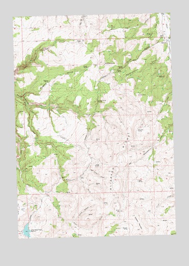
Ashwood, OR USGS Topographic Map
Click on map above to begin viewing in our Map Viewer.

This topographic map contains these locations and features:
Feature Name Type Latitude Longitude GNIS ID View Map
Anderson SpringSpringN44.7194°W120.7899°1116940View Map
AshwoodPopulated PlaceN44.7337°W120.7545°1117066View Map
Ashwood DivisionCivilN44.6490°W120.7911°1937956View Map
Ashwood Elementary SchoolSchoolN44.7353°W120.7560°2559813View Map
Ashwood Post OfficePost OfficeN44.7337°W120.7545°1164863View Map
Black PlaceLocaleN44.6382°W120.7728°1136077View Map
Blizzard RidgeRidgeN44.6698°W120.8025°1117820View Map
Clarke OrchardBasinN44.6832°W120.8178°1638701View Map
Clarke SpringsSpringN44.6647°W120.8090°1118973View Map
County Trough SpringSpringN44.7011°W120.8102°1119395View Map
Hat RockPillarN44.7040°W120.7767°1121653View Map
Indian ArrowsBasinN44.6585°W120.8264°1122196View Map
Jory BasinBasinN44.7418°W120.7936°1122536View Map
Jumpoff JoeLocaleN44.6585°W120.8411°1122556View Map
Lee Woods SpringSpringN44.7217°W120.8041°1158320View Map
Little Willow Creek DamDamN44.6283°W120.8720°1133590View Map
Little Willow Creek ReservoirReservoirN44.6291°W120.8691°1123317View Map
Maud Post Office (historical)Post OfficeN44.7429°W120.7789°1164500View Map
McCorkle SpringSpringN44.6848°W120.7793°1123920View Map
Offatt SpringSpringN44.6556°W120.7801°1124939View Map
Pine CreekStreamN44.6998°W120.8648°1125389View Map
Prineville GulchValleyN44.7473°W120.7581°1125671View Map
Pump SpringSpringN44.7178°W120.7945°1125702View Map
Rock Crusher CanyonValleyN44.6626°W120.8195°1126186View Map
Rutter CanyonValleyN44.6340°W120.8325°1126382View Map
Ryegrass HollowValleyN44.7048°W120.8695°1126391View Map
Ryegrass SpringSpringN44.7125°W120.8488°1126393View Map
Sampson MountainRidgeN44.6318°W120.7809°1126541View Map
Sampson SpringSpringN44.6292°W120.7887°1126542View Map
Sand MountainSummitN44.7143°W120.7614°1126576View Map
Slaughterhouse GulchValleyN44.7312°W120.7534°1127062View Map
Windy GapGapN44.6387°W120.7948°1129223View Map
Woods CemeteryCemeteryN44.7369°W120.7598°1160986View Map
Woods HollowValleyN44.7376°W120.7556°1129316View Map
Wright SpringSpringN44.7202°W120.8175°1129338View Map

Note: Coordinates in the location and feature list above are referenced to NAD83 datum.


Copyright (C) 2008-2025 Ryan Niemi / Sunset Dynamics ... All Rights Reserved