TopoQuest Logo
Do you find TopoQuest useful?
Help keep TopoQuest running and adding new maps/features by donating!
Bitcoin:  19c7KJd3qBynnjoSw5npx9KScwjBe4ifkT
Litecoin:  LXs6TkuXGGXo1vDsWCkWVdjQX94eUKd6ui
Home View Maps Find Maps Find Places Resources & Links


Georgetown Lake, Montana Topographic Map

USGS Map Title: Georgetown Lake, MT
USGS Map MRC: 46113B3
DRG (GeoTIFF) Download: o46113b3.tif


Neighboring USGS Topographic Map Quads:


  Antelope Creek, MT  
46113C4
 

  Philipsburg, MT  
46113C3
 

  Fred Burr Lake, MT  
46113C2
 

  Potato Lakes, MT  
46113B4
 

  Georgetown Lake, MT  
46113B3
 

  Silver Lake, MT  
46113B2
 

  Carpp Ridge, MT  
46113A4
 

  Storm Lake, MT  
46113A3
 

  Mount Evans, MT  
46113A2


Map MRC Location:

N47°
W114°
N47°
W113°
H8 H7 H6 H5 H4 H3 H2 H1
G8 G7 G6 G5 G4 G3 G2 G1
F8 F7 F6 F5 F4 F3 F2 F1
E8 E7 E6 E5 E4 E3 E2 E1
D8 D7 D6 D5 D4 D3 D2 D1
C8 C7 C6 C5 C4 C3 C2 C1
B8 B7 B6 B5 B4 B3 B2 B1
A8 A7 A6 A5 A4 A3 A2 A1
N46°
W114°
N46°
W113°

Georgetown Lake, MT USGS 1:24K Topographic Map Preview:
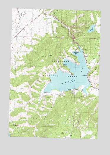
Georgetown Lake, MT USGS Topographic Map
Click on map above to begin viewing in our Map Viewer.

This topographic map contains these locations and features:
Feature Name Type Latitude Longitude GNIS ID View Map
Badger Bay CampgroundLocaleN46.1885°W113.3014°794155View Map
Bimetallic Power PlantLocaleN46.2269°W113.2945°798896View Map
Blodgett GulchValleyN46.1655°W113.3114°780119View Map
Campfire Girls CampLocaleN46.2016°W113.3026°794153View Map
Comers Point Picnic AreaLocaleN46.1802°W113.3178°794160View Map
Dentons PointCapeN46.1730°W113.2887°782304View Map
Dentons Point CampgroundLocaleN46.1727°W113.2862°1786462View Map
Dry CreekStreamN46.1663°W113.2523°782577View Map
Eccelston Boat DocksLocaleN46.1838°W113.3206°794159View Map
Echo LakeLakeN46.2321°W113.2631°782970View Map
Echo Lake (historical)Populated PlaceN46.2333°W113.2676°1781825View Map
Echo Lake CampgroundLocaleN46.2310°W113.2695°794151View Map
Fessler SpringSpringN46.2452°W113.3281°783365View Map
Flint Creek CampgroundLocaleN46.2335°W113.3003°783543View Map
Flint Creek DamDamN46.2149°W113.2809°783545View Map
Georgetown LakeReservoirN46.1856°W113.2910°783903View Map
Georgetown Lake DamDamN46.2133°W113.2809°795209View Map
Georgetown Lake Volunteer Fire Company Station 1BuildingN46.1948°W113.2578°2546636View Map
Georgetown Lake Volunteer Fire Company Station 2BuildingN46.1943°W113.3044°2546510View Map
Grassy Boat LaunchLocaleN46.1833°W113.2673°807080View Map
Haggin Dude RanchLocaleN46.1580°W113.3126°794158View Map
Jericho Bay CampgroundLocaleN46.1688°W113.3231°794157View Map
Little Trout CreekStreamN46.2355°W113.3623°786388View Map
Lodgepole CampgroundLocaleN46.2119°W113.2734°786427View Map
Lost Track MineMineN46.1813°W113.2828°803170View Map
North Fork Flint CreekStreamN46.1966°W113.2687°788166View Map
Pebble Beach CampgroundLocaleN46.2102°W113.2845°807079View Map
Peterson MeadowFlatN46.1252°W113.2923°788795View Map
Philipsburg BayBayN46.2083°W113.2848°788814View Map
Philipsburg Bay CampgroundLocaleN46.2063°W113.2909°794152View Map
Piney CampgroundLocaleN46.1960°W113.3023°788907View Map
Piney PointCapeN46.1871°W113.2878°788911View Map
Piney Point CampgroundLocaleN46.1869°W113.2870°794156View Map
Rainbow Bay CampgroundLocaleN46.2013°W113.2942°794154View Map
Red Bridge Boat LaunchLocaleN46.2096°W113.2751°807078View Map
Roberts Landing (historical)LocaleN46.1888°W113.2662°1786386View Map
Sandy Beach CampgroundLocaleN46.1758°W113.3281°794161View Map
Sawmill CreekStreamN46.2438°W113.3203°790058View Map
Stuart CampgroundLocaleN46.1799°W113.2634°807081View Map
Stuart Mill Bay CampgroundLocaleN46.1763°W113.2723°807082View Map
Stuart Mill SpringSpringN46.1658°W113.2701°791614View Map
Travlers Home CreekStreamN46.2399°W113.3198°792360View Map
Twilight MineMineN46.2083°W113.2509°802816View Map

Note: Coordinates in the location and feature list above are referenced to NAD83 datum.


Copyright (C) 2008-2024 Ryan Niemi / Sunset Dynamics ... All Rights Reserved