TopoQuest Logo
Do you find TopoQuest useful?
Help keep TopoQuest running and adding new maps/features by donating!
Bitcoin:  19c7KJd3qBynnjoSw5npx9KScwjBe4ifkT
Litecoin:  LXs6TkuXGGXo1vDsWCkWVdjQX94eUKd6ui
Home View Maps Find Maps Find Places Resources & Links


Carpp Ridge, Montana Topographic Map

USGS Map Title: Carpp Ridge, MT
USGS Map MRC: 46113A4
DRG (GeoTIFF) Download: o46113a4.tif


Neighboring USGS Topographic Map Quads:


  Maukey Gulch, MT  
46113B5
 

  Potato Lakes, MT  
46113B4
 

  Georgetown Lake, MT  
46113B3
 

  Moose Lake, MT  
46113A5
 

  Carpp Ridge, MT  
46113A4
 

  Storm Lake, MT  
46113A3
 

  Kelly Lake, MT  
45113H5
 

  Warren Peak, MT  
45113H4
 

  Long Peak, MT  
45113H3


Map MRC Location:

N47°
W114°
N47°
W113°
H8 H7 H6 H5 H4 H3 H2 H1
G8 G7 G6 G5 G4 G3 G2 G1
F8 F7 F6 F5 F4 F3 F2 F1
E8 E7 E6 E5 E4 E3 E2 E1
D8 D7 D6 D5 D4 D3 D2 D1
C8 C7 C6 C5 C4 C3 C2 C1
B8 B7 B6 B5 B4 B3 B2 B1
A8 A7 A6 A5 A4 A3 A2 A1
N46°
W114°
N46°
W113°

Carpp Ridge, MT USGS 1:24K Topographic Map Preview:
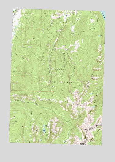
Carpp Ridge, MT USGS Topographic Map
Click on map above to begin viewing in our Map Viewer.

This topographic map contains these locations and features:
Feature Name Type Latitude Longitude GNIS ID View Map
Beaverhead MountainSummitN46.0005°W113.3990°779635View Map
Big Spring CreekStreamN46.0935°W113.4445°779878View Map
Blue Grotto SpringSpringN46.1032°W113.4174°780146View Map
Carpp LakeLakeN46.0120°W113.4537°806279View Map
Carpp MineMineN46.0391°W113.4328°780967View Map
Carpp RidgeRidgeN46.0416°W113.4334°780968View Map
Dexter BasinBasinN46.0541°W113.4109°782343View Map
Dexter CreekStreamN46.0877°W113.4381°782344View Map
George LakeLakeN46.1020°W113.3833°783896View Map
Lower Carpp LakeLakeN46.0166°W113.4541°806283View Map
Maloney BasinValleyN46.0130°W113.4181°786802View Map
McDougal GulchValleyN46.1202°W113.4323°787039View Map
Porter RidgeRidgeN46.0044°W113.4837°789121View Map
Sauer LakeLakeN46.0360°W113.3876°790032View Map
Spruce LakeLakeN46.0477°W113.3918°791343View Map
SW SW Section 25 MineMineN46.0669°W113.4134°803184View Map
Tamarack CreekStreamN46.0377°W113.4817°791875View Map

Note: Coordinates in the location and feature list above are referenced to NAD83 datum.


Copyright (C) 2008-2024 Ryan Niemi / Sunset Dynamics ... All Rights Reserved