TopoQuest Logo
Do you find TopoQuest useful?
Help keep TopoQuest running and adding new maps/features by donating!
Bitcoin:  19c7KJd3qBynnjoSw5npx9KScwjBe4ifkT
Litecoin:  LXs6TkuXGGXo1vDsWCkWVdjQX94eUKd6ui
Home View Maps Find Maps Find Places Resources & Links


Germania, Wisconsin Topographic Map

USGS Map Title: Germania, WI
USGS Map MRC: 43089H3
DRG (GeoTIFF) Download: o43089h3.tif


Neighboring USGS Topographic Map Quads:


  Richford, WI  
44089A4
 

  Wautoma, WI  
44089A3
 

  Spring Lake, WI  
44089A2
 

  Westfield East, WI  
43089H4
 

  Germania, WI  
43089H3
 

  Neshkoro, WI  
43089H2
 

  Packwaukee, WI  
43089G4
 

  Montello, WI  
43089G3
 

  Princeton West, WI  
43089G2


Map MRC Location:

N44°
W90°
N44°
W89°
H8 H7 H6 H5 H4 H3 H2 H1
G8 G7 G6 G5 G4 G3 G2 G1
F8 F7 F6 F5 F4 F3 F2 F1
E8 E7 E6 E5 E4 E3 E2 E1
D8 D7 D6 D5 D4 D3 D2 D1
C8 C7 C6 C5 C4 C3 C2 C1
B8 B7 B6 B5 B4 B3 B2 B1
A8 A7 A6 A5 A4 A3 A2 A1
N43°
W90°
N43°
W89°

Germania, WI USGS 1:24K Topographic Map Preview:
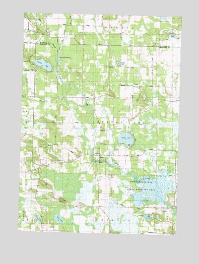
Germania, WI USGS Topographic Map
Click on map above to begin viewing in our Map Viewer.

This topographic map contains these locations and features:
Feature Name Type Latitude Longitude GNIS ID View Map
155 ReservoirReservoirN43.8950°W89.2601°1792860View Map
BudsinPopulated PlaceN43.9194°W89.3121°1562348View Map
Chaffee CreekStreamN43.9478°W89.3215°1562917View Map
Comstock Bog-Meadow State Natural AreaParkN43.8805°W89.2929°2054855View Map
Comstock LakeLakeN43.8853°W89.2734°1563306View Map
Crystal LakeLakeN43.9706°W89.3587°1563584View Map
DakotaPopulated PlaceN43.9903°W89.3565°1563668View Map
Emmanuel Evangelical Crystal Lake CemeteryCemeteryN43.9275°W89.3118°1840262View Map
GermaniaPopulated PlaceN43.8905°W89.2571°1565491View Map
Germania 2wp1344 DamDamN43.8950°W89.2601°1792859View Map
Germania Marsh State Wildlife AreaParkN43.9041°W89.2718°1565493View Map
Germania Wet Prairie State Natural AreaParkN43.8991°W89.2912°2054856View Map
Lake of the WoodsReservoirN43.9741°W89.3461°1837630View Map
Lang G 781.4 DamDamN43.9716°W89.3468°1792192View Map
Little Pine CreekStreamN43.9711°W89.3471°1568356View Map
Little Pine Pond 20ReservoirN43.9716°W89.3468°1792193View Map
Lucky LakeLakeN43.9892°W89.2569°1568787View Map
Matz-Tagatz CemeteryCemeteryN43.9083°W89.3054°1569131View Map
Mount PisgahSummitN43.9544°W89.3039°2760577View Map
Mud LakeLakeN43.8827°W89.3432°1569920View Map
Mud LakeLakeN43.8852°W89.2648°2784547View Map
Needham PondLakeN43.9496°W89.2730°2784548View Map
Saint Johns ChurchChurchN43.9200°W89.3126°1837624View Map
Saint Johns Lutheran CemeteryCemeteryN43.9200°W89.3132°1840265View Map
Saint Paul Lutheran CemeteryCemeteryN43.9669°W89.3659°1840267View Map
Sandy LakeLakeN43.9724°W89.2990°1573722View Map
Silver LakeLakeN43.8823°W89.3595°1574131View Map
Stone ChurchChurchN43.9672°W89.3654°1574917View Map
Stone HillSummitN43.8930°W89.3401°1574918View Map
Town of Crystal LakeCivilN43.9387°W89.3060°1583033View Map
Tuttle LakeLakeN43.9293°W89.2915°1575752View Map
United Brethren ChurchChurchN43.9266°W89.3098°1575918View Map
Wedde CreekStreamN43.9503°W89.3562°1576391View Map
Wilcox E1423 DamDamN43.9983°W89.2635°1792520View Map
Wilcox G2982 DamDamN44.0000°W89.2718°1793249View Map

Note: Coordinates in the location and feature list above are referenced to NAD83 datum.


Copyright (C) 2008-2024 Ryan Niemi / Sunset Dynamics ... All Rights Reserved