TopoQuest Logo
Do you find TopoQuest useful?
Help keep TopoQuest running and adding new maps/features by donating!
Bitcoin:  19c7KJd3qBynnjoSw5npx9KScwjBe4ifkT
Litecoin:  LXs6TkuXGGXo1vDsWCkWVdjQX94eUKd6ui
Home View Maps Find Maps Find Places Resources & Links


Neshkoro, Wisconsin Topographic Map

USGS Map Title: Neshkoro, WI
USGS Map MRC: 43089H2
DRG (GeoTIFF) Download: o43089h2.tif


Neighboring USGS Topographic Map Quads:


  Wautoma, WI  
44089A3
 

  Spring Lake, WI  
44089A2
 

  Redgranite, WI  
44089A1
 

  Germania, WI  
43089H3
 

  Neshkoro, WI  
43089H2
 

  Fairburn, WI  
43089H1
 

  Montello, WI  
43089G3
 

  Princeton West, WI  
43089G2
 

  Princeton East, WI  
43089G1


Map MRC Location:

N44°
W90°
N44°
W89°
H8 H7 H6 H5 H4 H3 H2 H1
G8 G7 G6 G5 G4 G3 G2 G1
F8 F7 F6 F5 F4 F3 F2 F1
E8 E7 E6 E5 E4 E3 E2 E1
D8 D7 D6 D5 D4 D3 D2 D1
C8 C7 C6 C5 C4 C3 C2 C1
B8 B7 B6 B5 B4 B3 B2 B1
A8 A7 A6 A5 A4 A3 A2 A1
N43°
W90°
N43°
W89°

Neshkoro, WI USGS 1:24K Topographic Map Preview:
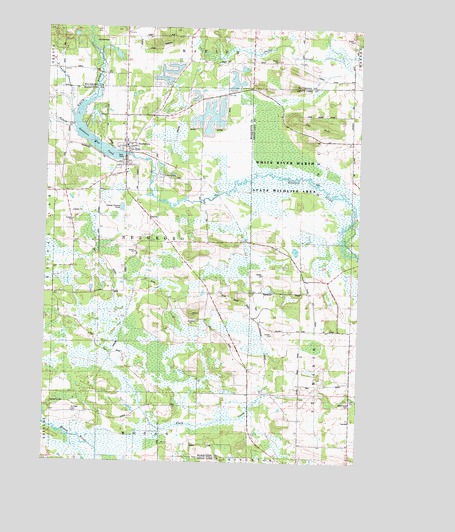
Neshkoro, WI USGS Topographic Map
Click on map above to begin viewing in our Map Viewer.

This topographic map contains these locations and features:
Feature Name Type Latitude Longitude GNIS ID View Map
BannermanPopulated PlaceN43.9966°W89.2251°1577503View Map
Bannerman LakeLakeN43.9918°W89.2221°2784586View Map
Black Creek CemeteryCemeteryN43.8920°W89.1272°1561857View Map
Germania CemeteryCemeteryN43.8922°W89.2471°1565492View Map
Little Lunch CreekStreamN43.9755°W89.2398°1568308View Map
Lunch CreekStreamN43.9725°W89.2387°1568804View Map
NeshkoroPopulated PlaceN43.9658°W89.2176°1570185View Map
Neshkoro Area Fire Protection DistrictBuildingN43.9582°W89.2179°2697753View Map
Neshkoro DamDamN43.9633°W89.2185°1791962View Map
Neshkoro Elementary SchoolSchoolN43.9660°W89.2181°1837621View Map
Neshkoro Mill PondReservoirN43.9669°W89.2306°1791963View Map
Neshkoro Police DepartmentBuildingN43.9610°W89.2184°2759954View Map
Neshkoro Village CemeteryCemeteryN43.9677°W89.2193°2781241View Map
Pine BluffCliffN43.9728°W89.1426°1571417View Map
Rabbit School (historical)SchoolN43.9678°W89.1260°1572009View Map
Rodney (historical)Populated PlaceN43.9853°W89.1285°1845700View Map
Saint Peter CemeteryCemeteryN43.8894°W89.2384°1573504View Map
School Number 1 (historical)SchoolN43.9969°W89.2185°1845704View Map
School Number 2 (historical)SchoolN43.9158°W89.1865°1843467View Map
School Number 4 (historical)SchoolN43.9383°W89.2010°1843468View Map
School Number 7 (historical)SchoolN43.8872°W89.1485°1843800View Map
School Number 8 (historical)SchoolN43.8803°W89.2029°1843471View Map
School Number 8 (historical)SchoolN43.8930°W89.1276°1843803View Map
School Number 9 (historical)SchoolN43.9239°W89.1457°1843805View Map
Town of NeshkoroCivilN43.9362°W89.2064°1583795View Map
Village of NeshkoroCivilN43.9652°W89.2157°1583794View Map
White River Prairie-Tamaracks State Natural AreaParkN43.9619°W89.1543°2057276View Map
Zion Evangelical Lutheran CemeteryCemeteryN43.9674°W89.2180°2781240View Map

Note: Coordinates in the location and feature list above are referenced to NAD83 datum.


Copyright (C) 2008-2024 Ryan Niemi / Sunset Dynamics ... All Rights Reserved