TopoQuest Logo
Do you find TopoQuest useful?
Help keep TopoQuest running and adding new maps/features by donating!
Bitcoin:  19c7KJd3qBynnjoSw5npx9KScwjBe4ifkT
Litecoin:  LXs6TkuXGGXo1vDsWCkWVdjQX94eUKd6ui
Home View Maps Find Maps Find Places Resources & Links


Ghost Ranch, New Mexico Topographic Map

USGS Map Title: Ghost Ranch, NM
USGS Map MRC: 36106C4
DRG (GeoTIFF) Download: o36106c4.tif


Neighboring USGS Topographic Map Quads:


  Alire, NM  
36106D5
 

  Canjilon, NM  
36106D4
 

  Mogote Peak, NM  
36106D3
 

  Echo Amphitheater, NM  
36106C5
 

  Ghost Ranch, NM  
36106C4
 

  Canjilon SE, NM  
36106C3
 

  Youngsville, NM  
36106B5
 

  Canones, NM  
36106B4
 

  Abiquiu, NM  
36106B3


Map MRC Location:

N37°
W107°
N37°
W106°
H8 H7 H6 H5 H4 H3 H2 H1
G8 G7 G6 G5 G4 G3 G2 G1
F8 F7 F6 F5 F4 F3 F2 F1
E8 E7 E6 E5 E4 E3 E2 E1
D8 D7 D6 D5 D4 D3 D2 D1
C8 C7 C6 C5 C4 C3 C2 C1
B8 B7 B6 B5 B4 B3 B2 B1
A8 A7 A6 A5 A4 A3 A2 A1
N36°
W107°
N36°
W106°

Ghost Ranch, NM USGS 1:24K Topographic Map Preview:
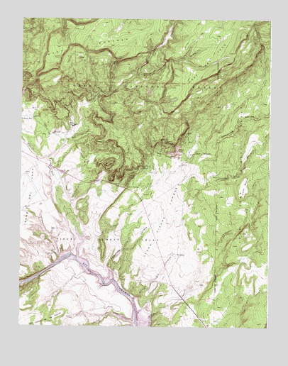
Ghost Ranch, NM USGS Topographic Map
Click on map above to begin viewing in our Map Viewer.

This topographic map contains these locations and features:
Feature Name Type Latitude Longitude GNIS ID View Map
Abiquiu ReservoirReservoirN36.2657°W106.4599°923786View Map
Arroyo de ComalesStreamN36.2550°W106.4322°903314View Map
Arroyo del ChamisoStreamN36.2625°W106.4406°903327View Map
Arroyo del YesoStreamN36.3184°W106.4867°903346View Map
Arroyo JaspeStreamN36.2522°W106.4428°903391View Map
Bull CanyonValleyN36.2881°W106.4589°2677893View Map
Canjilon CreekStreamN36.2983°W106.4761°928700View Map
Cats EyeArchN36.3100°W106.4547°2632193View Map
CCC CampLocaleN36.2956°W106.4436°904269View Map
Christ-in-the-Desert MonasteryLocaleN36.3317°W106.4731°933792View Map
Comanche CanyonValleyN36.2686°W106.4528°905276View Map
Copper Trick TankReservoirN36.2769°W106.3757°913961View Map
Dead End TankReservoirN36.3674°W106.4117°913960View Map
El Monte RojoPopulated PlaceN36.3342°W106.4945°906059View Map
Florence Hawley Ellis Museum of AnthropologyBuildingN36.3317°W106.4731°929519View Map
Ghost RanchLocaleN36.3317°W106.4731°906530View Map
Ghost Ranch Strip Airport (historical)AirportN36.3028°W106.4881°936885View Map
Ghost Ranch Weather StationLocaleN36.3317°W106.4731°932408View Map
Horny Toad MineMineN36.3606°W106.4228°917348View Map
Iron SpringSpringN36.2794°W106.4867°907257View Map
Llano BlancoAreaN36.3072°W106.3873°908083View Map
Llano Piedra LumbreAreaN36.2914°W106.4264°908092View Map
Manzanares TankReservoirN36.2652°W106.3842°913957View Map
Mesa del YesoSummitN36.3628°W106.4042°908611View Map
Mesa MontosaSummitN36.3684°W106.4750°908622View Map
Ojitos de los GatosSpringN36.3063°W106.4464°909277View Map
Piedra Lumbre GrantCivilN36.2853°W106.4492°909625View Map
Rio Chama Valley GravelsMineN36.2725°W106.4814°916723View Map
Ruth Hall Museum of PaleontologyBuildingN36.3317°W106.4731°929509View Map
Six- 13- S Ext.MineN36.3145°W106.4942°917014View Map
Trick Tank Number OneReservoirN36.3708°W106.4618°913964View Map
Trick Tank Number ThreeReservoirN36.3668°W106.4473°913959View Map
Wild Horse TankReservoirN36.3576°W106.4032°913958View Map

Note: Coordinates in the location and feature list above are referenced to NAD83 datum.


Copyright (C) 2008-2025 Ryan Niemi / Sunset Dynamics ... All Rights Reserved