TopoQuest Logo
Do you find TopoQuest useful?
Help keep TopoQuest running and adding new maps/features by donating!
Bitcoin:  19c7KJd3qBynnjoSw5npx9KScwjBe4ifkT
Litecoin:  LXs6TkuXGGXo1vDsWCkWVdjQX94eUKd6ui
Home View Maps Find Maps Find Places Resources & Links


Canones, New Mexico Topographic Map

USGS Map Title: Canones, NM
USGS Map MRC: 36106B4
DRG (GeoTIFF) Download: o36106b4.tif


Neighboring USGS Topographic Map Quads:


  Echo Amphitheater, NM  
36106C5
 

  Ghost Ranch, NM  
36106C4
 

  Canjilon SE, NM  
36106C3
 

  Youngsville, NM  
36106B5
 

  Canones, NM  
36106B4
 

  Abiquiu, NM  
36106B3
 

  Cerro del Grant, NM  
36106A5
 

  Polvadera Peak, NM  
36106A4
 

  Vallecitos, NM  
36106A3


Map MRC Location:

N37°
W107°
N37°
W106°
H8 H7 H6 H5 H4 H3 H2 H1
G8 G7 G6 G5 G4 G3 G2 G1
F8 F7 F6 F5 F4 F3 F2 F1
E8 E7 E6 E5 E4 E3 E2 E1
D8 D7 D6 D5 D4 D3 D2 D1
C8 C7 C6 C5 C4 C3 C2 C1
B8 B7 B6 B5 B4 B3 B2 B1
A8 A7 A6 A5 A4 A3 A2 A1
N36°
W107°
N36°
W106°

Canones, NM USGS 1:24K Topographic Map Preview:
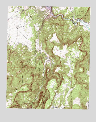
Canones, NM USGS Topographic Map
Click on map above to begin viewing in our Map Viewer.

This topographic map contains these locations and features:
Feature Name Type Latitude Longitude GNIS ID View Map
Abiquiu DamDamN36.2381°W106.4261°923785View Map
Agua Condida TrailTrailN36.1489°W106.3875°2681522View Map
Arroyo CarrerasStreamN36.2025°W106.4520°903363View Map
Arroyo SejitasStreamN36.1992°W106.4511°903423View Map
Barranca Mesa Trick TankReservoirN36.1863°W106.4023°2677826View Map
Blanca MesaSummitN36.1834°W106.4475°903910View Map
Cañada de OjitosStreamN36.1286°W106.4309°904410View Map
Cañada GonzalesStreamN36.1767°W106.4423°904454View Map
Cañoncito SecoValleyN36.1517°W106.4473°904716View Map
CañonesPopulated PlaceN36.1881°W106.4395°904721View Map
Cañones Census Designated PlaceCensusN36.1769°W106.4244°2584065View Map
Cañones CreekStreamN36.2342°W106.4447°904722View Map
Cañones Grade SchoolSchoolN36.1845°W106.4353°904723View Map
Cañones MesaSummitN36.1942°W106.4153°904724View Map
Cañones Post OfficePost OfficeN36.1881°W106.4400°938131View Map
Capilla de San MiguelChurchN36.1870°W106.4398°904743View Map
Cerro Pelon TankReservoirN36.1281°W106.3958°2677715View Map
Cerro Pelon Trick TankReservoirN36.1403°W106.3958°2677815View Map
Cerro SpringSpringN36.1811°W106.4800°2677827View Map
Chihuahueños CreekStreamN36.1334°W106.4614°905093View Map
Colanutria Trick TankReservoirN36.1500°W106.4041°2681523View Map
Colorado Plateau Historical MarkerParkN36.2400°W106.4306°932232View Map
Escoba Trick TankReservoirN36.1463°W106.4857°2677823View Map
Juan Bautista Valdez GrantCivilN36.1775°W106.4508°2677829View Map
La Joya del PedregalBenchN36.2234°W106.4895°907668View Map
Las Lomas de los MariosSummitN36.2409°W106.4770°907873View Map
Lower CañonesPopulated PlaceN36.1986°W106.4506°901583View Map
Mesa EscobaSummitN36.1481°W106.4864°908613View Map
North Sundown TankReservoirN36.1652°W106.4042°2677819View Map
Polvadera CreekStreamN36.1892°W106.4370°909782View Map
Polvadera TankReservoirN36.1475°W106.4244°2677822View Map
Pueblo MesaSummitN36.1725°W106.4356°909879View Map
Red Wash CanyonValleyN36.2270°W106.3798°910087View Map
Salazar RanchLocaleN36.2064°W106.4550°910552View Map
San Miguel CemeteryCemeteryN36.1870°W106.4442°910676View Map
Sundown TankReservoirN36.1640°W106.4037°2677820View Map
Temoline Trick TankReservoirN36.1510°W106.4818°2677824View Map
Trail SpringSpringN36.2178°W106.3947°2677828View Map
Tsiping (historical)LocaleN36.1709°W106.4381°901464View Map
Wade SpringSpringN36.1639°W106.4431°2677825View Map
West Colanutria TankReservoirN36.1508°W106.4102°2677818View Map

Note: Coordinates in the location and feature list above are referenced to NAD83 datum.


Copyright (C) 2008-2025 Ryan Niemi / Sunset Dynamics ... All Rights Reserved