TopoQuest Logo
Do you find TopoQuest useful?
Help keep TopoQuest running and adding new maps/features by donating!
Bitcoin:  19c7KJd3qBynnjoSw5npx9KScwjBe4ifkT
Litecoin:  LXs6TkuXGGXo1vDsWCkWVdjQX94eUKd6ui
Home View Maps Find Maps Find Places Resources & Links


Gibsonton, Florida Topographic Map

USGS Map Title: Gibsonton, FL
USGS Map MRC: 27082G4
DRG (GeoTIFF) Download: o27082g4.tif


Neighboring USGS Topographic Map Quads:


  Gandy Bridge, FL  
27082H5
 

  Tampa, FL  
27082H4
 

  Brandon, FL  
27082H3
 

  Port Tampa, FL  
27082G5
 

  Gibsonton, FL  
27082G4
 

  Riverview, FL  
27082G3
 

  Cockroach Bay, FL  
27082F5
 

  Ruskin, FL  
27082F4
 

  Wimauma, FL  
27082F3


Map MRC Location:

N28°
W83°
N28°
W82°
H8 H7 H6 H5 H4 H3 H2 H1
G8 G7 G6 G5 G4 G3 G2 G1
F8 F7 F6 F5 F4 F3 F2 F1
E8 E7 E6 E5 E4 E3 E2 E1
D8 D7 D6 D5 D4 D3 D2 D1
C8 C7 C6 C5 C4 C3 C2 C1
B8 B7 B6 B5 B4 B3 B2 B1
A8 A7 A6 A5 A4 A3 A2 A1
N27°
W83°
N27°
W82°

Gibsonton, FL USGS 1:24K Topographic Map Preview:
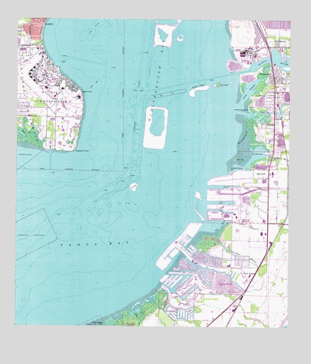
Gibsonton, FL USGS Topographic Map
Click on map above to begin viewing in our Map Viewer.

This topographic map contains these locations and features:
Feature Name Type Latitude Longitude GNIS ID View Map
AdamsvillePopulated PlaceN27.8147°W82.3840°277687View Map
AlafiaPopulated PlaceN27.8493°W82.3837°2482144View Map
Alafia RiverStreamN27.8531°W82.4004°277718View Map
Alafia River ChannelChannelN27.8336°W82.4165°307428View Map
Allendale AcresPopulated PlaceN27.8452°W82.3837°2482171View Map
AllensPopulated PlaceN27.8306°W82.3821°2482172View Map
AndaluciaPopulated PlaceN27.7763°W82.4324°2482197View Map
Apollo BeachPopulated PlaceN27.7731°W82.4076°1867110View Map
Apollo BeachBeachN27.7717°W82.4062°299070View Map
Apollo Beach Census Designated PlaceCensusN27.7618°W82.4001°2402649View Map
Apollo Beach Commerce CenterLocaleN27.7628°W82.3989°2481947View Map
Apollo Beach Elementary SchoolSchoolN27.7750°W82.4021°297778View Map
Apollo Key VillagePopulated PlaceN27.7824°W82.4268°2482214View Map
Bay VistaPopulated PlaceN27.7832°W82.4277°2481531View Map
BayhavenPopulated PlaceN27.8671°W82.4914°2481535View Map
Bayshore ReservePopulated PlaceN27.8680°W82.4920°2481551View Map
Beach Club EstatesPopulated PlaceN27.7875°W82.4199°2481561View Map
Bella MarPopulated PlaceN27.7806°W82.4306°2481580View Map
Big BendBayN27.7909°W82.4062°278628View Map
Big Bend ChannelChannelN27.8106°W82.4337°307427View Map
Bimini BayPopulated PlaceN27.7733°W82.4034°2481626View Map
BindshedlerPopulated PlaceN27.7750°W82.4132°2481627View Map
Bird IslandIslandN27.8489°W82.4079°278794View Map
BrandwoodPopulated PlaceN27.8604°W82.3772°2482597View Map
Bullfrog CreekStreamN27.8375°W82.3968°279652View Map
Capital TampaPopulated PlaceN27.8745°W82.4936°2482718View Map
Catfish PointCapeN27.8453°W82.4707°280150View Map
Cobia CayPopulated PlaceN27.7854°W82.4218°2482873View Map
Dolphin CovePopulated PlaceN27.7817°W82.4188°2482319View Map
Double Bayou PassBayN27.7503°W82.4588°281695View Map
Doyle Carlton BridgeBridgeN27.8378°W82.3790°303527View Map
Dug CreekGutN27.8261°W82.3809°281845View Map
East TampaPopulated PlaceN27.8645°W82.3801°282035View Map
Edgewater VillagePopulated PlaceN27.7696°W82.3959°2482403View Map
ELAPP Forty-Eight ParkParkN27.8744°W82.4961°2569369View Map
Flat IslandPopulated PlaceN27.7801°W82.4272°2482520View Map
FostervillePopulated PlaceN27.8700°W82.4920°2482554View Map
Gadsden ParkParkN27.8664°W82.4961°2569377View Map
Gadsden PointCapeN27.8222°W82.4732°294018View Map
Garden CityPopulated PlaceN27.8298°W82.3915°2483251View Map
GardenvillePopulated PlaceN27.8464°W82.3818°282935View Map
Gardenville BeachBeachN27.8392°W82.3934°282936View Map
GibsontonPopulated PlaceN27.8536°W82.3826°283060View Map
Gibsonton Census Designated PlaceCensusN27.8257°W82.3770°2402524View Map
Gibsonton Division (historical)CensusN27.8250°W82.4237°1935779View Map
Gibsonton on the BayPopulated PlaceN27.8513°W82.3833°2483272View Map
Gibsonton Post OfficePost OfficeN27.8406°W82.3803°2768147View Map
Golf and Sea VillagePopulated PlaceN27.7635°W82.4186°2483302View Map
Green KeyIslandN27.8184°W82.3993°283385View Map
Hillsborough BayBayN27.8672°W82.4429°284039View Map
Hillsborough ChannelChannelN27.8525°W82.4434°284040View Map
Hillsborough County Fire Rescue Station 29 Apollo BeachBuildingN27.7650°W82.4095°2131662View Map
Hillsborough County Sheriff's Office Apollo Beach Community StationBuildingN27.7721°W82.3918°2333827View Map
Hillsborough County Sheriff's Office Gibsonton Community StationBuildingN27.8413°W82.3807°2333829View Map
Hog and Hominy CoveBayN27.8300°W82.3942°284071View Map
Island CayPopulated PlaceN27.7704°W82.3992°2483612View Map
Island WalkPopulated PlaceN27.7695°W82.3965°2483617View Map
Jackson BranchGutN27.7909°W82.3926°284670View Map
Kitchen BranchStreamN27.8203°W82.3845°285151View Map
LagomarPopulated PlaceN27.7770°W82.4299°2483766View Map
LeenPopulated PlaceN27.7756°W82.4326°2483014View Map
Long BarBarN27.8489°W82.4645°285946View Map
Long ShoalBarN27.8709°W82.4651°286076View Map
Lookout PlacePopulated PlaceN27.7696°W82.3957°2483093View Map
MacDill Air Force Base Fire Station 2BuildingN27.8538°W82.4919°2644602View Map
MacDill Air Force Base Post OfficePost OfficeN27.8521°W82.4913°2485504View Map
MacDill EstatesPopulated PlaceN27.8687°W82.4914°2483132View Map
MacKinlay TerracePopulated PlaceN27.8162°W82.3840°2483135View Map
Magnolia TrailsPopulated PlaceN27.8259°W82.3793°2483159View Map
Marina VillagePopulated PlaceN27.7815°W82.4218°2483196View Map
Marquard ManorPopulated PlaceN27.8179°W82.3783°2483203View Map
McQueens Village (historical)Populated PlaceN27.7836°W82.4331°294505View Map
MeadowlawnPopulated PlaceN27.8694°W82.4922°2484239View Map
MirabayPopulated PlaceN27.7541°W82.4320°2484290View Map
Mustique BayPopulated PlaceN27.7864°W82.4241°2484346View Map
Newman BranchGutN27.7795°W82.3951°287717View Map
North RuskinPopulated PlaceN27.7648°W82.3945°287863View Map
Northpointe at BayshorePopulated PlaceN27.8703°W82.4897°2484414View Map
Old Bayshore PointPopulated PlaceN27.8715°W82.4895°2484494View Map
Palm River-Gibsonton DivisionCivilN27.8561°W82.4136°2583400View Map
Peninsula HeightsPopulated PlaceN27.8729°W82.4961°2484614View Map
Pine KeyIslandN27.8075°W82.4462°288886View Map
Pocket 84Populated PlaceN27.7819°W82.4252°2483913View Map
RemlapPopulated PlaceN27.8322°W82.3818°289636View Map
Roslyn HeightsPopulated PlaceN27.8661°W82.4914°2484137View Map
Shagos BayPopulated PlaceN27.7752°W82.4143°2484919View Map
Sims BranchGutN27.8078°W82.3909°291162View Map
South ChannelBayN27.8480°W82.3922°291357View Map
South Hillsborough Commerce CenterLocaleN27.7692°W82.3941°2482068View Map
Southshore FallsPopulated PlaceN27.7594°W82.4095°2485005View Map
Sunken IslandIslandN27.8472°W82.4156°291829View Map
Surfside EstatesPopulated PlaceN27.7879°W82.4224°2485131View Map
Surfside Estates by the BayPopulated PlaceN27.7897°W82.4210°2485132View Map
Symmes ManorPopulated PlaceN27.8316°W82.3758°2485162View Map
Symphony IslesPopulated PlaceN27.7721°W82.4272°2485163View Map
The Estates at Bayshore PointePopulated PlaceN27.8721°W82.4891°2485243View Map
The KitchenBayN27.8211°W82.3889°292163View Map
The Southpointe at BayshorePopulated PlaceN27.8697°W82.4899°2485270View Map
The Villas at AndaluciaPopulated PlaceN27.7790°W82.4300°2485276View Map
Tinker Elementary SchoolSchoolN27.8467°W82.4791°297779View Map
TrevisoPopulated PlaceN27.7769°W82.4036°2485330View Map
Tropical PinesPopulated PlaceN27.8701°W82.4962°2485343View Map
United States Air Force HospitalHospitalN27.8432°W82.4713°2094875View Map
US Air Force HospitalHospitalN27.8459°W82.4710°2481941View Map
Van EyckPopulated PlaceN27.8706°W82.4924°2485403View Map
Villa Di TrevisoPopulated PlaceN27.7748°W82.4043°2485425View Map
Whiskey Stump KeyIslandN27.8145°W82.4018°305001View Map
Wolf BranchStreamN27.7561°W82.4454°293453View Map

Note: Coordinates in the location and feature list above are referenced to NAD83 datum.


Copyright (C) 2008-2025 Ryan Niemi / Sunset Dynamics ... All Rights Reserved