TopoQuest Logo
Do you find TopoQuest useful?
Help keep TopoQuest running and adding new maps/features by donating!
Bitcoin:  19c7KJd3qBynnjoSw5npx9KScwjBe4ifkT
Litecoin:  LXs6TkuXGGXo1vDsWCkWVdjQX94eUKd6ui
Home View Maps Find Maps Find Places Resources & Links


Port Tampa, Florida Topographic Map

USGS Map Title: Port Tampa, FL
USGS Map MRC: 27082G5
DRG (GeoTIFF) Download: o27082g5.tif


Neighboring USGS Topographic Map Quads:


  Safety Harbor, FL  
27082H6
 

  Gandy Bridge, FL  
27082H5
 

  Tampa, FL  
27082H4
 

  Saint Petersburg, FL  
27082G6
 

  Port Tampa, FL  
27082G5
 

  Gibsonton, FL  
27082G4
 

  Pass-a-Grille Beach, FL  
27082F6
 

  Cockroach Bay, FL  
27082F5
 

  Ruskin, FL  
27082F4


Map MRC Location:

N28°
W83°
N28°
W82°
H8 H7 H6 H5 H4 H3 H2 H1
G8 G7 G6 G5 G4 G3 G2 G1
F8 F7 F6 F5 F4 F3 F2 F1
E8 E7 E6 E5 E4 E3 E2 E1
D8 D7 D6 D5 D4 D3 D2 D1
C8 C7 C6 C5 C4 C3 C2 C1
B8 B7 B6 B5 B4 B3 B2 B1
A8 A7 A6 A5 A4 A3 A2 A1
N27°
W83°
N27°
W82°

Port Tampa, FL USGS 1:24K Topographic Map Preview:
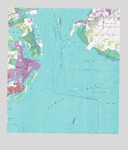
Port Tampa, FL USGS Topographic Map
Click on map above to begin viewing in our Map Viewer.

This topographic map contains these locations and features:
Feature Name Type Latitude Longitude GNIS ID View Map
Arrowhead ParkParkN27.8228°W82.6006°2566433View Map
Bay PointCapeN27.7903°W82.6157°278223View Map
Bayou GrandeBayN27.8272°W82.6002°288469View Map
Benjamin IslandIslandN27.8484°W82.5959°278481View Map
Broad CreekBayN27.8299°W82.5025°279415View Map
Butterfly LakeLakeN27.8151°W82.6081°279745View Map
Christmas IslandIslandN27.8406°W82.5940°280433View Map
Christmas PassChannelN27.8361°W82.5951°280435View Map
Coon Hammock CreekBayN27.8315°W82.5078°280753View Map
Crescent ParkPopulated PlaceN27.8710°W82.5005°2482966View Map
Denver ParkParkN27.8222°W82.6108°2566475View Map
Dewey Railroad StationLocaleN27.8720°W82.5232°300122View Map
Eden islandIslandN27.8042°W82.6137°295081View Map
Edgemoor ParkParkN27.8272°W82.6214°2566479View Map
Flora Wylie ParkParkN27.7867°W82.6236°2566482View Map
Florida Power Corporation Bartow Steam PlantLocaleN27.8599°W82.6038°2481989View Map
GandyPopulated PlaceN27.8685°W82.6161°1867143View Map
Googe IslandIslandN27.8297°W82.5976°283185View Map
Interbay PeninsulaCapeN27.8556°W82.5095°284560View Map
Jack Puryear ParkParkN27.8228°W82.6247°2566497View Map
Land Lackey EstatesPopulated PlaceN27.8747°W82.5120°2483859View Map
MacDill Air Force BaseAirportN27.8561°W82.5149°2676719View Map
Macdill Air Force BaseMilitaryN27.8472°W82.5034°2512267View Map
MacDill Air Force Base Fire DepartmentBuildingN27.8672°W82.5064°2644595View Map
MacDill Railroad StationLocaleN27.8620°W82.5170°300124View Map
Manors at ManhattanPopulated PlaceN27.8714°W82.5201°2483179View Map
Masters BayouBayN27.8591°W82.6200°286509View Map
Mermaid PointCapeN27.8225°W82.5937°286725View Map
MonnettePopulated PlaceN27.8728°W82.5079°2484304View Map
Mud Hole IslandIslandN27.8539°W82.5970°287394View Map
Northeast Presbyterian ChurchChurchN27.8126°W82.6089°2481741View Map
Palm GrovePopulated PlaceN27.8742°W82.5115°2484548View Map
Papys PointCapeN27.8303°W82.5884°288470View Map
Picnic IslandIslandN27.8534°W82.5459°288782View Map
Picnic Island CreekGutN27.8556°W82.5418°288784View Map
PinewoodPopulated PlaceN27.8696°W82.5083°2483890View Map
Placido BayouBayN27.8101°W82.6193°289018View Map
Port TampaPopulated PlaceN27.8636°W82.5268°289240View Map
Port Tampa ChannelChannelN27.8442°W82.5618°295006View Map
Port Tampa City LibraryBuildingN27.8641°W82.5279°2481261View Map
Port Tampa CommunitiesPopulated PlaceN27.8606°W82.5226°2483930View Map
Port Tampa DockHarborN27.8628°W82.5459°289241View Map
Port Tampa PointPopulated PlaceN27.8624°W82.5468°2483931View Map
Port Tampa Post OfficePost OfficeN27.8687°W82.5275°2485512View Map
Port Tampa Railroad StationLocaleN27.8620°W82.5459°300123View Map
Riviera BayBayN27.8510°W82.6172°289757View Map
Robinson HeightsPopulated PlaceN27.8704°W82.5204°2484100View Map
Robinson High SchoolSchoolN27.8736°W82.5156°297914View Map
Ross IslandIslandN27.8311°W82.5918°289981View Map
Saint Clements Episcopal ChurchChurchN27.8642°W82.5179°302089View Map
Saint Petersburg Fire and Rescue Station 12 Shore AcresBuildingN27.8215°W82.6052°2131535View Map
Saint Raphael SchoolSchoolN27.7947°W82.6179°303713View Map
Saint Thomas Episcopal ChurchChurchN27.7961°W82.6109°302900View Map
Shore AcresPopulated PlaceN27.8181°W82.6034°291075View Map
Shore Acres Elementary SchoolSchoolN27.8290°W82.6132°298864View Map
Shore Acres Mini ParkParkN27.8106°W82.6092°2566967View Map
Shore Acres ParkParkN27.8103°W82.6094°2566968View Map
Shriners Hospital for Crippled ChildrenHospitalN27.8714°W82.5045°298623View Map
Smacks BayouBayN27.8057°W82.6112°291233View Map
Snake IslandIslandN27.8450°W82.5943°291291View Map
Snell Island HarborBayN27.7956°W82.6090°291303View Map
Snell IsleIslandN27.7956°W82.6165°291304View Map
Snell Isle ParkParkN27.7964°W82.6214°2566971View Map
South Gandy ChannelChannelN27.8728°W82.6018°291381View Map
Spitler ParkPopulated PlaceN27.8700°W82.5027°2485018View Map
SunnilandPopulated PlaceN27.8685°W82.5200°2485104View Map
SunsetPopulated PlaceN27.8740°W82.5087°2485119View Map
Tampa BayBayN27.7674°W82.5816°294169View Map
Tampa Bay ChannelChannelN27.7503°W82.5832°297349View Map
Tampa Bay Community HospitalHospitalN27.8675°W82.5182°298713View Map
Tampa Fire and Rescue Station 19BuildingN27.8620°W82.5289°2481301View Map
Venetian IslesIslandN27.8172°W82.5932°295080View Map
Weedon HammockIslandN27.8556°W82.6082°292980View Map
Weedon IslandIslandN27.8453°W82.6015°292981View Map
Weedon Island State PreserveParkN27.8453°W82.6015°304172View Map
West PortPopulated PlaceN27.8704°W82.5280°2484680View Map
West Shore Elementary SchoolSchoolN27.8622°W82.5267°297913View Map
Whitted Airport Runway Extension Obstruction LightLocaleN27.7686°W82.6232°297642View Map
WLFF-AM (Saint Petersburg)TowerN27.8570°W82.6237°310136View Map
WMTX-FM (Clearwater)TowerN27.8670°W82.6240°310167View Map
WRBQ-AM (Saint Petersburg)TowerN27.8711°W82.6173°310139View Map
WTSP Radio TowerTowerN27.8711°W82.6173°295079View Map
WWRM-FM (Saint Petersburg)TowerN27.8570°W82.6237°310255View Map

Note: Coordinates in the location and feature list above are referenced to NAD83 datum.


Copyright (C) 2008-2025 Ryan Niemi / Sunset Dynamics ... All Rights Reserved