TopoQuest Logo
Do you find TopoQuest useful?
Help keep TopoQuest running and adding new maps/features by donating!
Bitcoin:  19c7KJd3qBynnjoSw5npx9KScwjBe4ifkT
Litecoin:  LXs6TkuXGGXo1vDsWCkWVdjQX94eUKd6ui
Home View Maps Find Maps Find Places Resources & Links


Giddings, Texas Topographic Map

USGS Map Title: Giddings, TX
USGS Map MRC: 30096B8
DRG (GeoTIFF) Download: o30096b8.tif


Neighboring USGS Topographic Map Quads:


  Fedor, TX  
30097C1
 

  Lincoln, TX  
30096C8
 

  Dime Box, TX  
30096C7
 

  Paige, TX  
30097B1
 

  Giddings, TX  
30096B8
 

  Ledbetter, TX  
30096B7
 

  Winchester, TX  
30097A1
 

  Warda, TX  
30096A8
 

  Nechanitz, TX  
30096A7


Map MRC Location:

N31°
W97°
N31°
W96°
H8 H7 H6 H5 H4 H3 H2 H1
G8 G7 G6 G5 G4 G3 G2 G1
F8 F7 F6 F5 F4 F3 F2 F1
E8 E7 E6 E5 E4 E3 E2 E1
D8 D7 D6 D5 D4 D3 D2 D1
C8 C7 C6 C5 C4 C3 C2 C1
B8 B7 B6 B5 B4 B3 B2 B1
A8 A7 A6 A5 A4 A3 A2 A1
N30°
W97°
N30°
W96°

Giddings, TX USGS 1:24K Topographic Map Preview:
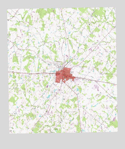
Giddings, TX USGS Topographic Map
Click on map above to begin viewing in our Map Viewer.

This topographic map contains these locations and features:
Feature Name Type Latitude Longitude GNIS ID View Map
Aubrey Area LibraryBuildingN30.1874°W96.9850°2015078View Map
Bell and Mersiovsky Ambulance ServiceBuildingN30.1822°W96.9350°2656127View Map
Betts Chapel CemeteryCemeteryN30.2319°W96.9386°1330541View Map
Big BranchStreamN30.2360°W96.8872°1330566View Map
Bullfrog CreekStreamN30.1519°W96.9691°1331628View Map
City of GiddingsCivilN30.1833°W96.9290°2410587View Map
Corinth ChurchChurchN30.2244°W96.9033°1333359View Map
Droemer Brickyard SiteLocaleN30.1727°W96.9522°2032149View Map
Frankford Village Branch LibraryBuildingN30.2194°W96.8878°2014948View Map
GiddingsPopulated PlaceN30.1827°W96.9364°1336515View Map
Giddings City HallBuildingN30.1808°W96.9375°2753691View Map
Giddings DivisionCivilN30.1697°W96.9258°1938778View Map
Giddings Elementary SchoolSchoolN30.1783°W96.9294°2007883View Map
Giddings Intermediate SchoolSchoolN30.1755°W96.9266°2007885View Map
Giddings Police DepartmentBuildingN30.1803°W96.9371°2739179View Map
Giddings Post OfficePost OfficeN30.1828°W96.9354°2732366View Map
Giddings Volunteer Fire DepartmentBuildingN30.1804°W96.9376°2552263View Map
Giddings-Lee County AirportAirportN30.1701°W96.9792°1384799View Map
Goacher Cemetery Historical SiteCemeteryN30.1291°W96.9475°1336602View Map
Hockel BranchStreamN30.2138°W96.9575°1337862View Map
Hog BranchStreamN30.1283°W96.9347°1337874View Map
Kasper Estate LakeReservoirN30.1275°W96.9155°1865448View Map
Kasper Estate Lake DamDamN30.1269°W96.9153°1865447View Map
Keng CemeteryCemeteryN30.2166°W96.9600°1339033View Map
Knox Learning CenterSchoolN30.1755°W96.8936°2007851View Map
Lee County Constable's Office Precinct 1BuildingN30.1814°W96.9371°2739337View Map
Lee County Constable's Office Precinct 2BuildingN30.1814°W96.9371°2739386View Map
Lee County Law Enforcement Center Sheriff's OfficeBuildingN30.1656°W96.9444°2739246View Map
Lee County MuseumBuildingN30.1794°W96.9355°2014554View Map
Little Bullfrog CreekStreamN30.1710°W96.9892°1340039View Map
Little Hickory CreekStreamN30.2141°W96.8928°1340113View Map
Long BranchStreamN30.2288°W96.9900°1374689View Map
Mantzel DamDamN30.1669°W96.9203°1859494View Map
Mantzel LakeReservoirN30.1684°W96.9208°1859495View Map
Meier BranchStreamN30.2402°W96.9817°1341342View Map
Noack CemeteryCemeteryN30.1302°W96.9786°1342633View Map
Oil BranchStreamN30.1311°W96.9525°1343083View Map
Pilgrims Rest ChurchChurchN30.1772°W96.9022°1344007View Map
Powell LakeReservoirN30.1377°W96.8794°1865456View Map
Powell Lake DamDamN30.1369°W96.8803°1865455View Map
Schilling BranchStreamN30.2263°W96.9980°1346764View Map
Schubert HouseBuildingN30.1819°W96.9366°2032641View Map
Seales LakesLakeN30.1666°W96.9497°1346847View Map
SerbinPopulated PlaceN30.1277°W96.9989°1379053View Map
Sievert LakeReservoirN30.1835°W96.9973°1859497View Map
Sievert Lake DamDamN30.1835°W96.9953°1859496View Map
Star of Hope Mission LakeReservoirN30.1552°W96.8753°1864497View Map
Star of Hope Mission Lake DamDamN30.1552°W96.8753°1864496View Map
Walter Droemer LakeReservoirN30.1627°W96.9540°1859493View Map
Walter Droemer Lake DamDamN30.1602°W96.9553°1859492View Map
Willow BranchStreamN30.2363°W96.8930°1350169View Map
Willy BranchStreamN30.2291°W96.9172°1350242View Map
Wolf BranchStreamN30.1499°W96.9586°1350451View Map

Note: Coordinates in the location and feature list above are referenced to NAD83 datum.


Copyright (C) 2008-2024 Ryan Niemi / Sunset Dynamics ... All Rights Reserved