TopoQuest Logo
Do you find TopoQuest useful?
Help keep TopoQuest running and adding new maps/features by donating!
Bitcoin:  19c7KJd3qBynnjoSw5npx9KScwjBe4ifkT
Litecoin:  LXs6TkuXGGXo1vDsWCkWVdjQX94eUKd6ui
Home View Maps Find Maps Find Places Resources & Links


Dime Box, Texas Topographic Map

USGS Map Title: Dime Box, TX
USGS Map MRC: 30096C7
DRG (GeoTIFF) Download: o30096c7.tif


Neighboring USGS Topographic Map Quads:


  Tanglewood, TX  
30096D8
 

  Deanville, TX  
30096D7
 

  Frenstat, TX  
30096D6
 

  Lincoln, TX  
30096C8
 

  Dime Box, TX  
30096C7
 

  Flag Pond, TX  
30096C6
 

  Giddings, TX  
30096B8
 

  Ledbetter, TX  
30096B7
 

  Carmine, TX  
30096B6


Map MRC Location:

N31°
W97°
N31°
W96°
H8 H7 H6 H5 H4 H3 H2 H1
G8 G7 G6 G5 G4 G3 G2 G1
F8 F7 F6 F5 F4 F3 F2 F1
E8 E7 E6 E5 E4 E3 E2 E1
D8 D7 D6 D5 D4 D3 D2 D1
C8 C7 C6 C5 C4 C3 C2 C1
B8 B7 B6 B5 B4 B3 B2 B1
A8 A7 A6 A5 A4 A3 A2 A1
N30°
W97°
N30°
W96°

Dime Box, TX USGS 1:24K Topographic Map Preview:
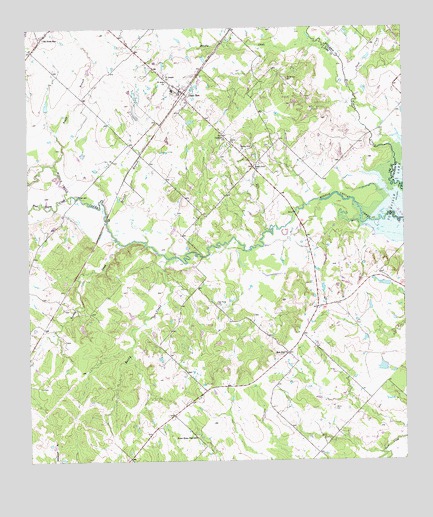
Dime Box, TX USGS Topographic Map
Click on map above to begin viewing in our Map Viewer.

This topographic map contains these locations and features:
Feature Name Type Latitude Longitude GNIS ID View Map
Antioch ChurchChurchN30.2791°W96.7753°1329600View Map
Beat Five ChurchChurchN30.2808°W96.7886°1330264View Map
Boggy BranchStreamN30.3358°W96.8661°1372657View Map
Brushy BranchStreamN30.3135°W96.8358°1331411View Map
Brushy CreekStreamN30.3710°W96.7786°1372767View Map
Bush BranchStreamN30.3355°W96.8700°1372853View Map
Dime BoxPopulated PlaceN30.3566°W96.8225°1334366View Map
Dime Box Post OfficePost OfficeN30.3560°W96.8246°2731945View Map
Fairview High SchoolSchoolN30.3469°W96.7955°1335647View Map
Gerdes Lake Number 1ReservoirN30.2755°W96.7571°1859505View Map
Gerdes Lake Number 1 DamDamN30.2752°W96.7569°1859504View Map
Goodwill ChurchChurchN30.3435°W96.8089°1336718View Map
High Prairie CemeteryCemeteryN30.2952°W96.8122°1337717View Map
Rising Star ChurchChurchN30.3399°W96.8033°1345254View Map
Rocky CreekStreamN30.3085°W96.8278°1345446View Map
Saint John ChurchChurchN30.3597°W96.8283°1345928View Map
Saint Joseph ChurchChurchN30.3613°W96.8289°1345965View Map
Salem CemeteryCemeteryN30.2649°W96.7739°1346159View Map
Sand CreekStreamN30.3566°W96.7666°1375986View Map
Sandy Point CemeteryCemeteryN30.3602°W96.7880°1346606View Map
Sandy Point ChurchChurchN30.3355°W96.7986°1346607View Map
Smith LakeReservoirN30.3526°W96.8689°1865444View Map
Smith Lake DamDamN30.3519°W96.8686°1865443View Map
Somerville Wildlife Management AreaParkN30.3327°W96.7550°2029285View Map
Sweet HomePopulated PlaceN30.2574°W96.8214°2034714View Map
Sweet Home High SchoolSchoolN30.2569°W96.8200°1348131View Map
Turkey CreekStreamN30.3127°W96.8436°1348867View Map
Vickle ChurchChurchN30.3424°W96.8066°1349264View Map
West Yegua CreekStreamN30.3272°W96.8605°1349850View Map

Note: Coordinates in the location and feature list above are referenced to NAD83 datum.


Copyright (C) 2008-2025 Ryan Niemi / Sunset Dynamics ... All Rights Reserved