TopoQuest Logo
Do you find TopoQuest useful?
Help keep TopoQuest running and adding new maps/features by donating!
Bitcoin:  19c7KJd3qBynnjoSw5npx9KScwjBe4ifkT
Litecoin:  LXs6TkuXGGXo1vDsWCkWVdjQX94eUKd6ui
Home View Maps Find Maps Find Places Resources & Links


Gideon, Missouri Topographic Map

USGS Map Title: Gideon, MO
USGS Map MRC: 36089D8
DRG (GeoTIFF) Download: o36089d8.tif


Neighboring USGS Topographic Map Quads:


  Valley Ridge, MO  
36090E1
 

  Malden, MO  
36089E8
 

  Parma, MO  
36089E7
 

  Campbell, MO  
36090D1
 

  Gideon, MO  
36089D8
 

  Boekerton, MO  
36089D7
 

  Kennett North, MO  
36090C1
 

  Bragg City, MO  
36089C8
 

  Wardell, MO  
36089C7


Map MRC Location:

N37°
W90°
N37°
W89°
H8 H7 H6 H5 H4 H3 H2 H1
G8 G7 G6 G5 G4 G3 G2 G1
F8 F7 F6 F5 F4 F3 F2 F1
E8 E7 E6 E5 E4 E3 E2 E1
D8 D7 D6 D5 D4 D3 D2 D1
C8 C7 C6 C5 C4 C3 C2 C1
B8 B7 B6 B5 B4 B3 B2 B1
A8 A7 A6 A5 A4 A3 A2 A1
N36°
W90°
N36°
W89°

Gideon, MO USGS 1:24K Topographic Map Preview:
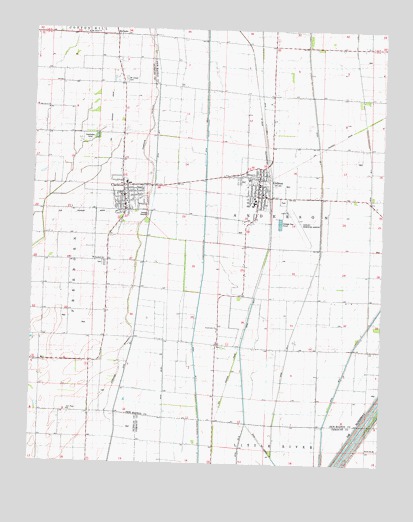
Gideon, MO USGS Topographic Map
Click on map above to begin viewing in our Map Viewer.

This topographic map contains these locations and features:
Feature Name Type Latitude Longitude GNIS ID View Map
City of ClarktonCivilN36.4520°W89.9681°2393546View Map
City of GideonCivilN36.4489°W89.9128°2394892View Map
ClarktonPopulated PlaceN36.4517°W89.9670°731555View Map
Clarkton Post OfficePost OfficeN36.4520°W89.9676°2783116View Map
Clarkton Volunteer Fire DepartmentBuildingN36.4495°W89.9675°2621522View Map
Crossroads ChurchChurchN36.4140°W89.9329°716532View Map
Ditch Number 1CanalN36.4970°W89.9570°755052View Map
Ditch Number 258CanalN36.3840°W89.8795°755088View Map
Ditch Number 293CanalN36.3756°W89.9115°755092View Map
Ditch Number 4CanalN36.4684°W89.8981°755110View Map
Douglas Grove Church (historical)ChurchN36.4265°W89.9873°741678View Map
DunnPopulated PlaceN36.4095°W89.9337°739550View Map
GideonPopulated PlaceN36.4520°W89.9193°718432View Map
Gideon Memorial AirportAirportN36.4471°W89.9086°758693View Map
Gideon Post OfficePost OfficeN36.4552°W89.9189°2782783View Map
Gideon Volunteer Fire DepartmentBuildingN36.4549°W89.9193°2620963View Map
GlendalePopulated PlaceN36.4106°W89.9056°740382View Map
Hedgerow SchoolSchoolN36.4117°W89.9720°746742View Map
Little Walnut School (historical)SchoolN36.4951°W89.9154°746745View Map
Little Walnut School (historical)SchoolN36.4670°W89.9143°746746View Map
Main DitchCanalN36.4509°W89.9945°721766View Map
Main Ditch District Number 17CanalN36.4889°W89.9931°755295View Map
MarlowPopulated PlaceN36.3898°W89.9790°730271View Map
Marlow Chapel (historical)ChurchN36.3901°W89.9856°741679View Map
Marlow School (historical)SchoolN36.3901°W89.9862°746743View Map
McBride School (historical)SchoolN36.4087°W89.8973°746748View Map
McGuirePopulated PlaceN36.4981°W89.9706°722120View Map
Miller School (historical)SchoolN36.4220°W89.9954°746741View Map
MoarkPopulated PlaceN36.3826°W89.9890°740075View Map
Mount Gilead CemeteryCemeteryN36.4853°W89.9673°722750View Map
Mount Gilead ChurchChurchN36.4988°W89.9816°730157View Map
New Hope ChurchChurchN36.3901°W89.9862°723238View Map
Oak Grove CemeteryCemeteryN36.4764°W89.9970°741676View Map
Oak Grove ChurchChurchN36.4767°W89.9951°723575View Map
Oak Grove School (historical)SchoolN36.4662°W89.9945°741677View Map
PagePopulated PlaceN36.4862°W89.9706°740383View Map
Peanut School (historical)SchoolN36.4226°W89.9043°746747View Map
SarffLocaleN36.4895°W89.9223°740080View Map
Stanfield CemeteryCemeteryN36.4326°W89.9756°746740View Map
Stanfield ChurchChurchN36.4337°W89.9779°727003View Map
Stanfield General Church (historical)ChurchN36.4076°W89.8968°741680View Map
Sweetwater CampLocaleN36.4684°W89.9826°727385View Map
Township of AndersonCivilN36.4474°W89.9036°767059View Map
Township of FreebornCivilN36.4408°W89.9914°766638View Map
Union Grove Church (historical)ChurchN36.3948°W89.9737°730270View Map
WrightsvillePopulated PlaceN36.4731°W89.9959°740384View Map
Wrightsville Post Office (historical)Post OfficeN36.4731°W89.9959°759748View Map
Zion SchoolSchoolN36.3892°W89.9856°746744View Map

Note: Coordinates in the location and feature list above are referenced to NAD83 datum.


Copyright (C) 2008-2024 Ryan Niemi / Sunset Dynamics ... All Rights Reserved