TopoQuest Logo
Do you find TopoQuest useful?
Help keep TopoQuest running and adding new maps/features by donating!
Bitcoin:  19c7KJd3qBynnjoSw5npx9KScwjBe4ifkT
Litecoin:  LXs6TkuXGGXo1vDsWCkWVdjQX94eUKd6ui
Home View Maps Find Maps Find Places Resources & Links


Gilbert, South Carolina Topographic Map

USGS Map Title: Gilbert, SC
USGS Map MRC: 33081H4
DRG (GeoTIFF) Download: o33081h4.tif


Neighboring USGS Topographic Map Quads:


  Delmar, SC  
34081A5
 

  Lake Murray West, SC  
34081A4
 

  Lake Murray East, SC  
34081A3
 

  Batesburg, SC  
33081H5
 

  Gilbert, SC  
33081H4
 

  Barr Lake, SC  
33081H3
 

  Monetta, SC  
33081G5
 

  Steedman, SC  
33081G4
 

  Pelion West, SC  
33081G3


Map MRC Location:

N34°
W82°
N34°
W81°
H8 H7 H6 H5 H4 H3 H2 H1
G8 G7 G6 G5 G4 G3 G2 G1
F8 F7 F6 F5 F4 F3 F2 F1
E8 E7 E6 E5 E4 E3 E2 E1
D8 D7 D6 D5 D4 D3 D2 D1
C8 C7 C6 C5 C4 C3 C2 C1
B8 B7 B6 B5 B4 B3 B2 B1
A8 A7 A6 A5 A4 A3 A2 A1
N33°
W82°
N33°
W81°

Gilbert, SC USGS 1:24K Topographic Map Preview:
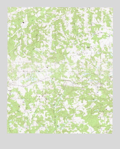
Gilbert, SC USGS Topographic Map
Click on map above to begin viewing in our Map Viewer.

This topographic map contains these locations and features:
Feature Name Type Latitude Longitude GNIS ID View Map
Ansel Smith PondReservoirN33.8810°W81.4765°1237820View Map
Camp Branch SchoolSchoolN33.8882°W81.4218°1221242View Map
Caney BranchStreamN33.9779°W81.4826°1221319View Map
Caney Branch SchoolSchoolN33.9588°W81.4907°1221323View Map
Cedar Grove Lutheran ChurchChurchN33.9857°W81.4595°1244119View Map
Cedar Grove SchoolSchoolN33.9865°W81.4590°1221460View Map
Centerville SchoolSchoolN33.9576°W81.3968°1221485View Map
Clubhouse CrossroadsPopulated PlaceN33.9601°W81.4020°1247326View Map
Crapps Mill (historical)LocaleN33.9346°W81.4476°1244144View Map
Derrick CemeteryCemeteryN33.9829°W81.4812°1244160View Map
Ebenezer ChurchChurchN33.8804°W81.4618°1247614View Map
Enon Lutheran ChurchChurchN33.8885°W81.4712°1247674View Map
FredoniaPopulated PlaceN33.9274°W81.4620°1227901View Map
GilbertPopulated PlaceN33.9243°W81.3937°1245735View Map
Gilbert DivisionCivilN33.9162°W81.3987°1938277View Map
Gilbert Elementary SchoolSchoolN33.9213°W81.3923°1244178View Map
Gilbert High SchoolSchoolN33.9160°W81.3926°1244179View Map
Gilbert International AirparkAirportN33.8831°W81.3837°1251899View Map
Gilbert Post OfficePost OfficeN33.9219°W81.4001°1244180View Map
Hayes PondReservoirN33.9535°W81.3759°1237789View Map
Highland PondReservoirN33.9093°W81.3751°1223177View Map
Hollow Creek ChurchChurchN33.9999°W81.4029°1223228View Map
Hollow Creek SchoolSchoolN33.9851°W81.4020°1223229View Map
Jumpers PondsReservoirN33.9739°W81.3984°1223677View Map
Keisler PondReservoirN33.9335°W81.3912°1223699View Map
Lexington County Fire Service Gilbert - SummittBuildingN33.9245°W81.3934°2578670View Map
Lightner - Christian CemeteryCemeteryN33.9871°W81.4420°1244266View Map
Little CreekStreamN33.9874°W81.4690°1223977View Map
Long PondReservoirN33.9274°W81.4618°1224182View Map
Mill CreekStreamN33.9021°W81.4751°1224535View Map
Mount Olive ChurchChurchN33.9851°W81.4009°1224747View Map
MurrayPopulated PlaceN33.9535°W81.4168°1231575View Map
Oak Grove School (historical)SchoolN33.9843°W81.4254°1244298View Map
Oakville SchoolSchoolN33.9849°W81.4268°1225152View Map
Old Field SchoolSchoolN33.9474°W81.4534°1225181View Map
Old Salem CemeteryCemeteryN33.9907°W81.4537°1244304View Map
Oswalds PondReservoirN33.8984°W81.3936°1237804View Map
Pleasant Hill Baptist ChurchChurchN33.9474°W81.4332°1244323View Map
Pleasant Hill ChurchChurchN33.9593°W81.4304°1250167View Map
Poplar Springs SchoolSchoolN33.8904°W81.4707°1225631View Map
PricevillePopulated PlaceN33.9988°W81.4093°1231690View Map
Providence ChurchChurchN33.8818°W81.4576°1250262View Map
Richard PondReservoirN33.9127°W81.4356°1225858View Map
Ridge Road SchoolSchoolN33.9963°W81.4857°1225878View Map
Rocky Ford CreekStreamN33.8915°W81.4768°1225979View Map
Saint James CemeteryCemeteryN33.9226°W81.4226°1244349View Map
Saint James Lutheran ChurchChurchN33.9229°W81.4220°1244353View Map
Salem Lutheran Church (historical)ChurchN33.9904°W81.4537°1244365View Map
Shealy PondReservoirN33.9026°W81.4433°1226547View Map
Shiloh CemeteryCemeteryN33.9771°W81.3757°1244383View Map
Shiloh ChurchChurchN33.9768°W81.3759°1226572View Map
Shiloh Methodist ChurchChurchN33.9774°W81.3751°1244384View Map
Smith PondReservoirN33.8814°W81.4377°1226695View Map
South Carolina Noname 32059 D-0997 DamDamN33.8985°W81.3932°1237803View Map
South Carolina Noname 32072 D-0935 DamDamN33.8818°W81.4765°1237819View Map
South Carolina Noname 32073 D-0940 DamDamN33.9079°W81.3945°1237821View Map
South Carolina Noname 32097 D-1713 DamDamN33.8835°W81.4965°1239215View Map
South Carolina Noname 32098 D-1011 DamDamN33.8851°W81.4965°1239216View Map
South Carolina Noname 32100 D-1702 DamDamN33.9568°W81.3765°1239229View Map
SummitPopulated PlaceN33.9249°W81.4220°1231844View Map
Tanker BranchStreamN33.8815°W81.4734°1227028View Map
Taylor MillpondReservoirN33.9336°W81.3764°1251126View Map
Taylor PondReservoirN33.9083°W81.3964°1251127View Map
The Farm AirportAirportN33.9359°W81.4296°2650809View Map
Town of GilbertCivilN33.9244°W81.3927°2406568View Map
Town of SummitCivilN33.9246°W81.4226°2406685View Map
WKWQ-FM (Batesburg)TowerN33.9007°W81.4068°1252443View Map

Note: Coordinates in the location and feature list above are referenced to NAD83 datum.


Copyright (C) 2008-2024 Ryan Niemi / Sunset Dynamics ... All Rights Reserved