TopoQuest Logo
Do you find TopoQuest useful?
Help keep TopoQuest running and adding new maps/features by donating!
Bitcoin:  19c7KJd3qBynnjoSw5npx9KScwjBe4ifkT
Litecoin:  LXs6TkuXGGXo1vDsWCkWVdjQX94eUKd6ui
Home View Maps Find Maps Find Places Resources & Links


Barr Lake, South Carolina Topographic Map

USGS Map Title: Barr Lake, SC
USGS Map MRC: 33081H3
DRG (GeoTIFF) Download: o33081h3.tif


Neighboring USGS Topographic Map Quads:


  Lake Murray West, SC  
34081A4
 

  Lake Murray East, SC  
34081A3
 

  Irmo, SC  
34081A2
 

  Gilbert, SC  
33081H4
 

  Barr Lake, SC  
33081H3
 

  Lexington, SC  
33081H2
 

  Steedman, SC  
33081G4
 

  Pelion West, SC  
33081G3
 

  Pelion East, SC  
33081G2


Map MRC Location:

N34°
W82°
N34°
W81°
H8 H7 H6 H5 H4 H3 H2 H1
G8 G7 G6 G5 G4 G3 G2 G1
F8 F7 F6 F5 F4 F3 F2 F1
E8 E7 E6 E5 E4 E3 E2 E1
D8 D7 D6 D5 D4 D3 D2 D1
C8 C7 C6 C5 C4 C3 C2 C1
B8 B7 B6 B5 B4 B3 B2 B1
A8 A7 A6 A5 A4 A3 A2 A1
N33°
W82°
N33°
W81°

Barr Lake, SC USGS 1:24K Topographic Map Preview:
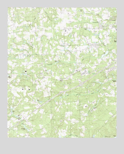
Barr Lake, SC USGS Topographic Map
Click on map above to begin viewing in our Map Viewer.

This topographic map contains these locations and features:
Feature Name Type Latitude Longitude GNIS ID View Map
Barr CrossingPopulated PlaceN33.9396°W81.2929°1244969View Map
Barr LakeReservoirN33.9555°W81.2632°1220334View Map
Boggy BranchStreamN33.9593°W81.2590°1220855View Map
Center SchoolSchoolN33.9893°W81.3548°1221478View Map
Charter Oak SchoolSchoolN33.9904°W81.3012°1221520View Map
Clamps PondReservoirN33.9618°W81.3015°1239218View Map
CreekwoodPopulated PlaceN33.9654°W81.2748°1244145View Map
Crout PondReservoirN33.8943°W81.3623°1223647View Map
Crout PondReservoirN33.9359°W81.3557°1221857View Map
ElsiePopulated PlaceN33.9321°W81.3340°1231266View Map
Ethon CrossroadsPopulated PlaceN33.9313°W81.3129°1247688View Map
Fall BranchStreamN33.9529°W81.2804°1222355View Map
Georges PondLakeN33.9660°W81.2512°1222678View Map
Gilbert Fire TowerTowerN33.8799°W81.3309°1242395View Map
Hamburg BranchStreamN33.9557°W81.3445°1222992View Map
Harmon PondReservoirN33.9971°W81.2926°1223043View Map
Hill Top ChurchChurchN33.9765°W81.3443°1244203View Map
Hogpen BranchStreamN33.9468°W81.2982°1223218View Map
Hollow Creek School (historical)SchoolN33.9963°W81.3493°1244211View Map
Interchange 51CrossingN33.9268°W81.2901°1228144View Map
Juniper CreekStreamN33.9446°W81.3318°2785817View Map
Keisler SchoolSchoolN33.9432°W81.3465°1223700View Map
Koons PondReservoirN33.8943°W81.3623°1223773View Map
Koons PondReservoirN33.8985°W81.3682°1239212View Map
Koons Pond Dam D-1703DamN33.8985°W81.3682°1239211View Map
Lake Murray Fire TowerTowerN33.9974°W81.3090°1242430View Map
Lake Shealy AnnReservoirN33.9435°W81.2715°1237826View Map
LakelandPopulated PlaceN33.9899°W81.2526°1244230View Map
Lexing-Town EstatesPopulated PlaceN33.9635°W81.2768°1244250View Map
Lexington CountyCivilN33.9023°W81.2722°1244251View Map
Lexington County Emergency Medical ServicesBuildingN33.9697°W81.2849°2739550View Map
Lexington County Fire Service Lake Murray station 15BuildingN33.9950°W81.3111°2578361View Map
Lexington County Fire Service Round HillBuildingN33.9314°W81.3054°2578832View Map
Lexington DivisionCivilN33.9750°W81.2511°1938330View Map
Lexington High SchoolSchoolN33.9776°W81.3084°1244254View Map
Lexington Medical CenterHospitalN33.9835°W81.2512°2640100View Map
Lexington Presbyterian ChurchChurchN33.9743°W81.2629°1244260View Map
Lexington Vocational Education CenterSchoolN33.9788°W81.3045°1244264View Map
Liberty Hill SchoolSchoolN33.8924°W81.3226°1223893View Map
Long BranchStreamN33.9882°W81.2651°1224125View Map
Long CreekStreamN33.9446°W81.3318°1224165View Map
Longs PondReservoirN33.9165°W81.2929°1224189View Map
Miller PondsReservoirN33.9095°W81.3368°1224570View Map
Millers PondReservoirN33.9101°W81.3348°1237785View Map
Nazareth ChurchChurchN33.9013°W81.2784°1224930View Map
Oswald PondReservoirN33.9787°W81.2819°1225252View Map
Pine BranchStreamN33.9543°W81.3498°1225430View Map
Pisgah CemeteryCemeteryN33.9613°W81.2965°1244321View Map
Pisgah Lutheran ChurchChurchN33.9610°W81.2965°1250141View Map
Pleasant Hill ChurchChurchN33.9685°W81.2951°1225545View Map
Pleasant Hill School (historical)SchoolN33.9682°W81.2943°1244324View Map
Rikards PondReservoirN33.9585°W81.3548°1237787View Map
Round Hill SchoolSchoolN33.9313°W81.3065°1226040View Map
Saint Matthews ChurchChurchN33.9399°W81.3315°1226216View Map
Smith PondReservoirN33.9479°W81.3178°1226696View Map
South Carolina Noname 32008 D-1717 DamDamN33.9590°W81.2601°1237727View Map
South Carolina Noname 32036 D-0953 DamDamN33.9268°W81.2682°1237769View Map
South Carolina Noname 32044 D-1010 DamDamN33.9968°W81.2965°1239219View Map
South Carolina Noname 32045 D-0950 DamDamN33.9771°W81.2809°1237780View Map
South Carolina Noname 32046 D-0944 DamDamN33.9485°W81.3165°1237782View Map
South Carolina Noname 32049 D-0946 DamDamN33.9101°W81.3351°1237784View Map
South Carolina Noname 32050 D-1709 DamDamN33.9585°W81.3548°1237786View Map
South Carolina Noname 32051 D-1006 DamDamN33.9518°W81.3732°1237788View Map
South Carolina Noname 32052 D-0945 DamDamN33.9351°W81.3532°1237790View Map
South Carolina Noname 32053 D-0939 DamDamN33.9351°W81.3732°1237792View Map
South Carolina Noname 32077 D-0951 DamDamN33.9435°W81.2715°1237825View Map
South Carolina Noname 32101 D-1711 DamDamN33.9618°W81.3015°1239217View Map
South Carolina Noname 32104 D-1708 DamDamN33.8751°W81.2748°1239223View Map
Spring Hill ChurchChurchN33.9735°W81.3429°1226823View Map
Turkey CreekStreamN33.9182°W81.2715°1227237View Map
Whiteplains AirportAirportN33.9635°W81.3626°2650849View Map
WLGO-AM (Lexington)TowerN33.9715°W81.2784°1252382View Map
Younginer PondReservoirN33.9045°W81.2764°1227734View Map
Zimmerman PondReservoirN33.8838°W81.3528°1253470View Map

Note: Coordinates in the location and feature list above are referenced to NAD83 datum.


Copyright (C) 2008-2024 Ryan Niemi / Sunset Dynamics ... All Rights Reserved