TopoQuest Logo
Do you find TopoQuest useful?
Help keep TopoQuest running and adding new maps/features by donating!
Bitcoin:  19c7KJd3qBynnjoSw5npx9KScwjBe4ifkT
Litecoin:  LXs6TkuXGGXo1vDsWCkWVdjQX94eUKd6ui
Home View Maps Find Maps Find Places Resources & Links


Lake Murray East, South Carolina Topographic Map

USGS Map Title: Lake Murray East, SC
USGS Map MRC: 34081A3
DRG (GeoTIFF) Download: o34081a3.tif


Neighboring USGS Topographic Map Quads:


  Little Mountain, SC  
34081B4
 

  Chapin, SC  
34081B3
 

  Richtex, SC  
34081B2
 

  Lake Murray West, SC  
34081A4
 

  Lake Murray East, SC  
34081A3
 

  Irmo, SC  
34081A2
 

  Gilbert, SC  
33081H4
 

  Barr Lake, SC  
33081H3
 

  Lexington, SC  
33081H2


Map MRC Location:

N35°
W82°
N35°
W81°
H8 H7 H6 H5 H4 H3 H2 H1
G8 G7 G6 G5 G4 G3 G2 G1
F8 F7 F6 F5 F4 F3 F2 F1
E8 E7 E6 E5 E4 E3 E2 E1
D8 D7 D6 D5 D4 D3 D2 D1
C8 C7 C6 C5 C4 C3 C2 C1
B8 B7 B6 B5 B4 B3 B2 B1
A8 A7 A6 A5 A4 A3 A2 A1
N34°
W82°
N34°
W81°

Lake Murray East, SC USGS 1:24K Topographic Map Preview:
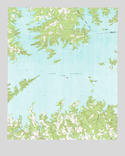
Lake Murray East, SC USGS Topographic Map
Click on map above to begin viewing in our Map Viewer.

This topographic map contains these locations and features:
Feature Name Type Latitude Longitude GNIS ID View Map
Beaverdam CreekStreamN34.0168°W81.3562°1220443View Map
Beech CreekStreamN34.0126°W81.3257°1220465View Map
Bickleys PondReservoirN34.0207°W81.2710°1237835View Map
Bundrick IslandIslandN34.0335°W81.3151°1221123View Map
Clemons BranchStreamN34.0021°W81.3357°1221630View Map
Counts IslandIslandN34.0738°W81.3187°1221773View Map
Countsville ChurchChurchN34.0888°W81.3312°1247401View Map
Dutchman ShoresPopulated PlaceN34.1246°W81.3462°1244164View Map
Eighteenmile CreekStreamN34.0343°W81.2620°1222250View Map
Hallmark ShoresPopulated PlaceN34.0210°W81.3340°1244191View Map
Harbor SidePopulated PlaceN34.0321°W81.2679°1244197View Map
Jim Spence IslandsIslandN34.0557°W81.2793°1223579View Map
Lake Murray of Richland Census Designated PlaceCensusN34.1209°W81.2653°2403200View Map
Lake PointPopulated PlaceN34.0821°W81.3240°1244228View Map
Lands EndPopulated PlaceN34.0357°W81.2798°1244234View Map
Lexington County Fire Service CrossroadsBuildingN34.1133°W81.3173°2578256View Map
Lunch IslandIslandN34.0588°W81.3098°1224232View Map
Mount Horeb ChurchChurchN34.0068°W81.2684°1224720View Map
Newberg School (historical)SchoolN34.0885°W81.3312°1244289View Map
Newberg School (historical)SchoolN34.1221°W81.3248°1244290View Map
PetersPopulated PlaceN34.0038°W81.3040°1244315View Map
Pine PointPopulated PlaceN34.0113°W81.3534°1244317View Map
ProvidencePopulated PlaceN34.0165°W81.2601°1231694View Map
Providence ChurchChurchN34.0196°W81.2634°1244328View Map
Providence School (historical)SchoolN34.0199°W81.2637°1244329View Map
Rocky CreekStreamN34.0246°W81.3395°1225975View Map
RollingwoodPopulated PlaceN34.0101°W81.2784°1244342View Map
Saint Johns ChurchChurchN34.0160°W81.3609°1226153View Map
Saint Johns School (historical)SchoolN34.0149°W81.3718°1244356View Map
Saint Peters ChurchChurchN34.0054°W81.3029°1226257View Map
Saint Thomas CemeteryCemeteryN34.1035°W81.3382°1244364View Map
Saint Thomas Lutheran ChurchChurchN34.1032°W81.3382°1250711View Map
Shady AcresPopulated PlaceN34.1015°W81.3651°1244381View Map
Shull IslandIslandN34.0538°W81.3526°1226602View Map
South Carolina Noname 32087 D-1714 DamDamN34.0218°W81.2698°1237834View Map
Stinking CreekStreamN34.1065°W81.3534°1251046View Map
Susie Ebert IslandIslandN34.1043°W81.2665°1226980View Map
Twentymile CreekStreamN34.0199°W81.3093°1227262View Map

Note: Coordinates in the location and feature list above are referenced to NAD83 datum.


Copyright (C) 2008-2024 Ryan Niemi / Sunset Dynamics ... All Rights Reserved