TopoQuest Logo
Do you find TopoQuest useful?
Help keep TopoQuest running and adding new maps/features by donating!
Bitcoin:  19c7KJd3qBynnjoSw5npx9KScwjBe4ifkT
Litecoin:  LXs6TkuXGGXo1vDsWCkWVdjQX94eUKd6ui
Home View Maps Find Maps Find Places Resources & Links


Glen Allan, Mississippi Topographic Map

USGS Map Title: Glen Allan, MS
USGS Map MRC: 33091A1
DRG (GeoTIFF) Download: o33091a1.tif


Neighboring USGS Topographic Map Quads:


  Eminence, AR  
33091B2
 

  Avon, MS  
33091B1
 

  Swan Lake NW, MS  
33090B8
 

  Readland, AR  
33091A2
 

  Glen Allan, MS  
33091A1
 

  Percy, MS  
33090A8
 

  Millikin, LA  
32091H2
 

  Mayersville, MS  
32091H1
 

  Rolling Fork West, MS  
32090H8


Map MRC Location:

N34°
W92°
N34°
W91°
H8 H7 H6 H5 H4 H3 H2 H1
G8 G7 G6 G5 G4 G3 G2 G1
F8 F7 F6 F5 F4 F3 F2 F1
E8 E7 E6 E5 E4 E3 E2 E1
D8 D7 D6 D5 D4 D3 D2 D1
C8 C7 C6 C5 C4 C3 C2 C1
B8 B7 B6 B5 B4 B3 B2 B1
A8 A7 A6 A5 A4 A3 A2 A1
N33°
W92°
N33°
W91°

Glen Allan, MS USGS 1:24K Topographic Map Preview:
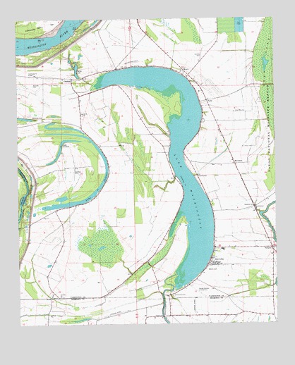
Glen Allan, MS USGS Topographic Map
Click on map above to begin viewing in our Map Viewer.

This topographic map contains these locations and features:
Feature Name Type Latitude Longitude GNIS ID View Map
AlhambraPopulated PlaceN33.0279°W91.0601°687153View Map
Allan ChapelChurchN33.0240°W91.0329°687154View Map
Byrne CityPopulated PlaceN33.0929°W91.0982°687166View Map
Byrne LakeLakeN33.1043°W91.0960°667893View Map
Carolina ChuteLakeN33.0518°W91.1223°74730View Map
ChathamPopulated PlaceN33.1007°W91.0979°668356View Map
Chatham Community Post OfficePost OfficeN33.1049°W91.0768°2768838View Map
Damascus Church (historical)ChurchN33.0940°W91.1118°687182View Map
Daniels ChapelChurchN33.0604°W91.0373°669099View Map
Eastern Star ChurchChurchN33.0715°W91.0432°687184View Map
ErwinPopulated PlaceN33.1040°W91.0437°669804View Map
Evening Star Church (historical)ChurchN33.1035°W91.0829°687191View Map
FootePopulated PlaceN33.0915°W91.0329°691864View Map
Glen AllanPopulated PlaceN33.0240°W91.0301°670427View Map
Glen Allan Attendance Center (historical)SchoolN33.0304°W91.0259°709279View Map
Glen Allan Post OfficePost OfficeN33.0252°W91.0324°2768663View Map
Guiding Star ChurchChurchN33.1029°W91.1190°670763View Map
HamptonPopulated PlaceN33.0310°W91.0020°670869View Map
Kentucky Bend RevetmentLeveeN33.1235°W91.0926°687234View Map
Lake BrittonLakeN33.0754°W91.1026°667581View Map
Lake JacksonLakeN33.0500°W91.0974°671790View Map
Lake WashingtonLakeN33.0667°W91.0468°679361View Map
Lake Washington Airport (historical)AirportN33.1073°W91.0684°680366View Map
LeotaPopulated PlaceN33.1046°W91.0762°687243View Map
Lewis AirportAirportN33.0039°W91.0402°680362View Map
Linsey (historical)Populated PlaceN33.0851°W91.0648°709286View Map
Magnolia ChurchChurchN33.0860°W91.0940°673074View Map
MarathonPopulated PlaceN33.0654°W91.0193°673123View Map
Metcalfe CemeteryCemeteryN33.0982°W91.1170°673506View Map
Minorca Nut LakeLakeN33.0847°W91.1221°673680View Map
Moore Elementary School (historical)SchoolN33.0243°W91.0270°709287View Map
Mount Holly Church (historical)ChurchN33.0873°W91.0345°711134View Map
Pleasant Star ChurchChurchN33.0993°W91.0965°687287View Map
Princeton (historical)Populated PlaceN33.0510°W91.1196°687290View Map
Princeton LandingLocaleN33.0510°W91.1212°687291View Map
Rising Sun Church (historical)ChurchN33.1051°W91.0546°687295View Map
Saint Johns ChurchChurchN33.0115°W91.1051°677082View Map
Saint Pauls ChurchChurchN33.0040°W91.1101°677212View Map
Saint Peters ChurchChurchN33.0035°W91.0562°677242View Map
Shiloh Church (historical)ChurchN33.0587°W91.0348°687322View Map
Strangers Home ChurchChurchN33.0482°W91.0101°678336View Map
Swan Lake SloughStreamN33.0976°W91.0015°678457View Map
ValewoodPopulated PlaceN33.0048°W91.1112°711157View Map

Note: Coordinates in the location and feature list above are referenced to NAD83 datum.


Copyright (C) 2008-2024 Ryan Niemi / Sunset Dynamics ... All Rights Reserved