TopoQuest Logo
Do you find TopoQuest useful?
Help keep TopoQuest running and adding new maps/features by donating!
Bitcoin:  19c7KJd3qBynnjoSw5npx9KScwjBe4ifkT
Litecoin:  LXs6TkuXGGXo1vDsWCkWVdjQX94eUKd6ui
Home View Maps Find Maps Find Places Resources & Links


Avon, Mississippi Topographic Map

USGS Map Title: Avon, MS
USGS Map MRC: 33091B1
DRG (GeoTIFF) Download: o33091b1.tif


Neighboring USGS Topographic Map Quads:


  Red Leaf, AR  
33091C2
 

  Wayside, MS  
33091C1
 

  Arcola, MS  
33090C8
 

  Eminence, AR  
33091B2
 

  Avon, MS  
33091B1
 

  Swan Lake NW, MS  
33090B8
 

  Readland, AR  
33091A2
 

  Glen Allan, MS  
33091A1
 

  Percy, MS  
33090A8


Map MRC Location:

N34°
W92°
N34°
W91°
H8 H7 H6 H5 H4 H3 H2 H1
G8 G7 G6 G5 G4 G3 G2 G1
F8 F7 F6 F5 F4 F3 F2 F1
E8 E7 E6 E5 E4 E3 E2 E1
D8 D7 D6 D5 D4 D3 D2 D1
C8 C7 C6 C5 C4 C3 C2 C1
B8 B7 B6 B5 B4 B3 B2 B1
A8 A7 A6 A5 A4 A3 A2 A1
N33°
W92°
N33°
W91°

Avon, MS USGS 1:24K Topographic Map Preview:
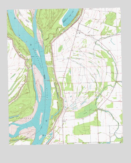
Avon, MS USGS Topographic Map
Click on map above to begin viewing in our Map Viewer.

This topographic map contains these locations and features:
Feature Name Type Latitude Longitude GNIS ID View Map
Alexander Memorial Baptist ChurchChurchN33.2023°W91.0546°687152View Map
American Cutoff RevetmentLeveeN33.2454°W91.0929°61772View Map
Auburn LandingLocaleN33.2085°W91.0809°709275View Map
AvonPopulated PlaceN33.2301°W91.0473°666436View Map
Avon Elementary SchoolSchoolN33.2240°W91.0493°711547View Map
Avon Post OfficePost OfficeN33.2320°W91.0466°2768710View Map
Avon United Methodist ChurchChurchN33.2287°W91.0493°687158View Map
Cornfield ChuteLakeN33.1516°W91.1184°70323View Map
Ditch Number ElevenCanalN33.2023°W91.0340°669277View Map
Ditch Number FourteenCanalN33.1262°W91.0526°669278View Map
Ditch Number Nine ACanalN33.2407°W91.0304°669288View Map
Ditch Number Nine BCanalN33.2332°W91.0087°669289View Map
Ditch Number TenCanalN33.2323°W91.0343°669276View Map
Eggs PointCapeN33.2168°W91.0798°687186View Map
Eggs Point LandingLocaleN33.2168°W91.0798°709278View Map
Glenora LandingLocaleN33.1982°W91.0821°709280View Map
Goose LakeLakeN33.1628°W91.0434°670521View Map
Granny Baker BayouGutN33.1704°W91.0243°670587View Map
Graymound CemeteryCemeteryN33.2246°W91.0326°670635View Map
Island Number 86AreaN33.1682°W91.1071°61768View Map
JamesPopulated PlaceN33.2037°W91.0573°671799View Map
Kentucky BendBendN33.1390°W91.0904°61767View Map
Kentucky Bend BarBarN33.1273°W91.1209°672108View Map
Lake Washington (historical)Populated PlaceN33.1862°W91.0715°687239View Map
Lakeport LandingLocaleN33.2035°W91.0987°61770View Map
Lakeport TowheadIslandN33.2460°W91.1054°61771View Map
Little Sister ChurchChurchN33.2251°W91.0357°672688View Map
LongwoodPopulated PlaceN33.1471°W91.0662°692019View Map
Longwood ChuteGutN33.1635°W91.0687°672862View Map
Longwood LandingLocaleN33.1479°W91.0807°687246View Map
Mississippi Power and Light Company Lake DamDamN33.1618°W91.0718°681895View Map
Riverside Attendance Center (historical)SchoolN33.2271°W91.0457°709291View Map
Saint James ChurchChurchN33.2118°W91.0532°687302View Map
Seven Oaks LandingLocaleN33.1985°W91.0987°61769View Map
Silver LakeLakeN33.1553°W91.0201°677800View Map
Silver Lake (historical)Populated PlaceN33.1979°W91.0612°709292View Map
Silver Lake ChurchChurchN33.1560°W91.0276°677801View Map
Steele Farms AirportAirportN33.1465°W91.0603°2717364View Map
Stella LandingLocaleN33.1326°W91.0846°687327View Map
Supervisor District 1CivilN33.1334°W91.0506°712125View Map
Whiskey ChuteSwampN33.1555°W91.0388°679561View Map

Note: Coordinates in the location and feature list above are referenced to NAD83 datum.


Copyright (C) 2008-2024 Ryan Niemi / Sunset Dynamics ... All Rights Reserved