TopoQuest Logo
Do you find TopoQuest useful?
Help keep TopoQuest running and adding new maps/features by donating!
Bitcoin:  19c7KJd3qBynnjoSw5npx9KScwjBe4ifkT
Litecoin:  LXs6TkuXGGXo1vDsWCkWVdjQX94eUKd6ui
Home View Maps Find Maps Find Places Resources & Links


Gonzales Wash, Arizona Topographic Map

USGS Map Title: Gonzales Wash, AZ
USGS Map MRC: 34113H4
DRG (GeoTIFF) Download: o34113h4.tif


Neighboring USGS Topographic Map Quads:


  Austin Peak, AZ  
35113A5
 

  Penitentiary Mountain, AZ  
35113A4
 

  Devils Hump, AZ  
35113A3
 

  Tom Brown Canyon, AZ  
34113H5
 

  Gonzales Wash, AZ  
34113H4
 

  Mohon Peak, AZ  
34113H3
 

  Tule Wash, AZ  
34113G5
 

  Cedar Basin, AZ  
34113G4
 

  Pilot Knob, AZ  
34113G3


Map MRC Location:

N35°
W114°
N35°
W113°
H8 H7 H6 H5 H4 H3 H2 H1
G8 G7 G6 G5 G4 G3 G2 G1
F8 F7 F6 F5 F4 F3 F2 F1
E8 E7 E6 E5 E4 E3 E2 E1
D8 D7 D6 D5 D4 D3 D2 D1
C8 C7 C6 C5 C4 C3 C2 C1
B8 B7 B6 B5 B4 B3 B2 B1
A8 A7 A6 A5 A4 A3 A2 A1
N34°
W114°
N34°
W113°

Gonzales Wash, AZ USGS 1:24K Topographic Map Preview:
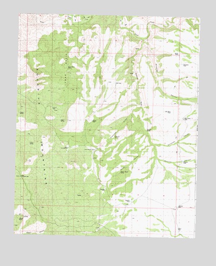
Gonzales Wash, AZ USGS Topographic Map
Click on map above to begin viewing in our Map Viewer.

This topographic map contains these locations and features:
Feature Name Type Latitude Longitude GNIS ID View Map
Antelope TankReservoirN34.8926°W113.3875°22809View Map
Black Butte TankReservoirN34.9428°W113.3849°22829View Map
Cabezas SpringSpringN34.8836°W113.4966°22856View Map
Coters TankReservoirN34.8801°W113.3872°22891View Map
Coyote SpringSpringN34.9436°W113.4980°22897View Map
Dividing CanyonValleyN34.9842°W113.4149°22913View Map
Eds TankReservoirN34.9620°W113.4327°22927View Map
Gonzales CanyonValleyN34.9289°W113.4072°22955View Map
Gonzales SpringSpringN34.9350°W113.4099°22956View Map
Gonzales WashStreamN34.9875°W113.4158°5150View Map
Hidden TankReservoirN34.9400°W113.4480°22986View Map
Horseshoe TankReservoirN34.9736°W113.3860°23001View Map
Indian SpringSpringN34.9264°W113.4908°23008View Map
Island TankReservoirN34.9786°W113.3894°23010View Map
Little MesaSummitN34.9428°W113.3849°7144View Map
Little Mesa TankReservoirN34.9461°W113.3938°23062View Map
Lower BasinBasinN34.9675°W113.4685°23067View Map
Lower Basin SpringSpringN34.9703°W113.4660°7448View Map
Lower Simmons PeakSummitN34.9181°W113.4413°7507View Map
Lower Simmons WellWellN34.9239°W113.4455°23069View Map
Parsons FieldAirportN34.9991°W113.4618°45381View Map
Pipeline TankReservoirN34.8951°W113.4201°23146View Map
Red CanyonValleyN34.8892°W113.4966°23157View Map
Simmons GulchValleyN34.9489°W113.4147°11349View Map
Simmons SpringSpringN34.9311°W113.4324°23210View Map
Skunk CanyonValleyN34.9278°W113.4072°11408View Map
Skunk Canyon SpringSpringN34.9117°W113.4277°23213View Map
Upper Hidden Simmons GonzalesSummitN34.9397°W113.4644°13091View Map
Upper Simmons WellWellN34.9247°W113.4644°23269View Map
Upper SpringSpringN34.9400°W113.4697°23270View Map
Upper Tom Brown WellWellN34.9075°W113.4966°23271View Map
Wagon Bow RanchLocaleN34.9020°W113.4377°23276View Map
Wagon CanyonValleyN34.8753°W113.4944°13268View Map
Wagon Canyon SpringSpringN34.8756°W113.4838°23277View Map
Winslow CanyonValleyN34.9272°W113.4047°23304View Map
Winslow TankReservoirN34.9186°W113.3847°23305View Map

Note: Coordinates in the location and feature list above are referenced to NAD83 datum.


Copyright (C) 2008-2025 Ryan Niemi / Sunset Dynamics ... All Rights Reserved