TopoQuest Logo
Do you find TopoQuest useful?
Help keep TopoQuest running and adding new maps/features by donating!
Bitcoin:  19c7KJd3qBynnjoSw5npx9KScwjBe4ifkT
Litecoin:  LXs6TkuXGGXo1vDsWCkWVdjQX94eUKd6ui
Home View Maps Find Maps Find Places Resources & Links


Goodfield, Tennessee Topographic Map

USGS Map Title: Goodfield, TN
USGS Map MRC: 35084D7
DRG (GeoTIFF) Download: o35084d7.tif


Neighboring USGS Topographic Map Quads:


  Evensville, TN  
35084E8
 

  Decatur, TN  
35084E7
 

  Tranquillity, TN  
35084E6
 

  Big Spring, TN  
35084D8
 

  Goodfield, TN  
35084D7
 

  Riceville, TN  
35084D6
 

  Birchwood, TN  
35084C8
 

  Charleston, TN  
35084C7
 

  Calhoun, TN  
35084C6


Map MRC Location:

N36°
W85°
N36°
W84°
H8 H7 H6 H5 H4 H3 H2 H1
G8 G7 G6 G5 G4 G3 G2 G1
F8 F7 F6 F5 F4 F3 F2 F1
E8 E7 E6 E5 E4 E3 E2 E1
D8 D7 D6 D5 D4 D3 D2 D1
C8 C7 C6 C5 C4 C3 C2 C1
B8 B7 B6 B5 B4 B3 B2 B1
A8 A7 A6 A5 A4 A3 A2 A1
N35°
W85°
N35°
W84°

Goodfield, TN USGS 1:24K Topographic Map Preview:
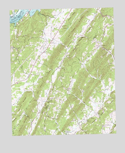
Goodfield, TN USGS Topographic Map
Click on map above to begin viewing in our Map Viewer.

This topographic map contains these locations and features:
Feature Name Type Latitude Longitude GNIS ID View Map
Able RidgeRidgeN35.4678°W84.7897°1275429View Map
AllenPopulated PlaceN35.4351°W84.8522°1647231View Map
Allen BranchStreamN35.4270°W84.8566°1275575View Map
BetaPopulated PlaceN35.4265°W84.8708°1647233View Map
Bethsadia CemeteryCemeteryN35.4681°W84.8266°1320102View Map
Bethsadia ChurchChurchN35.4684°W84.8263°1305183View Map
Big Spring Post OfficePost OfficeN35.4295°W84.8594°1650134View Map
Blevin Mill (historical)LocaleN35.4976°W84.8388°1309879View Map
Breeden PondReservoirN35.4800°W84.8056°1278274View Map
Brush CreekStreamN35.4142°W84.7577°1278671View Map
Brush Creek School (historical)SchoolN35.4478°W84.7913°1647798View Map
Buckhorn School (historical)SchoolN35.3845°W84.8188°1316100View Map
Cedar Valley Elementary SchoolSchoolN35.4273°W84.8669°1648265View Map
Clear SpringsPopulated PlaceN35.4623°W84.7649°1314854View Map
Clear Springs Baptist Church CemeteryCemeteryN35.4581°W84.7583°1956196View Map
Clear Springs ChurchChurchN35.4587°W84.7591°1305962View Map
Coffman CemeteryCemeteryN35.4153°W84.8041°1280871View Map
Coffmans Store (historical)LocaleN35.4528°W84.8097°1316103View Map
Coldwater BranchStreamN35.4717°W84.8316°1280910View Map
Coleman SubdivisionPopulated PlaceN35.4848°W84.8708°1309893View Map
Cotton Port RidgeRidgeN35.4623°W84.8602°1281365View Map
Cox CemeteryCemeteryN35.4617°W84.8336°1281483View Map
Decatur CreekStreamN35.4926°W84.8311°1306312View Map
Elder HollowValleyN35.4368°W84.8586°1283602View Map
Folger (historical)Populated PlaceN35.3834°W84.7936°1307523View Map
Goforth SpringSpringN35.4082°W84.8293°1285574View Map
GoodfieldPopulated PlaceN35.4665°W84.8258°1315132View Map
Goodfield CemeteryCemeteryN35.4778°W84.8261°1309911View Map
Goodfield ChurchChurchN35.4795°W84.8241°1285635View Map
Goodfield CreekStreamN35.4998°W84.8547°1285636View Map
Goodfield School (historical)SchoolN35.4790°W84.8258°1643455View Map
Goodfield ShoalsBarN35.4995°W84.8583°1309912View Map
Goodfield ValleyValleyN35.4485°W84.8416°1269596View Map
Hale HollowValleyN35.3965°W84.8602°1647238View Map
Hale Hollow CreekStreamN35.3820°W84.8502°1286521View Map
Hardin CreekStreamN35.4915°W84.8269°1286829View Map
Harmon HollowValleyN35.4616°W84.8011°1647239View Map
Hawk SpringSpringN35.4112°W84.8305°1287169View Map
Hill CemeteryCemeteryN35.4009°W84.7677°1287782View Map
Hill SpringSpringN35.3911°W84.7797°1287805View Map
HillsviewPopulated PlaceN35.3887°W84.8013°1315237View Map
Hillsview School (historical)SchoolN35.3862°W84.7961°1642269View Map
Howser CemeteryCemeteryN35.4456°W84.8355°1288572View Map
Hyde CemeteryCemeteryN35.4226°W84.7599°1288882View Map
Kyle SubdivisionPopulated PlaceN35.4909°W84.8583°1309921View Map
Malones Store (historical)LocaleN35.4495°W84.8433°1316111View Map
Marler SpringSpringN35.4776°W84.8352°1292704View Map
Mayberry BranchStreamN35.4903°W84.8744°1293001View Map
McCorkle SpringSpringN35.4621°W84.7665°1293194View Map
McKenzie CemeteryCemeteryN35.4062°W84.8677°1293360View Map
McMinn County District 8 Hillsview Rural Fire DepartmentBuildingN35.3867°W84.7960°2654846View Map
McMinn RidgeRidgeN35.4767°W84.7797°1269792View Map
Meigs County Emergency Services Fire Rescue Station 2BuildingN35.4265°W84.8697°2654878View Map
Meigs County Emergency Services Fire Rescue Station 3BuildingN35.4862°W84.8105°2654486View Map
Melton CemeteryCemeteryN35.4006°W84.8169°1293565View Map
Middle RidgeRidgeN35.3867°W84.8608°1293690View Map
Minnett CemeteryCemeteryN35.4167°W84.7697°1294055View Map
Mount Harmony ChurchChurchN35.3829°W84.7658°1294620View Map
Perkinson SpringSpringN35.4415°W84.8172°1297196View Map
Perry CemeteryCemeteryN35.4490°W84.8127°1297203View Map
Pierce PondLakeN35.4337°W84.8122°1297429View Map
Plank CemeteryCemeteryN35.3962°W84.7724°1297774View Map
Plank SpringSpringN35.3779°W84.7866°1297775View Map
Pleasant Hill BranchStreamN35.4598°W84.8055°1297848View Map
Pleasant Hill CemeteryCemeteryN35.4528°W84.8072°1320110View Map
Pleasant Hill ChurchChurchN35.4528°W84.8069°1297864View Map
Pleasant Hill School (historical)SchoolN35.4567°W84.8083°1309935View Map
Rockholt SpringSpringN35.4715°W84.7867°1299812View Map
Sewell CemeteryCemeteryN35.3970°W84.8355°1301123View Map
Shiloh CemeteryCemeteryN35.4215°W84.8588°1270077View Map
Shiloh ChurchChurchN35.4212°W84.8499°1303578View Map
Shiloh RidgeRidgeN35.4070°W84.8619°1270095View Map
Shiloh School (historical)SchoolN35.4201°W84.8488°1309941View Map
Short CreekStreamN35.3940°W84.7830°1270186View Map
Short Creek CemeteryCemeteryN35.4195°W84.8069°1956209View Map
Short Creek ChurchChurchN35.4206°W84.8052°1303607View Map
Short Creek SpringSpringN35.4201°W84.8047°1303608View Map
Union GrovePopulated PlaceN35.4984°W84.7680°1647243View Map
Union Grove ChurchChurchN35.4978°W84.7655°1304240View Map
Union Grove School (historical)SchoolN35.4967°W84.7661°1643490View Map
Ward CemeteryCemeteryN35.4478°W84.7811°1273779View Map

Note: Coordinates in the location and feature list above are referenced to NAD83 datum.


Copyright (C) 2008-2024 Ryan Niemi / Sunset Dynamics ... All Rights Reserved