TopoQuest Logo
Do you find TopoQuest useful?
Help keep TopoQuest running and adding new maps/features by donating!
Bitcoin:  19c7KJd3qBynnjoSw5npx9KScwjBe4ifkT
Litecoin:  LXs6TkuXGGXo1vDsWCkWVdjQX94eUKd6ui
Home View Maps Find Maps Find Places Resources & Links


Goshen, West Virginia Topographic Map

USGS Map Title: Goshen, WV
USGS Map MRC: 38080F3
DRG (GeoTIFF) Download: o38080f3.tif


Neighboring USGS Topographic Map Quads:


  Walkersville, WV  
38080G4
 

  Rock Cave, WV  
38080G3
 

  Alton, WV  
38080G2
 

  Hacker Valley, WV  
38080F4
 

  Goshen, WV  
38080F3
 

  Pickens, WV  
38080F2
 

  Diana, WV  
38080E4
 

  Skelt, WV  
38080E3
 

  Samp, WV  
38080E2


Map MRC Location:

N39°
W81°
N39°
W80°
H8 H7 H6 H5 H4 H3 H2 H1
G8 G7 G6 G5 G4 G3 G2 G1
F8 F7 F6 F5 F4 F3 F2 F1
E8 E7 E6 E5 E4 E3 E2 E1
D8 D7 D6 D5 D4 D3 D2 D1
C8 C7 C6 C5 C4 C3 C2 C1
B8 B7 B6 B5 B4 B3 B2 B1
A8 A7 A6 A5 A4 A3 A2 A1
N38°
W81°
N38°
W80°

Goshen, WV USGS 1:24K Topographic Map Preview:
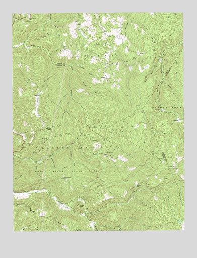
Goshen, WV USGS Topographic Map
Click on map above to begin viewing in our Map Viewer.

This topographic map contains these locations and features:
Feature Name Type Latitude Longitude GNIS ID View Map
ArvondalePopulated PlaceN38.6945°W80.2665°1553755View Map
Bee RunStreamN38.6268°W80.2981°1535506View Map
Bens FlatsFlatN38.7379°W80.2567°1535642View Map
Big Lick RunStreamN38.6440°W80.2873°1535885View Map
Big RunStreamN38.6670°W80.3634°1535910View Map
Big RunStreamN38.6296°W80.3156°1535941View Map
Big Run GapGapN38.6832°W80.3490°1535960View Map
Birchpen RunStreamN38.6757°W80.3292°1536032View Map
CanaanPopulated PlaceN38.7445°W80.2956°1554058View Map
Cleveland MountainSummitN38.7440°W80.3617°1554148View Map
Conrad ForkStreamN38.7045°W80.3323°1537586View Map
CraddockPopulated PlaceN38.7226°W80.2662°1554212View Map
Crooked ForkStreamN38.6732°W80.3345°1537836View Map
Devil ForkStreamN38.6940°W80.2651°1538152View Map
EdenPopulated PlaceN38.7437°W80.3279°1554364View Map
Edward T Balli SpringSpringN38.6551°W80.2517°1677664View Map
Fall RunStreamN38.6343°W80.3220°1538850View Map
Fall RunStreamN38.7412°W80.3542°1538845View Map
GoshenPopulated PlaceN38.7123°W80.3065°1539540View Map
Goshen ChurchChurchN38.7123°W80.3065°1696699View Map
Gregory CemeteryCemeteryN38.7301°W80.3370°1539734View Map
Haystack KnobSummitN38.7362°W80.3551°1554666View Map
Hell RunStreamN38.7245°W80.2656°1540130View Map
High Rock TrailTrailN38.6720°W80.3537°1540252View Map
Holly River State ParkParkN38.6648°W80.3345°1540398View Map
Howell ForkStreamN38.7168°W80.3306°1540530View Map
Johns RunStreamN38.6415°W80.3420°1540965View Map
Left Fork Laurel ForkStreamN38.6687°W80.3140°1541676View Map
Left Fork Right Fork Little Kanawha RiverStreamN38.7329°W80.3670°1541710View Map
Life CemeteryCemeteryN38.7120°W80.3615°1541954View Map
Long RunStreamN38.7204°W80.3448°1542399View Map
Long Run ChurchChurchN38.7029°W80.3559°1542423View Map
Mader RunStreamN38.6507°W80.2626°1542677View Map
Mayton (historical)Populated PlaceN38.6898°W80.2892°1727876View Map
Middle Fork Laurel ForkStreamN38.6698°W80.3123°1543184View Map
New Mayton School (historical)SchoolN38.6659°W80.2956°1727887View Map
Old CemeteryCemeteryN38.6465°W80.3370°1544349View Map
Painter RunStreamN38.7112°W80.2648°1544526View Map
Penbro (historical)Populated PlaceN38.6518°W80.2842°1727893View Map
Pleasant Hill ChurchChurchN38.6607°W80.2579°1544996View Map
Potato KnobSummitN38.6390°W80.3270°1555399View Map
Reverie TrailTrailN38.6790°W80.3473°1545513View Map
Rice CemeteryCemeteryN38.7382°W80.3086°1545530View Map
Right Fork Laurel ForkStreamN38.6687°W80.3140°1545658View Map
Rockcamp RunStreamN38.7037°W80.3326°1545944View Map
Salt Lick TrailTrailN38.6657°W80.3517°1546305View Map
Slab Camp RunStreamN38.7451°W80.3473°1546882View Map
Snake RunStreamN38.7295°W80.2581°1547024View Map
Spruce ForkStreamN38.7101°W80.3515°1547234View Map
Spruce RunStreamN38.7270°W80.3473°1547270View Map
SuncrestPopulated PlaceN38.6882°W80.2534°1555751View Map
Tater Knob RunStreamN38.6390°W80.3342°1727919View Map
Tecumseh FallsFallsN38.6775°W80.3497°1547952View Map
Tenskwatawa FallsFallsN38.6551°W80.3382°1547980View Map
Tramontane TrailTrailN38.6587°W80.3504°1548251View Map
Turkey ForkStreamN38.7198°W80.3331°1548342View Map
Vance CemeteryCemeteryN38.6470°W80.3470°1548619View Map
Vance School (historical)SchoolN38.6390°W80.3373°1727924View Map
Wilderness TrailTrailN38.6643°W80.3287°1549141View Map
Windy GapGapN38.6512°W80.2848°1549243View Map
Windy Gap School (historical)SchoolN38.6507°W80.2854°1727937View Map
Winterfield HollowValleyN38.6498°W80.2523°1549252View Map

Note: Coordinates in the location and feature list above are referenced to NAD83 datum.


Copyright (C) 2008-2025 Ryan Niemi / Sunset Dynamics ... All Rights Reserved