TopoQuest Logo
Do you find TopoQuest useful?
Help keep TopoQuest running and adding new maps/features by donating!
Bitcoin:  19c7KJd3qBynnjoSw5npx9KScwjBe4ifkT
Litecoin:  LXs6TkuXGGXo1vDsWCkWVdjQX94eUKd6ui
Home View Maps Find Maps Find Places Resources & Links


Rock Cave, West Virginia Topographic Map

USGS Map Title: Rock Cave, WV
USGS Map MRC: 38080G3
DRG (GeoTIFF) Download: o38080g3.tif


Neighboring USGS Topographic Map Quads:


  Roanoke, WV  
38080H4
 

  Adrian, WV  
38080H3
 

  Buckhannon, WV  
38080H2
 

  Walkersville, WV  
38080G4
 

  Rock Cave, WV  
38080G3
 

  Alton, WV  
38080G2
 

  Hacker Valley, WV  
38080F4
 

  Goshen, WV  
38080F3
 

  Pickens, WV  
38080F2


Map MRC Location:

N39°
W81°
N39°
W80°
H8 H7 H6 H5 H4 H3 H2 H1
G8 G7 G6 G5 G4 G3 G2 G1
F8 F7 F6 F5 F4 F3 F2 F1
E8 E7 E6 E5 E4 E3 E2 E1
D8 D7 D6 D5 D4 D3 D2 D1
C8 C7 C6 C5 C4 C3 C2 C1
B8 B7 B6 B5 B4 B3 B2 B1
A8 A7 A6 A5 A4 A3 A2 A1
N38°
W81°
N38°
W80°

Rock Cave, WV USGS 1:24K Topographic Map Preview:
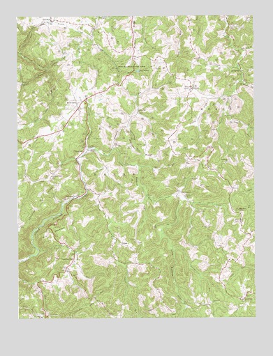
Rock Cave, WV USGS Topographic Map
Click on map above to begin viewing in our Map Viewer.

This topographic map contains these locations and features:
Feature Name Type Latitude Longitude GNIS ID View Map
ArlingtonPopulated PlaceN38.8001°W80.3431°1535006View Map
Banks District (historical)CivilN38.7812°W80.3212°1928163View Map
Banks District Volunteer Fire DepartmentBuildingN38.8382°W80.3420°2577957View Map
Bethlehem ChurchChurchN38.8143°W80.2648°1535730View Map
Big Run KnobSummitN38.7945°W80.2584°1535961View Map
Bob PeakSummitN38.8384°W80.3270°1696647View Map
Buttonwood RunStreamN38.8295°W80.3170°1536808View Map
CarterPopulated PlaceN38.8445°W80.2823°1537067View Map
Center ChapelChurchN38.8451°W80.2823°1537152View Map
Cow RunStreamN38.8157°W80.3440°1537744View Map
Crooked RunStreamN38.8534°W80.3593°1537847View Map
Cub RunStreamN38.8001°W80.3073°1537899View Map
EvergreenPopulated PlaceN38.8543°W80.2581°1538764View Map
Fall RunStreamN38.8593°W80.3734°1538851View Map
Flatwoods RunStreamN38.8195°W80.3381°1539073View Map
French Creek Game FarmParkN38.8545°W80.3137°1539260View Map
FrenchtonPopulated PlaceN38.8729°W80.3565°1539263View Map
GainesPopulated PlaceN38.7804°W80.3201°1554522View Map
Getout RunStreamN38.7793°W80.2937°1539378View Map
Grassy CreekStreamN38.8420°W80.2665°1539627View Map
Heaston RidgeRidgeN38.7920°W80.3693°1540105View Map
Heaston School (historical)SchoolN38.7940°W80.3690°1696702View Map
Holly GrovePopulated PlaceN38.8020°W80.2895°1549748View Map
Joes RunStreamN38.8129°W80.3115°1540936View Map
Kanawha Chapel ChurchChurchN38.8084°W80.3568°1541062View Map
Kanawha HeadPopulated PlaceN38.7729°W80.3465°1554843View Map
Kanawha Head Post OfficePost OfficeN38.7709°W80.3497°1696715View Map
Kanawha RunStreamN38.8207°W80.3237°1541068View Map
Kanawha Run ChurchChurchN38.8348°W80.3112°1541070View Map
Kanawha Run School (historical)SchoolN38.8454°W80.3034°1696716View Map
Knabenshue School (historical)SchoolN38.7534°W80.2665°1696721View Map
Laurel Park ChurchChurchN38.8729°W80.2537°1541487View Map
Laurel RunStreamN38.8737°W80.3231°1541506View Map
Laurel RunStreamN38.8029°W80.3381°1541536View Map
Left Fork French CreekStreamN38.8668°W80.3373°1541658View Map
Lower Laurel Fork School (historical)SchoolN38.8687°W80.2654°1696732View Map
Lynn Camp RunStreamN38.7779°W80.3640°1542633View Map
Magnolia School (historical)SchoolN38.8173°W80.2620°1696733View Map
McDavidson SpringSpringN38.7695°W80.3476°1678170View Map
Meade District (historical)CivilN38.8693°W80.2642°1928310View Map
Mount Zion CemeteryCemeteryN38.7834°W80.2734°1543803View Map
Mount Zion ChurchChurchN38.7873°W80.2754°1543825View Map
Mulberry RidgeRidgeN38.8701°W80.3134°1543982View Map
Mulberry Ridge School (historical)SchoolN38.8684°W80.3140°1696742View Map
Oak Grove ChurchChurchN38.7709°W80.3495°1544285View Map
Oak Grove School (historical)SchoolN38.7737°W80.3456°1696749View Map
Pleasant Dale CemeteryCemeteryN38.7580°W80.2577°2586152View Map
Pleasant Dale ChurchChurchN38.7576°W80.2562°1544980View Map
Pleasant RidgeRidgeN38.8179°W80.3131°1545011View Map
Pleasant Ridge School (historical)SchoolN38.8176°W80.3067°1696756View Map
Prit MountainSummitN38.7862°W80.3517°1555415View Map
Providence ChurchChurchN38.7998°W80.2867°1545298View Map
Queens ForkStreamN38.8476°W80.2570°1545340View Map
Rich RunStreamN38.8609°W80.2565°1545551View Map
Rock CavePopulated PlaceN38.8368°W80.3426°1555498View Map
Rock Cave CemeteryCemeteryN38.8368°W80.3492°1696764View Map
Rock Cave Elementary SchoolSchoolN38.8440°W80.3322°1696765View Map
Rock Cave Post OfficePost OfficeN38.8369°W80.3430°1696766View Map
Salem ChurchChurchN38.7820°W80.3131°1546288View Map
Salem School (historical)SchoolN38.7823°W80.3131°1696770View Map
Sand RunStreamN38.8637°W80.3362°1546372View Map
Seng RunStreamN38.8354°W80.2654°1546573View Map
Shinar School (historical)SchoolN38.7648°W80.3584°1696777View Map
Straight ForkStreamN38.8523°W80.3590°1547564View Map
The FishpondReservoirN38.8522°W80.3113°1548003View Map
Third DistrictCivilN38.8379°W80.3014°1928380View Map
Waterloo ChurchChurchN38.8568°W80.2784°1548831View Map
West Virginia Division of Forestry Upshur County Field OfficeBuildingN38.8574°W80.3129°2577806View Map
Whites Camp ForkStreamN38.8523°W80.3587°1549092View Map
Wilson ChapelChurchN38.8195°W80.3365°1549217View Map
WilsontownPopulated PlaceN38.8212°W80.3387°1549994View Map
ZionPopulated PlaceN38.7734°W80.2645°1696811View Map
Zion School (historical)SchoolN38.7765°W80.2656°1696812View Map

Note: Coordinates in the location and feature list above are referenced to NAD83 datum.


Copyright (C) 2008-2025 Ryan Niemi / Sunset Dynamics ... All Rights Reserved