TopoQuest Logo
Do you find TopoQuest useful?
Help keep TopoQuest running and adding new maps/features by donating!
Bitcoin:  19c7KJd3qBynnjoSw5npx9KScwjBe4ifkT
Litecoin:  LXs6TkuXGGXo1vDsWCkWVdjQX94eUKd6ui
Home View Maps Find Maps Find Places Resources & Links


Grandfather Mountain, North Carolina Topographic Map

USGS Map Title: Grandfather Mountain, NC
USGS Map MRC: 36081A7
DRG (GeoTIFF) Download: o36081a7.tif


Neighboring USGS Topographic Map Quads:


  Elk Park, NC  
36081B8
 

  Valle Crucis, NC  
36081B7
 

  Boone, NC  
36081B6
 

  Newland, NC  
36081A8
 

  Grandfather Mountain, NC  
36081A7
 

  Globe, NC  
36081A6
 

  Linville Falls, NC  
35081H8
 

  Chestnut Mountain, NC  
35081H7
 

  Collettsville, NC  
35081H6


Map MRC Location:

N37°
W82°
N37°
W81°
H8 H7 H6 H5 H4 H3 H2 H1
G8 G7 G6 G5 G4 G3 G2 G1
F8 F7 F6 F5 F4 F3 F2 F1
E8 E7 E6 E5 E4 E3 E2 E1
D8 D7 D6 D5 D4 D3 D2 D1
C8 C7 C6 C5 C4 C3 C2 C1
B8 B7 B6 B5 B4 B3 B2 B1
A8 A7 A6 A5 A4 A3 A2 A1
N36°
W82°
N36°
W81°

Grandfather Mountain, NC USGS 1:24K Topographic Map Preview:
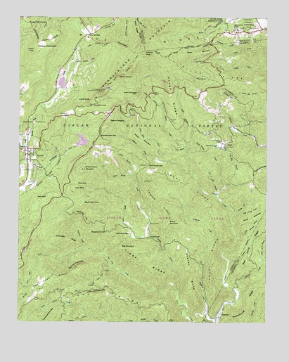
Grandfather Mountain, NC USGS Topographic Map
Click on map above to begin viewing in our Map Viewer.

This topographic map contains these locations and features:
Feature Name Type Latitude Longitude GNIS ID View Map
Andrews CreekStreamN36.0660°W81.7984°1008731View Map
Appalachian CampLocaleN36.1204°W81.7659°1008756View Map
Bark Camp RidgeRidgeN36.0318°W81.7573°1008920View Map
Beacon HeightsSummitN36.0824°W81.8301°1018993View Map
Bee BranchStreamN36.0693°W81.7898°1009104View Map
Bee MountainSummitN36.0307°W81.8232°1019048View Map
Big Grassy CreekStreamN36.1048°W81.8501°1009323View Map
Big Lost Cove CliffsCliffN36.0235°W81.8454°1009337View Map
Big Lost Cove RidgeRidgeN36.0162°W81.8573°1009338View Map
Big Rough KnobSummitN36.0487°W81.8423°1019161View Map
Breakneck RidgeRidgeN36.0340°W81.8493°1009583View Map
Brier KnobSummitN36.0812°W81.8734°1019296View Map
Bucks Timber CreekStreamN36.0518°W81.7740°1009788View Map
Calloway PeakSummitN36.1112°W81.8115°1019477View Map
Cary Flat BranchStreamN36.0560°W81.7707°1010079View Map
Cary Flat CemeteryCemeteryN36.0723°W81.7718°1010080View Map
Cherokee WoodsPopulated PlaceN36.1076°W81.7621°1017898View Map
Chestnut Cove BranchStreamN36.0029°W81.8393°1010234View Map
Coffey Trout LakeReservoirN36.0721°W81.7732°1010365View Map
Crusher BranchStreamN36.0254°W81.7684°1010600View Map
Daniel Boone Scout TrailTrailN36.1093°W81.8023°1010645View Map
Deep GapGapN36.0571°W81.8459°1010752View Map
EdgemontPopulated PlaceN36.0024°W81.7748°1020109View Map
Edgemont Baptist ChurchChurchN36.0021°W81.7729°1017891View Map
Flat Land BranchStreamN36.0526°W81.7740°1011261View Map
Flat RockSummitN36.0510°W81.8609°1020275View Map
Flattop CliffsCliffN36.1115°W81.8676°1011271View Map
Flattop MountainSummitN36.1151°W81.8618°1020283View Map
Gabes MountainRidgeN36.0765°W81.8182°1020385View Map
GraggPopulated PlaceN36.0732°W81.7707°1020484View Map
Gragg CemeteryCemeteryN36.0846°W81.7701°1011584View Map
Gragg CemeteryCemeteryN36.0643°W81.8143°985907View Map
Gragg ProngStreamN36.0126°W81.7934°1011588View Map
GrandfatherPopulated PlaceN36.0990°W81.8476°1027619View Map
Grandfather MountainRidgeN36.1112°W81.8115°1020486View Map
Grandfather Mountain LakeReservoirN36.0973°W81.8537°1017336View Map
Grandfather Mountain Lake Lake DamDamN36.0935°W81.8632°1017335View Map
Grandmother DamDamN36.0718°W81.8465°1017333View Map
Grandmother GapGapN36.0765°W81.8348°1011600View Map
Grandmother LakeReservoirN36.0745°W81.8431°1017334View Map
Grandmother MountainSummitN36.0626°W81.8426°1020488View Map
Green MountainSummitN36.1107°W81.7832°1020545View Map
Green Mountain CreekStreamN36.1126°W81.7623°1011707View Map
Green RidgeRidgeN36.1210°W81.8173°1011710View Map
Hemlock RidgePopulated PlaceN36.1182°W81.7676°1008222View Map
Hopkins ChapelChurchN36.0407°W81.8093°1012178View Map
Hughes RidgeRidgeN36.0357°W81.7932°1012268View Map
Inver Lochy DamDamN36.1218°W81.8365°1017338View Map
Inver Lochy LakeReservoirN36.1213°W81.8356°1017337View Map
Laurel CreekStreamN36.0121°W81.7632°1012728View Map
Laurel MountainSummitN36.0415°W81.7621°1021113View Map
Laurel Mountain BranchStreamN36.0351°W81.7643°1012748View Map
Ling BranchStreamN36.0604°W81.8159°1012884View Map
Linn Cove BranchStreamN36.0879°W81.8029°1012886View Map
LinvillePopulated PlaceN36.0665°W81.8704°1021158View Map
Linville BluffsCliffN36.0910°W81.8398°1012887View Map
Linville GapGapN36.1176°W81.8418°1012894View Map
Linville Post OfficePost OfficeN36.0713°W81.8712°2774303View Map
Linville Volunteer Fire and RescueBuildingN36.0795°W81.8700°2638178View Map
Little BaldSummitN36.0546°W81.8471°1021164View Map
Little Grassy CreekStreamN36.1087°W81.8468°1012967View Map
Little Laurel CreekStreamN36.0460°W81.7634°1012986View Map
Little Lost Cove CliffsCliffN36.0124°W81.8348°1012988View Map
Little Lost Cove CreekStreamN36.0229°W81.8265°1012989View Map
Little Wilson CreekStreamN36.0712°W81.7893°1013046View Map
Long RidgeRidgeN36.0082°W81.8104°1013170View Map
Lost Cove CreekStreamN36.0015°W81.7743°1013199View Map
Major BranchStreamN36.0604°W81.8190°1013297View Map
Marks MountainSummitN36.0412°W81.7993°1021349View Map
Mile High Swinging BridgeBridgeN36.0948°W81.8326°1013529View Map
Ned MountainSummitN36.0360°W81.8265°1021608View Map
New Hopewell ChurchChurchN36.0746°W81.7729°1013928View Map
North Harper CreekStreamN36.0001°W81.8040°1014013View Map
Old House GapGapN36.0643°W81.8096°1014097View Map
Peoples ChurchChurchN36.0721°W81.8743°1014331View Map
Pilot KnobSummitN36.1004°W81.7862°1021900View Map
Pilot RidgeRidgeN36.0990°W81.7754°1014404View Map
Poplar Spring BranchStreamN36.0265°W81.7507°1014597View Map
Rattlesnake CliffsCliffN36.0443°W81.8432°1022150View Map
Raven RocksSummitN36.1015°W81.8240°1022168View Map
Rockhouse CreekStreamN36.0043°W81.7796°1015009View Map
RoseboroughPopulated PlaceN36.0349°W81.8090°1022395View Map
Rough RidgeRidgeN36.0912°W81.7990°1015105View Map
Sassafras CreekStreamN36.0299°W81.8418°1015267View Map
Sassafras KnobSummitN36.0365°W81.8376°1022509View Map
Schoolhouse RidgeRidgeN36.0071°W81.7587°1015327View Map
Stack Rock CreekStreamN36.0599°W81.7868°1015773View Map
Tanglewood CemeteryCemeteryN36.0812°W81.8671°1016019View Map
The Sphinx RockPillarN36.0893°W81.8379°1016096View Map
Timber RidgeRidgeN36.0232°W81.8115°1016153View Map
Township of Carey's FlatCivilN36.0342°W81.8098°2403053View Map
Township of LinvilleCivilN36.0887°W81.8516°1026402View Map
Turkey BranchStreamN36.0449°W81.7659°1016265View Map
United States Weather StationLocaleN36.0954°W81.8315°1018004View Map
Village of GrandfatherCivilN36.0988°W81.8481°2407469View Map
Webb CreekStreamN36.0354°W81.8084°1016491View Map
West Fork Linville RiverStreamN36.0718°W81.8732°1016537View Map
Wilsons Creek Township (historical)CivilN36.0385°W81.8151°1026405View Map
WUNE-TV (Linville)TowerN36.0632°W81.8423°1018603View Map
Yancey RidgeRidgeN36.0399°W81.7721°1016855View Map
Yancey Ridge TrailTrailN36.0318°W81.7748°1018118View Map

Note: Coordinates in the location and feature list above are referenced to NAD83 datum.


Copyright (C) 2008-2024 Ryan Niemi / Sunset Dynamics ... All Rights Reserved