TopoQuest Logo
Do you find TopoQuest useful?
Help keep TopoQuest running and adding new maps/features by donating!
Bitcoin:  19c7KJd3qBynnjoSw5npx9KScwjBe4ifkT
Litecoin:  LXs6TkuXGGXo1vDsWCkWVdjQX94eUKd6ui
Home View Maps Find Maps Find Places Resources & Links


Granite, Oregon Topographic Map

USGS Map Title: Granite, OR
USGS Map MRC: 44118G4
DRG (GeoTIFF) Download: o44118g4.tif


Neighboring USGS Topographic Map Quads:


  Silver Butte, OR  
44118H5
 

  Trout Meadows, OR  
44118H4
 

  Crawfish Lake, OR  
44118H3
 

  Olive Lake, OR  
44118G5
 

  Granite, OR  
44118G4
 

  Mount Ireland, OR  
44118G3
 

  Vinegar Hill, OR  
44118F5
 

  Greenhorn, OR  
44118F4
 

  Whitney, OR  
44118F3


Map MRC Location:

N45°
W119°
N45°
W118°
H8 H7 H6 H5 H4 H3 H2 H1
G8 G7 G6 G5 G4 G3 G2 G1
F8 F7 F6 F5 F4 F3 F2 F1
E8 E7 E6 E5 E4 E3 E2 E1
D8 D7 D6 D5 D4 D3 D2 D1
C8 C7 C6 C5 C4 C3 C2 C1
B8 B7 B6 B5 B4 B3 B2 B1
A8 A7 A6 A5 A4 A3 A2 A1
N44°
W119°
N44°
W118°

Granite, OR USGS 1:24K Topographic Map Preview:
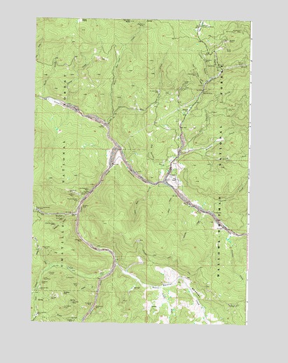
Granite, OR USGS Topographic Map
Click on map above to begin viewing in our Map Viewer.

This topographic map contains these locations and features:
Feature Name Type Latitude Longitude GNIS ID View Map
Ajax MineMineN44.8563°W118.4008°1137040View Map
AlamoLocaleN44.7701°W118.4608°1137044View Map
Alamo GulchValleyN44.7635°W118.4611°1137045View Map
Alamo MineMineN44.7649°W118.4744°1137046View Map
Alamo Post Office (historical)Post OfficeN44.7701°W118.4608°1164814View Map
Beaver CreekStreamN44.7749°W118.4502°1137822View Map
Beaver MeadowsFlatN44.7668°W118.4166°1137840View Map
Big Four MineMineN44.8729°W118.4377°1138030View Map
Big Gordon GulchValleyN44.8129°W118.4219°1138031View Map
Blackjack MineMineN44.7838°W118.4716°1138231View Map
Blue Mountain MineMineN44.7904°W118.4869°1138322View Map
Blue Ribbon MineMineN44.8710°W118.3816°1138326View Map
Bluebird MineMineN44.7663°W118.4944°1158130View Map
Bluebird MineMineN44.7976°W118.4716°1158131View Map
Boston TunnelMineN44.8635°W118.3897°1138452View Map
Boulder CreekStreamN44.8193°W118.4155°1138479View Map
Buck CreekStreamN44.8415°W118.4947°1138765View Map
Buck GulchValleyN44.7510°W118.4699°1138790View Map
Buffalo MineMineN44.8665°W118.3883°1138881View Map
Bull Run CreekStreamN44.8079°W118.4252°1138915View Map
Butcher Boy MineMineN44.7638°W118.4949°1139034View Map
China GulchValleyN44.8488°W118.4024°1139679View Map
Chipman GulchValleyN44.8540°W118.3933°1139701View Map
City of GraniteCivilN44.8100°W118.4187°2410642View Map
Clear CreekStreamN44.8215°W118.4505°1139787View Map
Congo GulchValleyN44.7946°W118.4738°1140035View Map
Corral CreekStreamN44.7960°W118.3966°1140144View Map
Corrigal SpringSpringN44.7579°W118.3801°1152804View Map
Corrigal Spring CampgroundLocaleN44.7582°W118.3799°1140159View Map
Cougar MineMineN44.8488°W118.4138°1140234View Map
Cox TunnelsMineN44.8701°W118.3858°1140302View Map
Crane Flats Forest Service StationLocaleN44.8724°W118.4049°1140379View Map
Dry CreekStreamN44.7504°W118.4999°1141304View Map
East Ten Cent CreekStreamN44.8354°W118.4541°1141647View Map
Fremont PowerhouseBuildingN44.7963°W118.4977°1142455View Map
Golars Goat TrailTrailN44.7774°W118.4274°1142801View Map
GranitePopulated PlaceN44.8093°W118.4177°1142911View Map
Granite City OfficeBuildingN44.8092°W118.4177°2700368View Map
Granite Post Office (historical)Post OfficeN44.8093°W118.4177°1165338View Map
Granite Roadmaster OfficeBuildingN44.8092°W118.4177°2700369View Map
Gray Eagle MineMineN44.7924°W118.4824°1143003View Map
Gutridge CreekStreamN44.7957°W118.3997°1143165View Map
Happy PrairieFlatN44.8740°W118.4747°1143288View Map
Humpback MineMineN44.7560°W118.4813°1143912View Map
Independence MineMineN44.8518°W118.4069°1144013View Map
Jay Bird MineMineN44.8024°W118.4761°1144230View Map
Kúckuc CreekStreamN44.8390°W118.4819°1150238View Map
Lamb CreekStreamN44.8038°W118.4172°1144797View Map
Last Chance CreekStreamN44.8215°W118.4105°1144849View Map
Lawton (historical)LocaleN44.8179°W118.4511°1153713View Map
Lawton Post Office (historical)Post OfficeN44.8179°W118.4511°1165522View Map
Lightning CreekStreamN44.7646°W118.4966°1144999View Map
Lightning Creek PlacersMineN44.7529°W118.4969°1145001View Map
Little Blue MineMineN44.7679°W118.4933°1145104View Map
Lon Krise CabinLocaleN44.7524°W118.4997°1167226View Map
Lost Boy GulchValleyN44.8074°W118.4316°1145496View Map
Lost Buck MineMineN44.8385°W118.3886°1145497View Map
Lucas GulchValleyN44.8504°W118.3991°1145647View Map
Magnolia MineMineN44.8590°W118.4022°1145733View Map
May Queen MineMineN44.8038°W118.4797°1145894View Map
Mineral Wonder MineMineN44.7999°W118.4738°1146317View Map
Mosquito GulchValleyN44.7935°W118.4808°1146497View Map
New York MineMineN44.8454°W118.4027°1146804View Map
North Fork Ruby CreekStreamN44.7799°W118.4963°1146995View Map
Olive CreekStreamN44.7799°W118.4569°1147211View Map
Pasture CreekStreamN44.7879°W118.3849°1147484View Map
Poor Boy MineMineN44.8024°W118.4724°1147886View Map
Porterville (historical)Populated PlaceN44.7957°W118.3952°1147914View Map
Quebec HillSummitN44.7621°W118.4819°1148100View Map
Quebec MineMineN44.7607°W118.4863°1148099View Map
Red Boy MineMineN44.7949°W118.4772°1148275View Map
Red Mountain MineMineN44.8049°W118.4677°1148323View Map
Redboy Post Office (historical)Post OfficeN44.7951°W118.4777°1164628View Map
Ruby CreekStreamN44.7738°W118.4888°1148826View Map
Ruby Creek MinesMineN44.7793°W118.4905°1148827View Map
Sawmill FlatFlatN44.8385°W118.4108°1149093View Map
Scandia TunnelMineN44.7701°W118.4899°1149111View Map
South Fork Beaver CreekStreamN44.7651°W118.4255°1149930View Map
South Fork Boulder CreekStreamN44.8221°W118.4019°1149936View Map
South Fork Ruby CreekStreamN44.7799°W118.4963°1150007View Map
Strasburg MineMineN44.7574°W118.4644°1150472View Map
Tabor DiggingsMineN44.8310°W118.4594°1150831View Map
Ten Cent ButteSummitN44.8740°W118.4452°1150965View Map
Ten Cent CreekStreamN44.8313°W118.4580°1150966View Map
Tencent Placer MineMineN44.8451°W118.4280°1127927View Map
Tillicum MineMineN44.8568°W118.3816°1151227View Map
Van Anda MineMineN44.7582°W118.4761°1151721View Map
West Ten Cent CreekStreamN44.8354°W118.4541°1152144View Map
Yellowstone MineMineN44.7568°W118.4630°1152727View Map

Note: Coordinates in the location and feature list above are referenced to NAD83 datum.


Copyright (C) 2008-2024 Ryan Niemi / Sunset Dynamics ... All Rights Reserved