TopoQuest Logo
Do you find TopoQuest useful?
Help keep TopoQuest running and adding new maps/features by donating!
Bitcoin:  19c7KJd3qBynnjoSw5npx9KScwjBe4ifkT
Litecoin:  LXs6TkuXGGXo1vDsWCkWVdjQX94eUKd6ui
Home View Maps Find Maps Find Places Resources & Links


Mount Ireland, Oregon Topographic Map

USGS Map Title: Mount Ireland, OR
USGS Map MRC: 44118G3
DRG (GeoTIFF) Download: o44118g3.tif


Neighboring USGS Topographic Map Quads:


  Trout Meadows, OR  
44118H4
 

  Crawfish Lake, OR  
44118H3
 

  Anthony Lakes, OR  
44118H2
 

  Granite, OR  
44118G4
 

  Mount Ireland, OR  
44118G3
 

  Bourne, OR  
44118G2
 

  Greenhorn, OR  
44118F4
 

  Whitney, OR  
44118F3
 

  Sumpter, OR  
44118F2


Map MRC Location:

N45°
W119°
N45°
W118°
H8 H7 H6 H5 H4 H3 H2 H1
G8 G7 G6 G5 G4 G3 G2 G1
F8 F7 F6 F5 F4 F3 F2 F1
E8 E7 E6 E5 E4 E3 E2 E1
D8 D7 D6 D5 D4 D3 D2 D1
C8 C7 C6 C5 C4 C3 C2 C1
B8 B7 B6 B5 B4 B3 B2 B1
A8 A7 A6 A5 A4 A3 A2 A1
N44°
W119°
N44°
W118°

Mount Ireland, OR USGS 1:24K Topographic Map Preview:
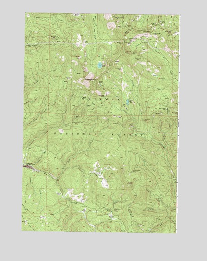
Mount Ireland, OR USGS Topographic Map
Click on map above to begin viewing in our Map Viewer.

This topographic map contains these locations and features:
Feature Name Type Latitude Longitude GNIS ID View Map
Bald Mountain MineMineN44.8110°W118.2877°1117183View Map
Baldy LakeLakeN44.8454°W118.3144°1117200View Map
Beagle CreekStreamN44.7663°W118.3349°1117337View Map
Bear MeadowFlatN44.7579°W118.3586°1117388View Map
Belle of Baker MineMineN44.8207°W118.2608°1117494View Map
Big Dipper SpringSpringN44.8278°W118.3101°1117614View Map
Blue Springs Summit Sno-ParkLocaleN44.7538°W118.2872°1952977View Map
Boundary CreekStreamN44.7871°W118.3747°1117988View Map
Boundary Creek Forest Service StationLocaleN44.7885°W118.3733°1117990View Map
Bubbling SpringSpringN44.8738°W118.3350°1118174View Map
Buck Gulch MineMineN44.7510°W118.2722°1118189View Map
Buckhorn MineMineN44.8582°W118.2969°1118236View Map
Cable CoveBasinN44.8615°W118.2869°1118445View Map
Cableville (historical)Populated PlaceN44.8568°W118.2691°1131067View Map
Cableville Post Office (historical)Post OfficeN44.8568°W118.2691°1164996View Map
California MineMineN44.8643°W118.2772°1118468View Map
Cap Martin MineMineN44.8560°W118.3697°1118590View Map
Channel CreekStreamN44.7851°W118.3411°1118821View Map
Crown PointSummitN44.8526°W118.2936°1119594View Map
Crown Point MineMineN44.8588°W118.2899°1119595View Map
Deep CreekStreamN44.7799°W118.3480°1119788View Map
Downie LakeLakeN44.8252°W118.2915°1120061View Map
East Fork Boundary CreekStreamN44.8107°W118.3430°1120299View Map
Elk Heaven MineMineN44.8676°W118.2977°1120455View Map
Elstow Post Office (historical)Post OfficeN44.8596°W118.3497°1164336View Map
Erin CreekStreamN44.8385°W118.2533°1120515View Map
Erin MeadowFlatN44.8404°W118.2702°1120516View Map
Gold Bug-Grizzly MineMineN44.8113°W118.3322°1121193View Map
Gold CenterLocaleN44.7629°W118.3016°1121194View Map
Gold Center MeadowFlatN44.7596°W118.3030°1121195View Map
Gold Center SpringSpringN44.7629°W118.3036°1121196View Map
Grand Central MineMineN44.8713°W118.2858°1121284View Map
Grand Trunk MineMineN44.8140°W118.2780°1121287View Map
Grays GulchValleyN44.7638°W118.2580°1121354View Map
Grays PeakSummitN44.7782°W118.2894°1121355View Map
Griffith PlacerMineN44.7838°W118.3138°1121434View Map
Haystack MeadowsFlatN44.7629°W118.3238°1121706View Map
Heedie SpringSpringN44.8597°W118.2888°1121731View Map
Herculean MineMineN44.8590°W118.2772°1121765View Map
Ibex MineMineN44.8124°W118.2991°1122180View Map
Imperial Eagle MineMineN44.8640°W118.2719°1116711View Map
Ireland SpringSpringN44.8354°W118.3151°1122263View Map
Ivy May MineMineN44.8693°W118.2708°1122306View Map
Kane CreekStreamN44.7985°W118.2616°1122626View Map
Last Chance MineMineN44.8704°W118.2647°1122968View Map
Lead Lode MineMineN44.8726°W118.2969°1123013View Map
Little Buck CreekStreamN44.7604°W118.2574°1145113View Map
Mahoney MeadowsFlatN44.7713°W118.3444°1123695View Map
Maidens Dream MineMineN44.7851°W118.2866°1123697View Map
Mammoth MineMineN44.8218°W118.2586°1123723View Map
Mile High MineMineN44.8501°W118.2899°1124136View Map
Monumental MineMineN44.8607°W118.3494°1124311View Map
Mormon Boy MineMineN44.8656°W118.2577°1124364View Map
Mount IrelandSummitN44.8365°W118.3208°1124418View Map
O'Farrel GulchValleyN44.7793°W118.2522°1124882View Map
Onion GulchValleyN44.7865°W118.3677°1124998View Map
Ophir MineMineN44.8585°W118.3269°1125012View Map
Oregon Chief MineMineN44.8501°W118.2855°1125022View Map
Red Chief MineMineN44.8607°W118.2688°1125874View Map
Rob Roy MineMineN44.8682°W118.2897°1126103View Map
Sloans RidgeRidgeN44.8735°W118.2669°1149729View Map
Sunnybrook MineMineN44.8429°W118.2969°1127730View Map
Swamp CreekStreamN44.7857°W118.3669°1127791View Map
Umpqua GulchValleyN44.8068°W118.2608°1128406View Map
Uncle Sam MineMineN44.8368°W118.3402°1128408View Map
Weaver PlacerMineN44.7540°W118.2797°1128753View Map
West Fork Boundary CreekStreamN44.8107°W118.3430°1128837View Map

Note: Coordinates in the location and feature list above are referenced to NAD83 datum.


Copyright (C) 2008-2024 Ryan Niemi / Sunset Dynamics ... All Rights Reserved