TopoQuest Logo
Do you find TopoQuest useful?
Help keep TopoQuest running and adding new maps/features by donating!
Bitcoin:  19c7KJd3qBynnjoSw5npx9KScwjBe4ifkT
Litecoin:  LXs6TkuXGGXo1vDsWCkWVdjQX94eUKd6ui
Home View Maps Find Maps Find Places Resources & Links


Granite, Oklahoma Topographic Map

USGS Map Title: Granite, OK
USGS Map MRC: 34099H4
DRG (GeoTIFF) Download: o34099h4.tif


Neighboring USGS Topographic Map Quads:


  Willow, OK  
35099A5
 

  Lake Creek, OK  
35099A4
 

  Retrop SE, OK  
35099A3
 

  Mangum North, OK  
34099H5
 

  Granite, OK  
34099H4
 

  Lake Altus, OK  
34099H3
 

  Mangum South, OK  
34099G5
 

  Hester, OK  
34099G4
 

  Blair, OK  
34099G3


Map MRC Location:

N35°
W100°
N35°
W99°
H8 H7 H6 H5 H4 H3 H2 H1
G8 G7 G6 G5 G4 G3 G2 G1
F8 F7 F6 F5 F4 F3 F2 F1
E8 E7 E6 E5 E4 E3 E2 E1
D8 D7 D6 D5 D4 D3 D2 D1
C8 C7 C6 C5 C4 C3 C2 C1
B8 B7 B6 B5 B4 B3 B2 B1
A8 A7 A6 A5 A4 A3 A2 A1
N34°
W100°
N34°
W99°

Granite, OK USGS 1:24K Topographic Map Preview:
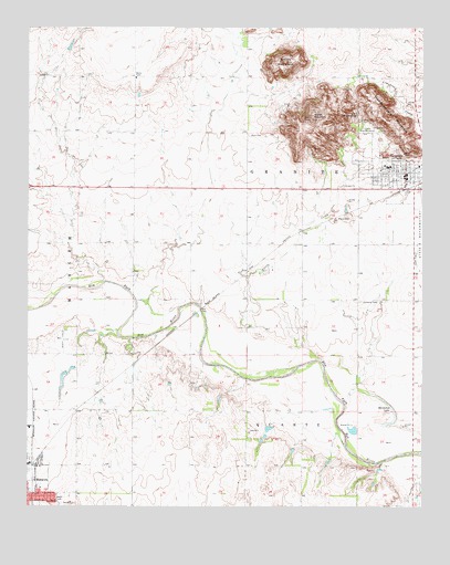
Granite, OK USGS Topographic Map
Click on map above to begin viewing in our Map Viewer.

This topographic map contains these locations and features:
Feature Name Type Latitude Longitude GNIS ID View Map
Brown MountainSummitN34.9912°W99.4187°1090535View Map
Camp Kate PortwoodLocaleN34.9726°W99.3912°1090865View Map
GranitePopulated PlaceN34.9623°W99.3806°1093311View Map
Granite DivisionCivilN34.9950°W99.4120°1937719View Map
Granite Elementary SchoolSchoolN34.9637°W99.3864°1790665View Map
Granite Fire DepartmentBuildingN34.9618°W99.3805°2658332View Map
Granite High SchoolSchoolN34.9637°W99.3859°1790350View Map
Granite Police DepartmentBuildingN34.9602°W99.3812°2757685View Map
Granite Post OfficePost OfficeN34.9615°W99.3818°1814266View Map
Greer County Special Ambulance GraniteBuildingN34.9617°W99.3805°2695896View Map
Headquarters MountainSummitN34.9778°W99.3893°1093633View Map
Horseshoe LakeLakeN34.8966°W99.3868°1093960View Map
Joe Harp Field (historical)AirportN34.9398°W99.3773°1102485View Map
KTIJ-FM (Elk City)TowerN34.9776°W99.4101°1102250View Map
Lutheran CemeteryCemeteryN34.9286°W99.3950°2708446View Map
Rock CemeteryCemeteryN34.9722°W99.4305°1097273View Map
Tittle CreekStreamN34.9117°W99.4140°1098930View Map
Township of GraniteCivilN34.9639°W99.4170°1825376View Map
Walsh MountainSummitN34.9764°W99.4106°1099337View Map

Note: Coordinates in the location and feature list above are referenced to NAD83 datum.


Copyright (C) 2008-2024 Ryan Niemi / Sunset Dynamics ... All Rights Reserved