TopoQuest Logo
Do you find TopoQuest useful?
Help keep TopoQuest running and adding new maps/features by donating!
Bitcoin:  19c7KJd3qBynnjoSw5npx9KScwjBe4ifkT
Litecoin:  LXs6TkuXGGXo1vDsWCkWVdjQX94eUKd6ui
Home View Maps Find Maps Find Places Resources & Links


Grassy Lake, Louisiana Topographic Map

USGS Map Title: Grassy Lake, LA
USGS Map MRC: 29091G1
DRG (GeoTIFF) Download: o29091g1.tif


Neighboring USGS Topographic Map Quads:


  Pierre Part, LA  
29091H2
 

  Napoleonville, LA  
29091H1
 

  Madewood, LA  
29090H8
 

  Napoleonville SW, LA  
29091G2
 

  Grassy Lake, LA  
29091G1
 

  Labadieville, LA  
29090G8
 

  Morgan City, LA  
29091F2
 

  Amelia, LA  
29091F1
 

  Gibson, LA  
29090F8


Map MRC Location:

N30°
W92°
N30°
W91°
H8 H7 H6 H5 H4 H3 H2 H1
G8 G7 G6 G5 G4 G3 G2 G1
F8 F7 F6 F5 F4 F3 F2 F1
E8 E7 E6 E5 E4 E3 E2 E1
D8 D7 D6 D5 D4 D3 D2 D1
C8 C7 C6 C5 C4 C3 C2 C1
B8 B7 B6 B5 B4 B3 B2 B1
A8 A7 A6 A5 A4 A3 A2 A1
N29°
W92°
N29°
W91°

Grassy Lake, LA USGS 1:24K Topographic Map Preview:
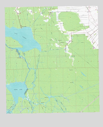
Grassy Lake, LA USGS Topographic Map
Click on map above to begin viewing in our Map Viewer.

This topographic map contains these locations and features:
Feature Name Type Latitude Longitude GNIS ID View Map
Attakapas LandingPopulated PlaceN29.8510°W91.1032°532244View Map
Bay HeronBayN29.8363°W91.0609°532361View Map
Bay MarcaliteBayN29.8319°W91.0504°532373View Map
Bay ShermanBayN29.7685°W91.0679°532385View Map
Bay SylvesterBayN29.8338°W91.0540°532388View Map
Bayou CrabPopulated PlaceN29.8674°W91.0762°532546View Map
Bayou EtienneStreamN29.8530°W91.0643°532587View Map
Bayou FelixStreamN29.7788°W91.0959°559951View Map
Bayou GannevaitStreamN29.8227°W91.1009°553460View Map
Bayou GenevePopulated PlaceN29.8163°W91.1043°559965View Map
Bayou LouisStreamN29.8238°W91.0782°532677View Map
Bayou MagazilleStreamN29.8266°W91.1107°560014View Map
Bayou Morgan CityStreamN29.7522°W91.0487°532699View Map
Bayou ShermanStreamN29.7680°W91.1020°560083View Map
Den BayouGutN29.8094°W91.1004°551515View Map
Dwight FieldsPopulated PlaceN29.8549°W91.0512°543158View Map
First BayLakeN29.8161°W91.0362°554402View Map
Fourmile BayouStreamN29.7858°W91.1004°560790View Map
Grassy LakeLakeN29.7779°W91.1104°560893View Map
Himalaya CanalCanalN29.8321°W91.0270°535677View Map
Hothman BayouStreamN29.7666°W91.0590°535828View Map
Little Texas BayouStreamN29.8235°W91.0790°536619View Map
Lower TexasPopulated PlaceN29.8341°W91.0393°555188View Map
Norman CanalCanalN29.8619°W91.0951°537701View Map
OakleyPopulated PlaceN29.8738°W91.0120°555533View Map
Oakley Gas FieldOilfieldN29.8685°W91.0690°555534View Map
Parish Governing Authority District 4CivilN29.8318°W91.0336°1929997View Map
PerclePopulated PlaceN29.8685°W91.0118°541163View Map
Persimmon PassChannelN29.7583°W91.1165°1627902View Map
Ploton BayouStreamN29.8394°W91.0873°538271View Map
Second BayBayN29.7858°W91.0345°539243View Map
Sherman Bayou Gas FieldOilfieldN29.7577°W91.0473°552914View Map
Simon PassChannelN29.7580°W91.1143°1628233View Map
Upper TexasPopulated PlaceN29.8691°W91.0904°556314View Map
Ward FourCivilN29.8730°W91.0309°544904View Map
Ward ThreeCivilN29.7835°W91.0040°544903View Map
William CanalCanalN29.7694°W91.0507°540420View Map
William CanalCanalN29.8538°W91.0759°540421View Map
Willow LakeLakeN29.7999°W91.0398°556430View Map

Note: Coordinates in the location and feature list above are referenced to NAD83 datum.


Copyright (C) 2008-2024 Ryan Niemi / Sunset Dynamics ... All Rights Reserved