TopoQuest Logo
Do you find TopoQuest useful?
Help keep TopoQuest running and adding new maps/features by donating!
Bitcoin:  19c7KJd3qBynnjoSw5npx9KScwjBe4ifkT
Litecoin:  LXs6TkuXGGXo1vDsWCkWVdjQX94eUKd6ui
Home View Maps Find Maps Find Places Resources & Links


Grassy Lookout, New Mexico Topographic Map

USGS Map Title: Grassy Lookout, NM
USGS Map MRC: 33107G4
DRG (GeoTIFF) Download: o33107g4.tif


Neighboring USGS Topographic Map Quads:


  Monica Saddle, NM  
33107H5
 

  Mount Withington, NM  
33107H4
 

  Squaw Peak, NM  
33107H3
 

  Bay Buck Peaks, NM  
33107G5
 

  Grassy Lookout, NM  
33107G4
 

  Tenmile Hill, NM  
33107G3
 

  Welty Hill, NM  
33107F5
 

  Blue Mountain, NM  
33107F4
 

  San Juan Peak, NM  
33107F3


Map MRC Location:

N34°
W108°
N34°
W107°
H8 H7 H6 H5 H4 H3 H2 H1
G8 G7 G6 G5 G4 G3 G2 G1
F8 F7 F6 F5 F4 F3 F2 F1
E8 E7 E6 E5 E4 E3 E2 E1
D8 D7 D6 D5 D4 D3 D2 D1
C8 C7 C6 C5 C4 C3 C2 C1
B8 B7 B6 B5 B4 B3 B2 B1
A8 A7 A6 A5 A4 A3 A2 A1
N33°
W108°
N33°
W107°

Grassy Lookout, NM USGS 1:24K Topographic Map Preview:
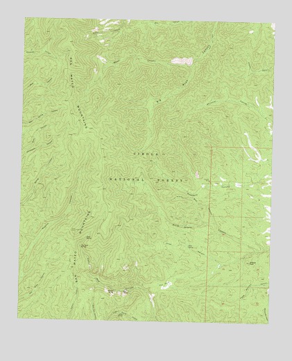
Grassy Lookout, NM USGS Topographic Map
Click on map above to begin viewing in our Map Viewer.

This topographic map contains these locations and features:
Feature Name Type Latitude Longitude GNIS ID View Map
Allen SpringSpringN33.7530°W107.4482°903101View Map
Bear SpringSpringN33.7627°W107.4487°903669View Map
Bell CanyonValleyN33.7909°W107.4039°903727View Map
Bell MineMineN33.8020°W107.4200°903732View Map
Bell SpringSpringN33.8006°W107.4449°913667View Map
Big Rosa TankReservoirN33.8541°W107.3852°913663View Map
Cyanide TankReservoirN33.8078°W107.4008°913660View Map
Dry SpringSpringN33.8321°W107.4379°913672View Map
Exter CanyonValleyN33.7795°W107.3806°906214View Map
Exter SpringSpringN33.7814°W107.4164°906215View Map
Exter TankReservoirN33.7736°W107.4011°913665View Map
Fowler SpringSpringN33.8411°W107.4340°913673View Map
Grassy LookoutPillarN33.7873°W107.4723°906712View Map
Hudson SpringSpringN33.7878°W107.4874°913668View Map
Juniper TankReservoirN33.7966°W107.3781°913664View Map
Lane ProspectMineN33.8398°W107.4084°917403View Map
Lava SpringSpringN33.7843°W107.4673°907901View Map
Leke SpringSpringN33.8596°W107.4443°937070View Map
Narrow SpringSpringN33.7627°W107.4529°909018View Map
New Golden Bell MineMineN33.8020°W107.4200°940049View Map
New Lava SpringSpringN33.7805°W107.4702°909058View Map
Oak SpringSpringN33.7898°W107.4186°909242View Map
Park WellWellN33.7662°W107.4250°913666View Map
Robb ProspectMineN33.8051°W107.4073°917466View Map
Rosedale (historical)Populated PlaceN33.8070°W107.4048°920360View Map
Rosedale MineMineN33.8090°W107.4064°910431View Map
Sanchez Trough SpringSpringN33.8613°W107.4918°913655View Map
Seven SpringSpringN33.8083°W107.4527°913656View Map
Shoe TankReservoirN33.8181°W107.3808°913659View Map
The ParkFlatN33.7648°W107.4270°911645View Map
Tower PeakSummitN33.8653°W107.4775°913670View Map
Trail SpringSpringN33.8089°W107.4721°913671View Map
Upper TankReservoirN33.7706°W107.4041°900262View Map
Water CanyonValleyN33.8565°W107.4167°912173View Map
Water SpringSpringN33.8568°W107.4260°913669View Map
Whitecap TankReservoirN33.8403°W107.3856°913658View Map
Wildcat PeakSummitN33.7751°W107.3856°912383View Map

Note: Coordinates in the location and feature list above are referenced to NAD83 datum.


Copyright (C) 2008-2025 Ryan Niemi / Sunset Dynamics ... All Rights Reserved