TopoQuest Logo
Do you find TopoQuest useful?
Help keep TopoQuest running and adding new maps/features by donating!
Bitcoin:  19c7KJd3qBynnjoSw5npx9KScwjBe4ifkT
Litecoin:  LXs6TkuXGGXo1vDsWCkWVdjQX94eUKd6ui
Home View Maps Find Maps Find Places Resources & Links


Addy, Washington Topographic Map

USGS Map Title: Addy, WA
USGS Map MRC: 48117C7
DRG (GeoTIFF) Download: o48117c7.tif


Neighboring USGS Topographic Map Quads:


  Arden, WA  
48117D8
 

  Addy Mountain, WA  
48117D7
 

  Cliff Ridge, WA  
48117D6
 

  Dunn Mountain, WA  
48117C8
 

  Addy, WA  
48117C7
 

  Chewelah, WA  
48117C6
 

  Stensgar Mountain, WA  
48117B8
 

  Waitts Lake, WA  
48117B7
 

  Valley, WA  
48117B6


Map MRC Location:

N49°
W118°
N49°
W117°
H8 H7 H6 H5 H4 H3 H2 H1
G8 G7 G6 G5 G4 G3 G2 G1
F8 F7 F6 F5 F4 F3 F2 F1
E8 E7 E6 E5 E4 E3 E2 E1
D8 D7 D6 D5 D4 D3 D2 D1
C8 C7 C6 C5 C4 C3 C2 C1
B8 B7 B6 B5 B4 B3 B2 B1
A8 A7 A6 A5 A4 A3 A2 A1
N48°
W118°
N48°
W117°

Addy, WA USGS 1:24K Topographic Map Preview:
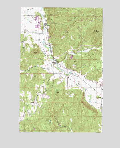
Addy, WA USGS Topographic Map
Click on map above to begin viewing in our Map Viewer.

This topographic map contains these locations and features:
Feature Name Type Latitude Longitude GNIS ID View Map
AddyPopulated PlaceN48.3560°W117.8375°1515727View Map
Addy Census Designated PlaceCensusN48.3589°W117.8372°2586726View Map
Addy CreekStreamN48.3574°W117.8397°1515729View Map
Addy Dolomite QuarryMineN48.3637°W117.8483°2605591View Map
Addy New Life Christian CenterChurchN48.3452°W117.8342°2609216View Map
Addy PitMineN48.3552°W117.8323°2605592View Map
Addy Post OfficePost OfficeN48.3581°W117.8378°2606906View Map
Addy Sewage LagoonLocaleN48.3402°W117.8336°2610627View Map
Alice MineMineN48.3102°W117.7866°1515807View Map
Black Rock QuarryMineN48.3145°W117.7749°2605629View Map
Blue CreekStreamN48.3196°W117.8191°1516673View Map
Blue Creek Station (historical)LocaleN48.3191°W117.8208°1530776View Map
BluecreekPopulated PlaceN48.3188°W117.8211°1516720View Map
Bluecreek AirportAirportN48.3138°W117.8398°2443371View Map
Buck LakeLakeN48.2617°W117.8296°1517038View Map
Checops MineMineN48.2618°W117.8316°1517643View Map
Chewelah Golf and Country ClubLocaleN48.3181°W117.7513°2608384View Map
Country Hills Mobile Home ParkPopulated PlaceN48.3658°W117.8385°2607050View Map
Deer MountainSummitN48.3518°W117.7622°1518646View Map
Doe LakeLakeN48.2609°W117.8272°1518832View Map
Dry CreekStreamN48.3171°W117.8266°1518959View Map
Gold HillSummitN48.3255°W117.7677°1520095View Map
High LakeLakeN48.3507°W117.8056°1520779View Map
Indian CreekStreamN48.3674°W117.8411°1521176View Map
Liberty MineMineN48.3060°W117.8536°1522059View Map
McKale CanyonValleyN48.2546°W117.7994°1522906View Map
Pine HillSummitN48.2846°W117.7566°1524447View Map
Red QuarryLocaleN48.2568°W117.8144°1524953View Map
Riecker MountainSummitN48.3293°W117.8539°1525046View Map
Stensgar CreekStreamN48.3485°W117.8369°1526541View Map
Stevens County Fire District 5 Station 51 AddyBuildingN48.3581°W117.8378°2643969View Map
The Church of Jesus Christ of Latter Day SaintsChurchN48.2955°W117.7532°2609377View Map

Note: Coordinates in the location and feature list above are referenced to NAD83 datum.


Copyright (C) 2008-2025 Ryan Niemi / Sunset Dynamics ... All Rights Reserved