TopoQuest Logo
Do you find TopoQuest useful?
Help keep TopoQuest running and adding new maps/features by donating!
Bitcoin:  19c7KJd3qBynnjoSw5npx9KScwjBe4ifkT
Litecoin:  LXs6TkuXGGXo1vDsWCkWVdjQX94eUKd6ui
Home View Maps Find Maps Find Places Resources & Links


Arden, Washington Topographic Map

USGS Map Title: Arden, WA
USGS Map MRC: 48117D8
DRG (GeoTIFF) Download: o48117d8.tif


Neighboring USGS Topographic Map Quads:


  Kettle Falls, WA  
48118E1
 

  Colville, WA  
48117E8
 

  White Mud Lake, WA  
48117E7
 

  Kentry Ridge, WA  
48118D1
 

  Arden, WA  
48117D8
 

  Addy Mountain, WA  
48117D7
 

  Wellington Peak, WA  
48118C1
 

  Dunn Mountain, WA  
48117C8
 

  Addy, WA  
48117C7


Map MRC Location:

N49°
W118°
N49°
W117°
H8 H7 H6 H5 H4 H3 H2 H1
G8 G7 G6 G5 G4 G3 G2 G1
F8 F7 F6 F5 F4 F3 F2 F1
E8 E7 E6 E5 E4 E3 E2 E1
D8 D7 D6 D5 D4 D3 D2 D1
C8 C7 C6 C5 C4 C3 C2 C1
B8 B7 B6 B5 B4 B3 B2 B1
A8 A7 A6 A5 A4 A3 A2 A1
N48°
W118°
N48°
W117°

Arden, WA USGS 1:24K Topographic Map Preview:
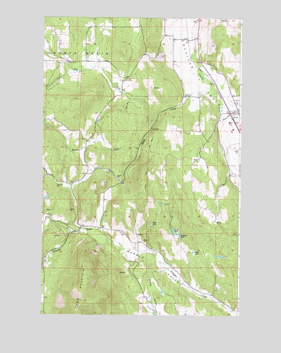
Arden, WA USGS Topographic Map
Click on map above to begin viewing in our Map Viewer.

This topographic map contains these locations and features:
Feature Name Type Latitude Longitude GNIS ID View Map
ArdenPopulated PlaceN48.4602°W117.8764°1515942View Map
Blue LakeLakeN48.4132°W117.9310°1516697View Map
Cole CreekStreamN48.4538°W117.9314°1517945View Map
Cole Creek Picnic AreaLocaleN48.4535°W117.9325°1517947View Map
Erickson LakeLakeN48.4090°W117.9134°1519371View Map
Faith Baptist ChurchChurchN48.4552°W117.8907°2609392View Map
Haller CreekStreamN48.4710°W117.8939°1520472View Map
Ham MineMineN48.4063°W117.9336°1520475View Map
Lenz LakeLakeN48.4104°W117.9173°1522022View Map
Little Pend Oreille RiverStreamN48.4574°W117.8861°1522285View Map
Marble ValleyValleyN48.3766°W117.8783°1522716View Map
North BasinBasinN48.4846°W117.9764°1523721View Map
OrinPopulated PlaceN48.4910°W117.9100°1524072View Map
Panorama Mobile Home ParkPopulated PlaceN48.4839°W117.9266°2607169View Map
Reidel CreekStreamN48.4305°W117.9511°1524988View Map
Rolly LakeLakeN48.4016°W117.9043°1525196View Map
Spratt CreekStreamN48.4452°W117.9394°1526393View Map
Stevens County Fire District 7 Station 71 Arden Fire DepartmentBuildingN48.4608°W117.8811°2606040View Map

Note: Coordinates in the location and feature list above are referenced to NAD83 datum.


Copyright (C) 2008-2025 Ryan Niemi / Sunset Dynamics ... All Rights Reserved