TopoQuest Logo
Do you find TopoQuest useful?
Help keep TopoQuest running and adding new maps/features by donating!
Bitcoin:  19c7KJd3qBynnjoSw5npx9KScwjBe4ifkT
Litecoin:  LXs6TkuXGGXo1vDsWCkWVdjQX94eUKd6ui
Home View Maps Find Maps Find Places Resources & Links


Grayson, Alabama Topographic Map

USGS Map Title: Grayson, AL
USGS Map MRC: 34087C3
DRG (GeoTIFF) Download: o34087c3.tif


Neighboring USGS Topographic Map Quads:


  Landersville, AL  
34087D4
 

  Moulton, AL  
34087D3
 

  Oakville, AL  
34087D2
 

  Bee Branch, AL  
34087C4
 

  Grayson, AL  
34087C3
 

  Upshaw, AL  
34087C2
 

  Double Springs, AL  
34087B4
 

  Houston, AL  
34087B3
 

  Addison, AL  
34087B2


Map MRC Location:

N35°
W88°
N35°
W87°
H8 H7 H6 H5 H4 H3 H2 H1
G8 G7 G6 G5 G4 G3 G2 G1
F8 F7 F6 F5 F4 F3 F2 F1
E8 E7 E6 E5 E4 E3 E2 E1
D8 D7 D6 D5 D4 D3 D2 D1
C8 C7 C6 C5 C4 C3 C2 C1
B8 B7 B6 B5 B4 B3 B2 B1
A8 A7 A6 A5 A4 A3 A2 A1
N34°
W88°
N34°
W87°

Grayson, AL USGS 1:24K Topographic Map Preview:
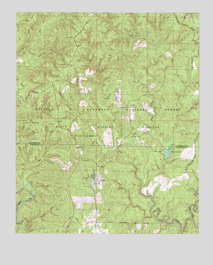
Grayson, AL USGS Topographic Map
Click on map above to begin viewing in our Map Viewer.

This topographic map contains these locations and features:
Feature Name Type Latitude Longitude GNIS ID View Map
Beech CreekStreamN34.2762°W87.2895°159142View Map
Black Warrior Wildlife Management AreaParkN34.3279°W87.3522°159192View Map
Black Warrior Work CenterLocaleN34.3437°W87.3384°163087View Map
Brushy Creek LakeReservoirN34.2961°W87.2712°159257View Map
Brushy Creek Lake DamDamN34.2918°W87.2733°161516View Map
Brushy Creek Recreational AreaParkN34.2973°W87.2703°164521View Map
Bunyan Hill CemeteryCemeteryN34.3123°W87.3706°159273View Map
Central Lookout TowerTowerN34.3454°W87.3386°164301View Map
Cheatham CemeteryCemeteryN34.3268°W87.3158°159377View Map
Church of the ForestChurchN34.2820°W87.3245°159407View Map
Coal BranchStreamN34.3329°W87.2592°159420View Map
Collier CreekStreamN34.2593°W87.2789°159435View Map
Collier Creek CanyonValleyN34.2593°W87.2792°1700528View Map
Collier Creek Post Office (historical)Post OfficeN34.2944°W87.3308°167173View Map
Davis CreekStreamN34.2776°W87.3675°159488View Map
East Fork Beech CreekStreamN34.2976°W87.3072°159546View Map
EllavillePopulated PlaceN34.2573°W87.3200°167169View Map
Ellaville Post Office (historical)Post OfficeN34.2570°W87.3195°167170View Map
Fairview Church (historical)ChurchN34.3612°W87.3339°161823View Map
GraysonPopulated PlaceN34.2804°W87.3195°159693View Map
Grayson LakeReservoirN34.2813°W87.3213°161513View Map
Grayson Lake DamDamN34.2784°W87.3200°161514View Map
Grayson Post Office (historical)Post OfficeN34.2807°W87.3195°167171View Map
Gum Pond (historical)LocaleN34.2959°W87.3539°162085View Map
HepsidamPopulated PlaceN34.3615°W87.3331°161827View Map
Holmes Chapel CemeteryCemeteryN34.2852°W87.2589°2701772View Map
Holmes Chapel School (historical)SchoolN34.2850°W87.2589°2680091View Map
Horse CreekStreamN34.3498°W87.3636°159809View Map
Hunter CampLocaleN34.3373°W87.3461°163086View Map
Hurricane CreekStreamN34.2529°W87.3667°159832View Map
Hurricane Creek Shooting RangeLocaleN34.2604°W87.3370°163090View Map
Key Mill BranchStreamN34.3184°W87.2639°159892View Map
Lloyds CanyonValleyN34.2657°W87.3736°1730277View Map
Lloyds CreekStreamN34.2657°W87.3736°1730278View Map
McDougal Hunter CampLocaleN34.3376°W87.3459°1730239View Map
McDougal RidgeRidgeN34.3320°W87.3403°1730240View Map
McLemore CemeteryCemeteryN34.3609°W87.3358°160077View Map
Montgomery CreekStreamN34.3723°W87.3475°160126View Map
Morgan CemeteryCemeteryN34.2541°W87.3192°2701831View Map
Mount Olive CemeteryCemeteryN34.2911°W87.3286°160160View Map
Mount Olive School (historical)SchoolN34.2906°W87.3269°2680143View Map
Mountain Springs ChurchChurchN34.3709°W87.3653°160195View Map
Oplee Post Office (historical)Post OfficeN34.2861°W87.2533°167168View Map
Owl CreekStreamN34.3001°W87.2697°160329View Map
Owl Post Office (historical)Post OfficeN34.2875°W87.2561°167167View Map
Paines Mill (historical)LocaleN34.2584°W87.2778°1730482View Map
Peters Mill (historical)LocaleN34.3715°W87.3472°161849View Map
Pine Torch ChurchChurchN34.3215°W87.2992°160383View Map
Pine Torch School (historical)SchoolN34.3162°W87.2967°161851View Map
Poplar Springs School (historical)SchoolN34.3693°W87.2634°161857View Map
Rush CreekStreamN34.2582°W87.2547°160543View Map
Shiloh CemeteryCemeteryN34.3581°W87.2506°160598View Map
Shiloh ChurchChurchN34.3582°W87.2514°163195View Map
Tapsville CemeteryCemeteryN34.3476°W87.3339°160714View Map
West Fork Beech CreekStreamN34.2976°W87.3072°160823View Map

Note: Coordinates in the location and feature list above are referenced to NAD83 datum.


Copyright (C) 2008-2025 Ryan Niemi / Sunset Dynamics ... All Rights Reserved