TopoQuest Logo
Do you find TopoQuest useful?
Help keep TopoQuest running and adding new maps/features by donating!
Bitcoin:  19c7KJd3qBynnjoSw5npx9KScwjBe4ifkT
Litecoin:  LXs6TkuXGGXo1vDsWCkWVdjQX94eUKd6ui
Home View Maps Find Maps Find Places Resources & Links


Green Bank, New Jersey Topographic Map

USGS Map Title: Green Bank, NJ
USGS Map MRC: 39074E5
DRG (GeoTIFF) Download: o39074e5.tif


Neighboring USGS Topographic Map Quads:


  Atsion, NJ  
39074F6
 

  Jenkins, NJ  
39074F5
 

  Oswego Lake, NJ  
39074F4
 

  Egg Harbor City, NJ  
39074E6
 

  Green Bank, NJ  
39074E5
 

  New Gretna, NJ  
39074E4
 

  Mays Landing, NJ  
39074D6
 

  Pleasantville, NJ  
39074D5
 

  Oceanville, NJ  
39074D4


Map MRC Location:

N40°
W75°
N40°
W74°
H8 H7 H6 H5 H4 H3 H2 H1
G8 G7 G6 G5 G4 G3 G2 G1
F8 F7 F6 F5 F4 F3 F2 F1
E8 E7 E6 E5 E4 E3 E2 E1
D8 D7 D6 D5 D4 D3 D2 D1
C8 C7 C6 C5 C4 C3 C2 C1
B8 B7 B6 B5 B4 B3 B2 B1
A8 A7 A6 A5 A4 A3 A2 A1
N39°
W75°
N39°
W74°

Green Bank, NJ USGS 1:24K Topographic Map Preview:
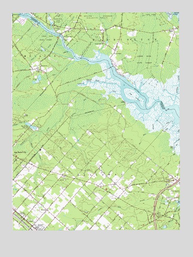
Green Bank, NJ USGS Topographic Map
Click on map above to begin viewing in our Map Viewer.

This topographic map contains these locations and features:
Feature Name Type Latitude Longitude GNIS ID View Map
Boling CemeteryCemeteryN39.5084°W74.5125°874844View Map
Bull CreekStreamN39.6151°W74.5944°875020View Map
City of Egg Harbor CityCivilN39.5640°W74.5961°885204View Map
Clarks LandingPopulated PlaceN39.5737°W74.5402°875459View Map
Clarks MillPopulated PlaceN39.5176°W74.5060°883101View Map
Clarks Mill Burial GroundCemeteryN39.5180°W74.5099°875461View Map
Clarks Mill StreamStreamN39.5157°W74.5034°875462View Map
ColognePopulated PlaceN39.5048°W74.6132°875569View Map
Cologne Post OfficePost OfficeN39.5036°W74.6110°2781419View Map
Egg Harbor City LakeLakeN39.5603°W74.6115°876120View Map
Elliots CreekStreamN39.5530°W74.6123°876157View Map
Fence CreekStreamN39.5610°W74.5045°876318View Map
Galloway Township Fire Department Germania Volunteer Fire CompanyBuildingN39.5107°W74.6004°2401853View Map
GermaniaPopulated PlaceN39.5118°W74.5993°876593View Map
Germania CemeteryCemeteryN39.5304°W74.5865°876594View Map
Germania GardensPopulated PlaceN39.5035°W74.6090°876595View Map
Glouster LandingPopulated PlaceN39.5848°W74.5665°876647View Map
Green BankPopulated PlaceN39.6129°W74.5879°876763View Map
Green Bank Elementary SchoolSchoolN39.6145°W74.5827°2372800View Map
Green Bank State ForestForestN39.5979°W74.5265°876764View Map
Green Bank Volunteer Ambulance CompanyBuildingN39.6139°W74.5847°2660215View Map
Green Bank Volunteer Fire CompanyBuildingN39.6153°W74.5043°2401962View Map
Green Bank Volunteer Fire CompanyBuildingN39.6139°W74.5850°2614382View Map
HermanPopulated PlaceN39.6176°W74.5943°877058View Map
Hog IslandsIslandN39.5771°W74.5335°877158View Map
Indian Cabin CreekStreamN39.5570°W74.6026°877323View Map
Jerry CreekStreamN39.5615°W74.5045°877449View Map
Landing CreekStreamN39.5821°W74.5440°877662View Map
Little Bull CreekStreamN39.6138°W74.5930°877827View Map
Lower BankPopulated PlaceN39.6035°W74.5479°877956View Map
Lower Bank ChurchChurchN39.6079°W74.5571°877957View Map
Lower Bank Volunteer Fire CompanyBuildingN39.6040°W74.5470°2401961View Map
Mill PondLakeN39.5158°W74.5001°878362View Map
Morses Mill StreamStreamN39.5129°W74.5014°878504View Map
Moss Mill LakeReservoirN39.5021°W74.5116°884002View Map
Moss Mill Lake DamDamN39.5026°W74.5104°884003View Map
Negro CreekStreamN39.6063°W74.5874°878700View Map
Otter PondLakeN39.5471°W74.5040°879034View Map
Pacemaker HeliportAirportN39.6085°W74.5713°884816View Map
Pine CreekStreamN39.5974°W74.5758°879297View Map
Richard Stockton State CollegeSchoolN39.5023°W74.5238°883097View Map
Rubins RunStreamN39.5848°W74.5633°879853View Map
Snyder ChurchChurchN39.5921°W74.6029°880674View Map
Swan Bay Wildlife Management AreaParkN39.5751°W74.5038°883024View Map
Tarkiln BranchStreamN39.5679°W74.5115°881088View Map
Teal CreekStreamN39.5782°W74.5436°881110View Map
The Pilgrim Academy SchoolSchoolN39.5170°W74.5396°2333366View Map
Turtle CreekStreamN39.5719°W74.5047°881302View Map
Union CreekStreamN39.5479°W74.6246°881350View Map
UnionvillePopulated PlaceN39.5271°W74.5013°882940View Map
Vienna GardensPopulated PlaceN39.5112°W74.6224°881453View Map
Wading RiverPopulated PlaceN39.6154°W74.5040°881484View Map
WeekstownPopulated PlaceN39.5921°W74.6029°881648View Map
Weekstown Volunteer Fire CompanyBuildingN39.5916°W74.6026°2401861View Map
Winchelsea AirportAirportN39.5184°W74.5094°884898View Map

Note: Coordinates in the location and feature list above are referenced to NAD83 datum.


Copyright (C) 2008-2025 Ryan Niemi / Sunset Dynamics ... All Rights Reserved