TopoQuest Logo
Do you find TopoQuest useful?
Help keep TopoQuest running and adding new maps/features by donating!
Bitcoin:  19c7KJd3qBynnjoSw5npx9KScwjBe4ifkT
Litecoin:  LXs6TkuXGGXo1vDsWCkWVdjQX94eUKd6ui
Home View Maps Find Maps Find Places Resources & Links


Oceanville, New Jersey Topographic Map

USGS Map Title: Oceanville, NJ
USGS Map MRC: 39074D4
DRG (GeoTIFF) Download: o39074d4.tif


Neighboring USGS Topographic Map Quads:


  Green Bank, NJ  
39074E5
 

  New Gretna, NJ  
39074E4
 

  Tuckerton, NJ  
39074E3
 

  Pleasantville, NJ  
39074D5
 

  Oceanville, NJ  
39074D4
 

  Brigantine Inlet, NJ  
39074D3
 

  Ocean City, NJ  
39074C5
 

  Atlantic City, NJ  
39074C4


Map MRC Location:

N40°
W75°
N40°
W74°
H8 H7 H6 H5 H4 H3 H2 H1
G8 G7 G6 G5 G4 G3 G2 G1
F8 F7 F6 F5 F4 F3 F2 F1
E8 E7 E6 E5 E4 E3 E2 E1
D8 D7 D6 D5 D4 D3 D2 D1
C8 C7 C6 C5 C4 C3 C2 C1
B8 B7 B6 B5 B4 B3 B2 B1
A8 A7 A6 A5 A4 A3 A2 A1
N39°
W75°
N39°
W74°

Oceanville, NJ USGS 1:24K Topographic Map Preview:
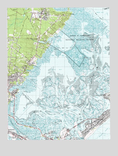
Oceanville, NJ USGS Topographic Map
Click on map above to begin viewing in our Map Viewer.

This topographic map contains these locations and features:
Feature Name Type Latitude Longitude GNIS ID View Map
AbseconPopulated PlaceN39.4285°W74.4957°874242View Map
Absecon BayBayN39.4087°W74.4729°874243View Map
Absecon ChannelChannelN39.3957°W74.4332°874244View Map
Absecon CreekStreamN39.4204°W74.4813°874245View Map
Absecon HighlandsPopulated PlaceN39.4468°W74.4740°874247View Map
Absecon InletGutN39.3760°W74.4129°874248View Map
Absecon State Wildlife Management AreaParkN39.4057°W74.4371°873911View Map
Absecon State Wildlife Management AreasParkN39.4282°W74.3813°874203View Map
Assumption Regional Catholic SchoolSchoolN39.4758°W74.4911°2333284View Map
Bayview Volunteer Fire Company Station 26 - 4BuildingN39.4387°W74.4813°2401864View Map
Big Fish ThorofareChannelN39.4132°W74.4243°874749View Map
Black PointCapeN39.4435°W74.3932°874788View Map
Bonita TidewayChannelN39.4015°W74.3832°874851View Map
Boot IslandIslandN39.3968°W74.4060°874856View Map
Brigantine BeachBeachN39.3928°W74.3792°874937View Map
Broad CreekStreamN39.4912°W74.3956°874914View Map
Broad CreekChannelN39.4029°W74.4246°874950View Map
City of AbseconCivilN39.4228°W74.4944°885134View Map
City of Atlantic CityCivilN39.3776°W74.4516°885142View Map
City of BrigantineCivilN39.4136°W74.3785°885171View Map
Clam CreekStreamN39.3779°W74.4210°875442View Map
Clam ThorofareChannelN39.3787°W74.4382°875444View Map
Coast Guard Station Atlantic CityMilitaryN39.3784°W74.4234°2512411View Map
Conover ChannelChannelN39.4321°W74.4476°875606View Map
ConovertownPopulated PlaceN39.4398°W74.4785°875607View Map
Cordery CreekStreamN39.4366°W74.4627°875651View Map
Cordery ThorofareChannelN39.4260°W74.4501°875652View Map
Doles PointCapeN39.3996°W74.4429°875938View Map
Doughty CreekStreamN39.4573°W74.4404°875952View Map
Duck ThorofareChannelN39.3857°W74.4554°875996View Map
Eagle BayBayN39.4068°W74.4015°876028View Map
East Point ChannelChannelN39.4298°W74.4374°876063View Map
Emma C Attales SchoolSchoolN39.4368°W74.4946°874052View Map
Emma C Attales SchoolSchoolN39.4368°W74.4949°873916View Map
Flat CreekStreamN39.3882°W74.4685°876376View Map
Flat ThorofareChannelN39.4221°W74.4154°876380View Map
Forty-fourth Street PierLocaleN39.3857°W74.3907°876427View Map
Galloway Community Charter SchoolSchoolN39.4812°W74.4593°2333431View Map
Galloway Township Ambulance Squad Station 2BuildingN39.4647°W74.4992°2660170View Map
Galloway Township Police DepartmentBuildingN39.4645°W74.4993°2730968View Map
Golden Hammock ThorofareChannelN39.3957°W74.4004°876659View Map
Grassy BayBayN39.4348°W74.3971°876716View Map
Green Acres ParkParkN39.4382°W74.4968°874051View Map
Green Acres ParkParkN39.4382°W74.4974°873914View Map
Gull Island ThorofareChannelN39.4171°W74.4279°876846View Map
H Ashton Marsh Elementary SchoolSchoolN39.4370°W74.4956°2333333View Map
Hammock CoveBayN39.4751°W74.4032°873918View Map
Harrahs Landing Seaplane BaseAirportN39.3862°W74.4254°884653View Map
Highland Academy SchoolSchoolN39.4946°W74.4684°2333230View Map
Jonathan ThorofareChannelN39.3865°W74.4865°877483View Map
Lakes BayBayN39.3779°W74.4968°873910View Map
Leeds PointPopulated PlaceN39.4921°W74.4290°877726View Map
Leeds Point Post OfficePost OfficeN39.4908°W74.4361°2781443View Map
Lily LakeReservoirN39.4678°W74.4583°877758View Map
Lily Lake DamDamN39.4671°W74.4549°884174View Map
Little BayBayN39.3812°W74.4685°877820View Map
Little BayBayN39.4540°W74.3785°877821View Map
Little PanamaChannelN39.3907°W74.4196°874053View Map
Little PanamaGutN39.3918°W74.4190°873912View Map
Low Water ThorofareChannelN39.3957°W74.4229°877952View Map
Main Marsh CreekStreamN39.4873°W74.3865°878035View Map
Main Marsh ThorofareChannelN39.4782°W74.3807°878036View Map
Mainland Baptist Christian SchoolSchoolN39.4510°W74.4955°2333242View Map
Mainland ChurchChurchN39.4510°W74.4954°874050View Map
Mainland ChurchChurchN39.4510°W74.4960°873915View Map
Mankiller BayBayN39.3979°W74.4329°878071View Map
Mankiller IslandIslandN39.3926°W74.4349°878072View Map
Meadow CutChannelN39.4348°W74.4082°878236View Map
Middle ThorofareChannelN39.4021°W74.4335°878306View Map
Mud Creek (historical)StreamN39.3854°W74.4249°878629View Map
New Jersey State Police Marine Services BureauBuildingN39.3787°W74.4243°2730510View Map
Newfound ThorofareChannelN39.3832°W74.4671°878780View Map
Obes ThorofareChannelN39.4198°W74.3768°878934View Map
OceanvillePopulated PlaceN39.4712°W74.4604°878942View Map
Oceanville Kindergarten Learning Center SchoolSchoolN39.4638°W74.4633°2333243View Map
Oceanville Post OfficePost OfficeN39.4728°W74.4598°2781472View Map
Oceanville Volunteer Fire Company 1BuildingN39.4708°W74.4607°2401542View Map
Oyster ThorofareChannelN39.4315°W74.4088°879079View Map
Perch CoveBayN39.4582°W74.4035°879234View Map
Peter BeachBeachN39.3921°W74.4007°879248View Map
Point Bar ThorofareChannelN39.3929°W74.4376°879389View Map
Reeds BayBayN39.4418°W74.4376°879648View Map
Roundabout ThorofareChannelN39.4237°W74.4063°879841View Map
Rubes CreekStreamN39.4771°W74.4135°874198View Map
Rum PointCapeN39.3835°W74.4168°879858View Map
Saint Philip SchoolSchoolN39.3898°W74.3932°874054View Map
Saint Phillip SchoolSchoolN39.3901°W74.3932°873913View Map
Sand ThorofareChannelN39.4035°W74.3896°880254View Map
Scott LandingLocaleN39.4951°W74.4210°874055View Map
Seaview Country ClubLocaleN39.4493°W74.4729°884489View Map
Seaview ParkPopulated PlaceN39.4423°W74.4774°880452View Map
Shad IslandIslandN39.4618°W74.3896°880491View Map
Sheepshank ThorofareChannelN39.4157°W74.4321°880531View Map
Sloop ThorofareChannelN39.4296°W74.4476°880647View Map
SmithvillePopulated PlaceN39.4940°W74.4571°880666View Map
Smithville Airport (historical)AirportN39.4912°W74.4710°882384View Map
Smithville Census Designated PlaceCensusN39.4934°W74.4781°2584030View Map
Smithville Elementary SchoolSchoolN39.4900°W74.4755°2333204View Map
Somers CoveBayN39.4554°W74.4438°880689View Map
Stake ThorofareChannelN39.4137°W74.4135°880847View Map
State MarinaHarborN39.3779°W74.4268°882867View Map
Steelman ThorofareChannelN39.4160°W74.4479°880875View Map
Sunflower IslandIslandN39.3951°W74.4124°880999View Map
Township of GallowayCivilN39.4906°W74.4742°882052View Map
Trumps Castle HeliportAirportN39.3796°W74.4271°884652View Map
Turtle CoveBayN39.4551°W74.4315°881299View Map
Venice ParkPopulated PlaceN39.3765°W74.4451°883307View Map
Venice Park Elementary SchoolSchoolN39.3755°W74.4485°2333351View Map
Wading ThorofareChannelN39.4137°W74.3871°881486View Map
WAYV-FM (Atlantic City)TowerN39.3809°W74.4507°884597View Map
Weakfish IslandIslandN39.4060°W74.4590°881636View Map
West Atlantic CityPopulated PlaceN39.3779°W74.4893°881675View Map
WFPG Radio Tower (Conway)TowerN39.3790°W74.4474°874049View Map
WFPG-AM (Atlantic City)TowerN39.3785°W74.4476°884566View Map
WFPG-FM (Atlantic City)TowerN39.3785°W74.4476°884596View Map
WGRF Radio Tower (Conway)TowerN39.3762°W74.4515°874048View Map
Wills ThorofareChannelN39.4071°W74.4521°881864View Map
WMID-AM (Atlantic City)TowerN39.3765°W74.4518°884567View Map
WMID-FM (Pleasantville)TowerN39.3765°W74.4518°884626View Map
WWAC Radio Tower (Conway)TowerN39.3812°W74.4499°874047View Map
WWAC-TV (Atlantic City)TowerN39.3809°W74.4504°884635View Map

Note: Coordinates in the location and feature list above are referenced to NAD83 datum.


Copyright (C) 2008-2024 Ryan Niemi / Sunset Dynamics ... All Rights Reserved