TopoQuest Logo
Do you find TopoQuest useful?
Help keep TopoQuest running and adding new maps/features by donating!
Bitcoin:  19c7KJd3qBynnjoSw5npx9KScwjBe4ifkT
Litecoin:  LXs6TkuXGGXo1vDsWCkWVdjQX94eUKd6ui
Home View Maps Find Maps Find Places Resources & Links


New Gretna, New Jersey Topographic Map

USGS Map Title: New Gretna, NJ
USGS Map MRC: 39074E4
DRG (GeoTIFF) Download: o39074e4.tif


Neighboring USGS Topographic Map Quads:


  Jenkins, NJ  
39074F5
 

  Oswego Lake, NJ  
39074F4
 

  West Creek, NJ  
39074F3
 

  Green Bank, NJ  
39074E5
 

  New Gretna, NJ  
39074E4
 

  Tuckerton, NJ  
39074E3
 

  Pleasantville, NJ  
39074D5
 

  Oceanville, NJ  
39074D4
 

  Brigantine Inlet, NJ  
39074D3


Map MRC Location:

N40°
W75°
N40°
W74°
H8 H7 H6 H5 H4 H3 H2 H1
G8 G7 G6 G5 G4 G3 G2 G1
F8 F7 F6 F5 F4 F3 F2 F1
E8 E7 E6 E5 E4 E3 E2 E1
D8 D7 D6 D5 D4 D3 D2 D1
C8 C7 C6 C5 C4 C3 C2 C1
B8 B7 B6 B5 B4 B3 B2 B1
A8 A7 A6 A5 A4 A3 A2 A1
N39°
W75°
N39°
W74°

New Gretna, NJ USGS 1:24K Topographic Map Preview:
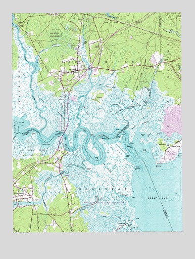
New Gretna, NJ USGS Topographic Map
Click on map above to begin viewing in our Map Viewer.

This topographic map contains these locations and features:
Feature Name Type Latitude Longitude GNIS ID View Map
Akimbo PointCapeN39.5535°W74.4340°874266View Map
Ballinger CreekStreamN39.5601°W74.4152°874476View Map
Bass RiverStreamN39.5602°W74.4501°874534View Map
Bass RiverPopulated PlaceN39.5926°W74.4426°882936View Map
Bass River NeckCapeN39.5668°W74.4635°883023View Map
Bass River Township Elementary SchoolSchoolN39.5943°W74.4520°2045922View Map
Basses BayBayN39.5551°W74.4035°874536View Map
Big CreekStreamN39.5546°W74.4985°874746View Map
Big Graveling CreekGutN39.5329°W74.4299°874753View Map
Blood DitchCanalN39.5548°W74.4410°874815View Map
Blood PointCapeN39.5437°W74.4365°874816View Map
Bogans CoveBayN39.5435°W74.3754°874838View Map
Brigantine National Wildlife RefugeParkN39.5157°W74.4326°874940View Map
Brigantine WildernessReserveN39.5344°W74.4264°2035536View Map
Broad CreekStreamN39.5771°W74.4460°874951View Map
Bubs CreekStreamN39.5572°W74.4992°874996View Map
Chestnut NeckCapeN39.5393°W74.4802°875408View Map
Chestnut Neck Battle MonumentParkN39.5446°W74.4613°875409View Map
City of Port RepublicCivilN39.5328°W74.4852°885360View Map
Collins CoveBayN39.5490°W74.4746°875564View Map
Collins PointCapeN39.5565°W74.4857°875566View Map
Cramer CreekStreamN39.5666°W74.4544°875692View Map
Deep PointCapeN39.5518°W74.4124°875848View Map
Doctors PointCapeN39.5557°W74.4274°882937View Map
East Branch Bass RiverStreamN39.6157°W74.4465°876039View Map
First Presbyterian ChurchChurchN39.5954°W74.4518°2045925View Map
Fish CreekStreamN39.5696°W74.4181°876350View Map
Goose CoveBayN39.5421°W74.4143°876674View Map
Graveling PointCapeN39.5382°W74.3935°876724View Map
Great BayBayN39.5126°W74.3771°876734View Map
HigbeevillePopulated PlaceN39.5154°W74.4565°882656View Map
Hillside CemeteryCemeteryN39.5900°W74.4654°877127View Map
Interchange 48CrossingN39.5473°W74.4668°2045918View Map
Interchange 50CrossingN39.5804°W74.4577°2045923View Map
Interchange 52CrossingN39.6046°W74.4351°2045924View Map
Ives BranchStreamN39.6112°W74.4943°877376View Map
Jobs CreekStreamN39.5832°W74.4401°877461View Map
JohnsontownPopulated PlaceN39.5237°W74.4599°882938View Map
Judies CreekStreamN39.5528°W74.4021°877496View Map
Landing CreekStreamN39.5021°W74.4076°877661View Map
Leek-McKeen CemeteryCemeteryN39.6196°W74.4963°877727View Map
LeektownPopulated PlaceN39.6246°W74.4671°877728View Map
Loveland ThorofareChannelN39.5682°W74.4518°877951View Map
Lower Pasture CreekStreamN39.5807°W74.3979°877971View Map
Mathis ThorofareChannelN39.5694°W74.4292°878187View Map
Mattix RunStreamN39.5195°W74.4780°878192View Map
MerrygoldPopulated PlaceN39.6062°W74.4504°882908View Map
Merrygold BranchStreamN39.5962°W74.4813°878270View Map
Miller CemeteryCemeteryN39.5943°W74.4480°878373View Map
Moss PointCapeN39.5582°W74.4496°882020View Map
Mott CreekStreamN39.5190°W74.4135°878510View Map
Mullica RiverStreamN39.5479°W74.4142°878659View Map
Mystic IslandPopulated PlaceN39.5443°W74.3824°878679View Map
Mystic Island Census Designated PlaceCensusN39.5659°W74.3831°2389525View Map
Nacote CreekStreamN39.5416°W74.4451°878681View Map
New GretnaPopulated PlaceN39.5923°W74.4510°878737View Map
New Gretna Volunteer Fire CompanyBuildingN39.5933°W74.4515°2401730View Map
New Jersey State Police Troop E Bass River StationBuildingN39.6056°W74.4339°2731043View Map
Oak IslandIslandN39.5776°W74.4360°878906View Map
Osborne IslandIslandN39.5490°W74.3788°879022View Map
Oyster CreekPopulated PlaceN39.5043°W74.4165°879069View Map
Oyster CreekStreamN39.5073°W74.4104°879072View Map
Oysterbed PointCapeN39.5354°W74.4099°879080View Map
Pollys DitchCanalN39.5746°W74.4018°879410View Map
Port RepublicPopulated PlaceN39.5207°W74.4857°879446View Map
Port Republic Elementary SchoolSchoolN39.5207°W74.4948°2045919View Map
Port Republic Volunteer Fire CompanyBuildingN39.5227°W74.4914°2401827View Map
Port Republic Wildlife Management AreaParkN39.5454°W74.4854°879447View Map
Quaker DitchCanalN39.5357°W74.4454°879562View Map
Roundabout CreekStreamN39.5565°W74.4074°879840View Map
Saint Pauls Methodist ChurchChurchN39.5915°W74.4554°880156View Map
Saint Pauls United Methodist ChurchChurchN39.5198°W74.4927°2045917View Map
Swan BayBayN39.5621°W74.4915°881037View Map
Swimming Over PointCapeN39.5548°W74.4190°881060View Map
Turtle IslandIslandN39.5460°W74.4018°881307View Map
Wading RiverStreamN39.5573°W74.4793°881485View Map
Wells IslandIslandN39.5496°W74.3893°881660View Map
West Branch Bass RiverStreamN39.6158°W74.4468°881679View Map
Wigwam CreekStreamN39.5180°W74.4360°881823View Map
Winter CreekStreamN39.5593°W74.4149°881888View Map
Wolf RunStreamN39.5838°W74.4334°881896View Map
Worlds End CreekStreamN39.5696°W74.4085°881954View Map

Note: Coordinates in the location and feature list above are referenced to NAD83 datum.


Copyright (C) 2008-2024 Ryan Niemi / Sunset Dynamics ... All Rights Reserved