TopoQuest Logo
Do you find TopoQuest useful?
Help keep TopoQuest running and adding new maps/features by donating!
Bitcoin:  19c7KJd3qBynnjoSw5npx9KScwjBe4ifkT
Litecoin:  LXs6TkuXGGXo1vDsWCkWVdjQX94eUKd6ui
Home View Maps Find Maps Find Places Resources & Links


Green Valley, Texas Topographic Map

USGS Map Title: Green Valley, TX
USGS Map MRC: 33097C1
DRG (GeoTIFF) Download: o33097c1.tif


Neighboring USGS Topographic Map Quads:


  Valley View, TX  
33097D2
 

  Mountain Springs, TX  
33097D1
 

  Pilot Point, TX  
33096D8
 

  Sanger, TX  
33097C2
 

  Green Valley, TX  
33097C1
 

  Aubrey, TX  
33096C8
 

  Denton West, TX  
33097B2
 

  Denton East, TX  
33097B1
 

  Little Elm, TX  
33096B8


Map MRC Location:

N34°
W98°
N34°
W97°
H8 H7 H6 H5 H4 H3 H2 H1
G8 G7 G6 G5 G4 G3 G2 G1
F8 F7 F6 F5 F4 F3 F2 F1
E8 E7 E6 E5 E4 E3 E2 E1
D8 D7 D6 D5 D4 D3 D2 D1
C8 C7 C6 C5 C4 C3 C2 C1
B8 B7 B6 B5 B4 B3 B2 B1
A8 A7 A6 A5 A4 A3 A2 A1
N33°
W98°
N33°
W97°

Green Valley, TX USGS 1:24K Topographic Map Preview:
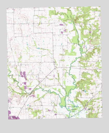
Green Valley, TX USGS Topographic Map
Click on map above to begin viewing in our Map Viewer.

This topographic map contains these locations and features:
Feature Name Type Latitude Longitude GNIS ID View Map
Aubrey BranchStreamN33.3087°W97.0408°1351327View Map
Bray BranchStreamN33.3221°W97.0267°1352844View Map
Campbell FieldAirportN33.3231°W97.0455°2675756View Map
Clear CreekStreamN33.2643°W97.0486°1381661View Map
Crains LakeReservoirN33.2802°W97.0230°1355305View Map
Culp BranchStreamN33.2760°W97.0464°1355463View Map
Davis CemeteryCemeteryN33.3559°W97.0481°1355698View Map
Evans LakeReservoirN33.2751°W97.0903°1855485View Map
Evans Lake DamDamN33.2751°W97.0903°1855484View Map
First Church of the NazareneChurchN33.2548°W97.1197°2018307View Map
Ginnings Elementary SchoolSchoolN33.2532°W97.1214°2004016View Map
Green ValleyPopulated PlaceN33.3134°W97.0642°1379857View Map
Harmony RanchLocaleN33.2604°W97.0158°1358817View Map
Hartlee FieldAirportN33.2693°W97.0808°1386543View Map
Hodge Elementary SchoolSchoolN33.2515°W97.0895°2003962View Map
Isle du Bois CreekStreamN33.3618°W97.0375°1388228View Map
McCallum LakeReservoirN33.3464°W97.0147°1863860View Map
McCallum Lake DamDamN33.3468°W97.0136°1863859View Map
Milam CreekStreamN33.2796°W97.1003°1362821View Map
Ray Roberts Greenbelt Corridor TrailTrailN33.3365°W97.0303°2033270View Map
Ray Roberts LakeReservoirN33.3334°W97.0300°1377269View Map
Ray Roberts Lake State Recreation Area - Culp Branch UnitParkN33.3537°W97.0867°2029527View Map
Rock Hill ChurchChurchN33.2773°W97.0131°1366663View Map
Smither FieldAirportN33.3097°W97.0935°2675961View Map
Twin Lakes Number 1ReservoirN33.2708°W97.1249°1863862View Map
Vultures Row AirportAirportN33.3400°W97.1031°2675869View Map
Warschun Ranch AirportAirportN33.3009°W97.1129°1386544View Map
Windy Hill Airport (historical)AirportN33.3127°W97.1018°1386546View Map

Note: Coordinates in the location and feature list above are referenced to NAD83 datum.


Copyright (C) 2008-2025 Ryan Niemi / Sunset Dynamics ... All Rights Reserved