TopoQuest Logo
Do you find TopoQuest useful?
Help keep TopoQuest running and adding new maps/features by donating!
Bitcoin:  19c7KJd3qBynnjoSw5npx9KScwjBe4ifkT
Litecoin:  LXs6TkuXGGXo1vDsWCkWVdjQX94eUKd6ui
Home View Maps Find Maps Find Places Resources & Links


Mountain Springs, Texas Topographic Map

USGS Map Title: Mountain Springs, TX
USGS Map MRC: 33097D1
DRG (GeoTIFF) Download: o33097d1.tif


Neighboring USGS Topographic Map Quads:


  Gainesville South, TX  
33097E2
 

  Woodbine, TX  
33097E1
 

  Collinsville, TX  
33096E8
 

  Valley View, TX  
33097D2
 

  Mountain Springs, TX  
33097D1
 

  Pilot Point, TX  
33096D8
 

  Sanger, TX  
33097C2
 

  Green Valley, TX  
33097C1
 

  Aubrey, TX  
33096C8


Map MRC Location:

N34°
W98°
N34°
W97°
H8 H7 H6 H5 H4 H3 H2 H1
G8 G7 G6 G5 G4 G3 G2 G1
F8 F7 F6 F5 F4 F3 F2 F1
E8 E7 E6 E5 E4 E3 E2 E1
D8 D7 D6 D5 D4 D3 D2 D1
C8 C7 C6 C5 C4 C3 C2 C1
B8 B7 B6 B5 B4 B3 B2 B1
A8 A7 A6 A5 A4 A3 A2 A1
N33°
W98°
N33°
W97°

Mountain Springs, TX USGS 1:24K Topographic Map Preview:
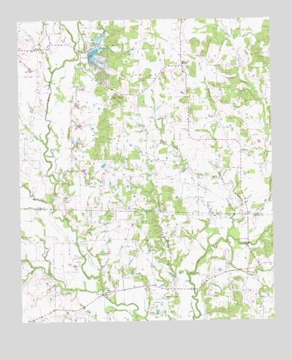
Mountain Springs, TX USGS Topographic Map
Click on map above to begin viewing in our Map Viewer.

This topographic map contains these locations and features:
Feature Name Type Latitude Longitude GNIS ID View Map
Belcher Airport (historical)AirportN33.3826°W97.1075°1387493View Map
BloomfieldPopulated PlaceN33.4446°W97.0156°1379431View Map
Bloomfield CemeteryCemeteryN33.4371°W97.0242°1352428View Map
Elm Fork Greenbelt TrailTrailN33.3807°W97.0220°2032816View Map
HemmingPopulated PlaceN33.4315°W97.0858°1379920View Map
Jacobs Oil FieldOilfieldN33.4248°W97.0381°1360128View Map
Johnson BranchStreamN33.3943°W97.0408°1360318View Map
Johnson FarmLocaleN33.4179°W97.0483°2032066View Map
Jones FarmLocaleN33.4148°W97.0442°2032067View Map
Jordon Park TrailTrailN33.4012°W97.0061°2033454View Map
Lick CreekStreamN33.4340°W97.0264°1361175View Map
Melody Ranch AirportAirportN33.4645°W97.0698°2676597View Map
Mount OliveSummitN33.4682°W97.0770°1364523View Map
Mount Olive CemeteryCemeteryN33.4665°W97.0767°1363280View Map
Mount Pleasant ChurchChurchN33.4540°W97.0414°1363314View Map
Mountain SpringsPopulated PlaceN33.4804°W97.0439°1363383View Map
Mountain Springs (historical)SpringN33.4584°W97.0420°1998677View Map
New Hope CemeteryCemeteryN33.4954°W97.0453°1363722View Map
Oak Hill CemeteryCemeteryN33.4596°W97.0495°1364286View Map
Pecan CreekStreamN33.4484°W97.1122°1364968View Map
Persimmon CreekStreamN33.4859°W97.0950°1365092View Map
Pond CreekStreamN33.3879°W97.0850°1365556View Map
Ray Roberts Lake State Park - Isle Du Bois UnitParkN33.3840°W97.0170°2029525View Map
Ray Roberts Lake State Park - Johnson Branch UnitParkN33.3998°W97.0611°2029526View Map
Sand BranchStreamN33.4082°W97.0231°1367572View Map
Soil Conservation Service Site 18 DamDamN33.4851°W97.0903°1855284View Map
Soil Conservation Service Site 61t DamDamN33.4718°W97.0936°1855288View Map
Soil Conservation Service Site 61t ReservoirReservoirN33.4718°W97.0936°1855289View Map
Soil Conservation Service Site 61u DamDamN33.4651°W97.0970°1855286View Map
Soil Conservation Service Site 61u ReservoirReservoirN33.4651°W97.0970°1855287View Map
Soil Conservation Service Site 61v DamDamN33.4584°W97.0970°1855282View Map
Soil Conservation Service Site 61v ReservoirReservoirN33.4584°W97.0970°1855283View Map
Soil Conservation Service Site 61w DamDamN33.4484°W97.0986°1855280View Map
Soil Conservation Service Site 61w ReservoirReservoirN33.4484°W97.0986°1855281View Map
Soil Conservation Service Site 61x DamDamN33.4384°W97.0953°1855278View Map
Soil Conservation Service Site 61x ReservoirReservoirN33.4384°W97.0953°1855279View Map
Soil Conservation Service Site Number 18 ReservoirReservoirN33.4851°W97.0903°1855285View Map
Spring CreekStreamN33.4243°W97.1097°1368982View Map
Tailwheel Acres AirportAirportN33.4745°W97.1229°2675783View Map
Tipps LakeReservoirN33.4784°W97.1186°1864983View Map
Tipps Lake DamDamN33.4784°W97.1186°1864982View Map
Tyson CemeteryCemeteryN33.4162°W97.0661°1370418View Map
Walling CemeteryCemeteryN33.4654°W97.0142°1370796View Map
Walnut BranchStreamN33.4098°W97.0222°1370801View Map

Note: Coordinates in the location and feature list above are referenced to NAD83 datum.


Copyright (C) 2008-2025 Ryan Niemi / Sunset Dynamics ... All Rights Reserved