TopoQuest Logo
Do you find TopoQuest useful?
Help keep TopoQuest running and adding new maps/features by donating!
Bitcoin:  19c7KJd3qBynnjoSw5npx9KScwjBe4ifkT
Litecoin:  LXs6TkuXGGXo1vDsWCkWVdjQX94eUKd6ui
Home View Maps Find Maps Find Places Resources & Links


Greenfield, Arkansas Topographic Map

USGS Map Title: Greenfield, AR
USGS Map MRC: 35090F6
DRG (GeoTIFF) Download: o35090f6.tif


Neighboring USGS Topographic Map Quads:


  Herman, AR  
35090G7
 

  Jonesboro, AR  
35090G6
 

  Needham, AR  
35090G5
 

  Otwell, AR  
35090F7
 

  Greenfield, AR  
35090F6
 

  Trumann, AR  
35090F5
 

  Powers Slough, AR  
35090E7
 

  Harrisburg, AR  
35090E6
 

  McCormick, AR  
35090E5


Map MRC Location:

N36°
W91°
N36°
W90°
H8 H7 H6 H5 H4 H3 H2 H1
G8 G7 G6 G5 G4 G3 G2 G1
F8 F7 F6 F5 F4 F3 F2 F1
E8 E7 E6 E5 E4 E3 E2 E1
D8 D7 D6 D5 D4 D3 D2 D1
C8 C7 C6 C5 C4 C3 C2 C1
B8 B7 B6 B5 B4 B3 B2 B1
A8 A7 A6 A5 A4 A3 A2 A1
N35°
W91°
N35°
W90°

Greenfield, AR USGS 1:24K Topographic Map Preview:
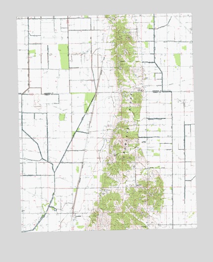
Greenfield, AR USGS Topographic Map
Click on map above to begin viewing in our Map Viewer.

This topographic map contains these locations and features:
Feature Name Type Latitude Longitude GNIS ID View Map
Alsup ChurchChurchN35.7337°W90.6432°64548View Map
Barker CreekStreamN35.6579°W90.6418°46036View Map
Brett School (historical)SchoolN35.6273°W90.6512°82740View Map
Buffalolick (historical)Populated PlaceN35.6640°W90.6843°65764View Map
CaryPopulated PlaceN35.7201°W90.6882°57520View Map
Central Elementary SchoolSchoolN35.6758°W90.6606°76578View Map
Central Volunteer Fire DepartmentBuildingN35.6694°W90.6590°2116255View Map
County Line ChurchChurchN35.7056°W90.6621°48090View Map
Ditch Number 7CanalN35.6667°W90.6340°82371View Map
Ganaway CreekStreamN35.6892°W90.6432°49320View Map
GaulettPopulated PlaceN35.6504°W90.7101°57803View Map
GreenfieldPopulated PlaceN35.6323°W90.7126°77071View Map
Greenfield Baptist ChurchChurchN35.6351°W90.7112°65782View Map
Houston CemeteryCemeteryN35.6687°W90.6834°65820View Map
Hy-Way Valley ChurchChurchN35.6267°W90.6612°77170View Map
KWEZ-FM (Trumann)TowerN35.7476°W90.6304°85433View Map
Lateral Number 1CanalN35.6906°W90.7051°82471View Map
Lateral Number 3CanalN35.7262°W90.6982°82485View Map
Legacy LandfillLocaleN35.7122°W90.6861°2726688View Map
Lonnie Jaynes LakeReservoirN35.6351°W90.6518°80069View Map
Lonnie Jaynes Lake DamDamN35.6351°W90.6518°80068View Map
Main Ditch Number 1CanalN35.7198°W90.7023°82510View Map
Main Ditch Number 2CanalN35.7162°W90.7423°82511View Map
Morning Sun School (historical)SchoolN35.6851°W90.6732°82754View Map
Mount Pisgah CemeteryCemeteryN35.7215°W90.6787°52377View Map
Mount Pisgah ChurchChurchN35.7226°W90.6784°77733View Map
MulliganPopulated PlaceN35.7015°W90.6962°58232View Map
Oakview ChurchChurchN35.6362°W90.7493°52971View Map
Pine View School (historical)SchoolN35.6462°W90.6596°82758View Map
Pisgah School (historical)SchoolN35.7190°W90.6698°78945View Map
Pleasant Grove Baptist ChurchChurchN35.6492°W90.6687°82821View Map
RidgePopulated PlaceN35.7473°W90.6871°78177View Map
Ridge Station School (historical)SchoolN35.7459°W90.6818°75334View Map
Southridge Fire Department Station 1BuildingN35.7447°W90.6658°2117151View Map
Township of GreenfieldCivilN35.7391°W90.6583°66459View Map
Township of GreenfieldCivilN35.6633°W90.7129°68975View Map
White CemeteryCemeteryN35.7128°W90.6615°56248View Map
Willis CemeteryCemeteryN35.6623°W90.6718°56410View Map
Wilson CemeteryCemeteryN35.6462°W90.6932°77242View Map

Note: Coordinates in the location and feature list above are referenced to NAD83 datum.


Copyright (C) 2008-2025 Ryan Niemi / Sunset Dynamics ... All Rights Reserved