TopoQuest Logo
Do you find TopoQuest useful?
Help keep TopoQuest running and adding new maps/features by donating!
Bitcoin:  19c7KJd3qBynnjoSw5npx9KScwjBe4ifkT
Litecoin:  LXs6TkuXGGXo1vDsWCkWVdjQX94eUKd6ui
Home View Maps Find Maps Find Places Resources & Links


Harrisburg, Arkansas Topographic Map

USGS Map Title: Harrisburg, AR
USGS Map MRC: 35090E6
DRG (GeoTIFF) Download: o35090e6.tif


Neighboring USGS Topographic Map Quads:


  Otwell, AR  
35090F7
 

  Greenfield, AR  
35090F6
 

  Trumann, AR  
35090F5
 

  Powers Slough, AR  
35090E7
 

  Harrisburg, AR  
35090E6
 

  McCormick, AR  
35090E5
 

  Cherry Valley West, AR  
35090D7
 

  Cherry Valley East, AR  
35090D6
 

  Monterey, AR  
35090D5


Map MRC Location:

N36°
W91°
N36°
W90°
H8 H7 H6 H5 H4 H3 H2 H1
G8 G7 G6 G5 G4 G3 G2 G1
F8 F7 F6 F5 F4 F3 F2 F1
E8 E7 E6 E5 E4 E3 E2 E1
D8 D7 D6 D5 D4 D3 D2 D1
C8 C7 C6 C5 C4 C3 C2 C1
B8 B7 B6 B5 B4 B3 B2 B1
A8 A7 A6 A5 A4 A3 A2 A1
N35°
W91°
N35°
W90°

Harrisburg, AR USGS 1:24K Topographic Map Preview:
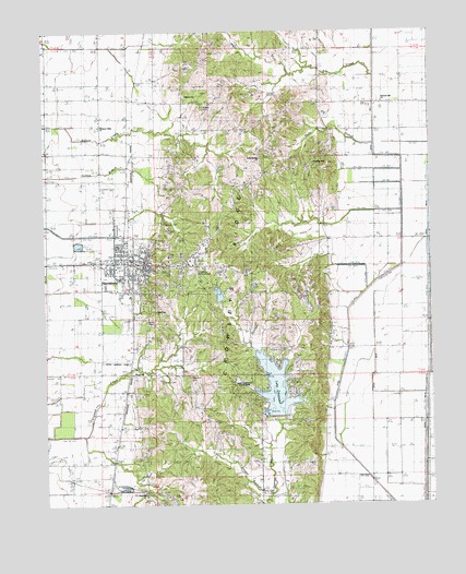
Harrisburg, AR USGS Topographic Map
Click on map above to begin viewing in our Map Viewer.

This topographic map contains these locations and features:
Feature Name Type Latitude Longitude GNIS ID View Map
Bay Road ChurchChurchN35.5079°W90.6601°46169View Map
Bethel CemeteryCemeteryN35.5323°W90.7132°77129View Map
Bethel ChurchChurchN35.5348°W90.7221°46456View Map
Bethel School (historical)SchoolN35.5351°W90.7279°82738View Map
Big CreekStreamN35.6129°W90.6440°46535View Map
Bolivar CemeteryCemeteryN35.6056°W90.6979°46821View Map
Bolivar ChurchChurchN35.6081°W90.7043°46822View Map
Bolivar School (historical)SchoolN35.5967°W90.7048°82739View Map
Burrow School (historical)SchoolN35.5948°W90.6604°82742View Map
City of HarrisburgCivilN35.5644°W90.7212°2403804View Map
Cooper BranchStreamN35.5029°W90.6776°48006View Map
Ditch Number 1CanalN35.6040°W90.6432°82024View Map
Ditch Number 2CanalN35.5776°W90.6429°82138View Map
Ditch Number 2aCanalN35.5840°W90.6432°82148View Map
Ditch Number 8CanalN35.5320°W90.6446°82394View Map
Ditch Number 83CanalN35.5954°W90.6337°82402View Map
Ditch Number 84CanalN35.5881°W90.6429°82403View Map
Farm Hill CemeteryCemeteryN35.5031°W90.7201°49006View Map
Farm Hill United Methodist ChurchChurchN35.5031°W90.7184°76909View Map
Harris CemeteryCemeteryN35.5487°W90.7171°65784View Map
HarrisburgPopulated PlaceN35.5642°W90.7168°77132View Map
Harrisburg Elementary SchoolSchoolN35.5540°W90.7251°2039113View Map
Harrisburg High SchoolSchoolN35.5636°W90.7264°82747View Map
Harrisburg Memorial ParkCemeteryN35.5626°W90.7012°77133View Map
Harrisburg Middle SchoolSchoolN35.5636°W90.7252°2039114View Map
Harrisburg Police DepartmentBuildingN35.5633°W90.7172°2118508View Map
Harrisburg Volunteer Fire StationBuildingN35.5632°W90.7158°2116536View Map
Holly Springs BranchStreamN35.5948°W90.6434°50241View Map
Holly Springs CemeteryCemeteryN35.5901°W90.6793°50247View Map
Holly Springs ChurchChurchN35.5912°W90.6798°65786View Map
Kingdom HallChurchN35.5901°W90.6626°65788View Map
Lake PoinsettReservoirN35.5311°W90.6757°80073View Map
Lake Poinsett DamDamN35.5234°W90.6734°80072View Map
Lake Poinsett State ParkParkN35.5320°W90.6868°65789View Map
Locust Grove School (historical)SchoolN35.6006°W90.7318°82751View Map
Mardis School (historical)SchoolN35.5142°W90.7282°82753View Map
Medic One HarrisburgBuildingN35.5604°W90.7246°2119131View Map
Missionary ChurchChurchN35.5512°W90.7143°65796View Map
New Hope Church (historical)ChurchN35.5295°W90.7326°82755View Map
Newsom CemeteryCemeteryN35.5340°W90.7029°52756View Map
Paul Senteny LakeReservoirN35.5601°W90.6934°80075View Map
Paul Senteny Lake DamDamN35.5601°W90.6934°80074View Map
Pecks Landing Strip (historical)AirportN35.5381°W90.7265°65803View Map
Pleasant Hill Baptist ChurchChurchN35.6067°W90.6409°78050View Map
Pleasant Hill Church (historical)ChurchN35.6023°W90.6601°82759View Map
Pleasant Valley United Methodist ChurchChurchN35.6001°W90.7329°82822View Map
Poinsett CountyCivilN35.5740°W90.6629°69174View Map
Poinsett County CourthouseBuildingN35.5631°W90.7173°65806View Map
Poinsett County Sheriff's OfficeBuildingN35.5801°W90.7159°2118509View Map
Poinsett Watershed Site 3 DamDamN35.5034°W90.6834°81242View Map
Poinsett Watershed Site Three ReservoirReservoirN35.5034°W90.6834°81243View Map
Ridgeview ChurchChurchN35.5454°W90.6332°54037View Map
Shiloh School (historical)SchoolN35.5120°W90.6812°82763View Map
Spencer CemeteryCemeteryN35.5745°W90.7115°55064View Map
Township of BolivarCivilN35.5781°W90.7156°68973View Map
Wayne Carter LakeReservoirN35.5451°W90.7184°80077View Map
Wayne Carter Lake DamDamN35.5451°W90.7184°80076View Map
WhitakerPopulated PlaceN35.5701°W90.6432°65818View Map
Whitaker SchoolSchoolN35.5706°W90.6418°56240View Map

Note: Coordinates in the location and feature list above are referenced to NAD83 datum.


Copyright (C) 2008-2024 Ryan Niemi / Sunset Dynamics ... All Rights Reserved