TopoQuest Logo
Do you find TopoQuest useful?
Help keep TopoQuest running and adding new maps/features by donating!
Bitcoin:  19c7KJd3qBynnjoSw5npx9KScwjBe4ifkT
Litecoin:  LXs6TkuXGGXo1vDsWCkWVdjQX94eUKd6ui
Home View Maps Find Maps Find Places Resources & Links


Greenville, Florida Topographic Map

USGS Map Title: Greenville, FL
USGS Map MRC: 30083D6
DRG (GeoTIFF) Download: o30083d6.tif


Neighboring USGS Topographic Map Quads:


  Monticello, FL  
30083E7
 

  Ashville, FL  
30083E6
 

  Hamburg, FL  
30083E5
 

  Lamont, FL  
30083D7
 

  Greenville, FL  
30083D6
 

  Greenville NE, FL  
30083D5
 

  Lamont SE, FL  
30083C7
 

  Shady Grove, FL  
30083C6
 

  Greenville SE, FL  
30083C5


Map MRC Location:

N31°
W84°
N31°
W83°
H8 H7 H6 H5 H4 H3 H2 H1
G8 G7 G6 G5 G4 G3 G2 G1
F8 F7 F6 F5 F4 F3 F2 F1
E8 E7 E6 E5 E4 E3 E2 E1
D8 D7 D6 D5 D4 D3 D2 D1
C8 C7 C6 C5 C4 C3 C2 C1
B8 B7 B6 B5 B4 B3 B2 B1
A8 A7 A6 A5 A4 A3 A2 A1
N30°
W84°
N30°
W83°

Greenville, FL USGS 1:24K Topographic Map Preview:
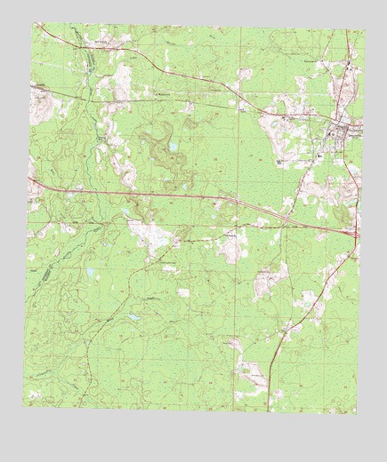
Greenville, FL USGS Topographic Map
Click on map above to begin viewing in our Map Viewer.

This topographic map contains these locations and features:
Feature Name Type Latitude Longitude GNIS ID View Map
Ahosulga (historical)Populated PlaceN30.4335°W83.6832°294558View Map
Andrews CemeteryCemeteryN30.3871°W83.6640°277871View Map
Aucilla Lookout TowerTowerN30.4230°W83.7002°277994View Map
Barclay CemeteryCemeteryN30.4210°W83.6593°278101View Map
Bishop CemeteryCemeteryN30.4424°W83.7485°278862View Map
Emery CemeteryCemeteryN30.4760°W83.7446°282199View Map
Flatwoods ChurchChurchN30.4899°W83.6424°282567View Map
GreenvillePopulated PlaceN30.4694°W83.6302°283426View Map
Greenville Baptist ChurchChurchN30.4674°W83.6299°2449261View Map
Greenville Middle SchoolSchoolN30.4585°W83.6407°298405View Map
Greenville Police DepartmentBuildingN30.4695°W83.6316°2333127View Map
Greenville Post OfficePost OfficeN30.4696°W83.6294°2783401View Map
Greenville Primary SchoolSchoolN30.4647°W83.6340°298406View Map
Greenville Public LibraryBuildingN30.4684°W83.6315°2449260View Map
Greenville Volunteer Fire DepartmentBuildingN30.4658°W83.6344°2644021View Map
Hensey CemeteryCemeteryN30.4796°W83.6813°283919View Map
Little Aucilla RiverStreamN30.4797°W83.7274°285585View Map
New Hopewell CemeteryCemeteryN30.4927°W83.6515°287649View Map
New Macedonia ChurchChurchN30.4035°W83.6496°300914View Map
New Mikasuki (historical)Populated PlaceN30.4835°W83.6499°294515View Map
New Zion ChurchChurchN30.4941°W83.7207°287705View Map
Porter CemeteryCemeteryN30.3977°W83.6718°289244View Map
Raysor CreekStreamN30.4138°W83.7457°289521View Map
ReamsPopulated PlaceN30.4860°W83.6274°300913View Map
Rocky CreekStreamN30.3866°W83.7385°289887View Map
Saint Mathews ChurchChurchN30.4777°W83.7029°290314View Map
Saint Paul ChurchChurchN30.4324°W83.6754°290332View Map
Shiloh Missionary Baptist ChurchChurchN30.4656°W83.6383°2449262View Map
SternPopulated PlaceN30.4669°W83.6415°302749View Map
Toponanaulka (historical)Populated PlaceN30.4502°W83.7165°294479View Map
Town of GreenvilleCivilN30.4668°W83.6353°2406616View Map
Wolf CreekStreamN30.4335°W83.7282°293461View Map

Note: Coordinates in the location and feature list above are referenced to NAD83 datum.


Copyright (C) 2008-2025 Ryan Niemi / Sunset Dynamics ... All Rights Reserved