TopoQuest Logo
Do you find TopoQuest useful?
Help keep TopoQuest running and adding new maps/features by donating!
Bitcoin:  19c7KJd3qBynnjoSw5npx9KScwjBe4ifkT
Litecoin:  LXs6TkuXGGXo1vDsWCkWVdjQX94eUKd6ui
Home View Maps Find Maps Find Places Resources & Links


Ashville, Florida Topographic Map

USGS Map Title: Ashville, FL
USGS Map MRC: 30083E6
DRG (GeoTIFF) Download: o30083e6.tif


Neighboring USGS Topographic Map Quads:


  Monticello NE, FL  
30083F7
 

  Grooverville, GA  
30083F6
 

  Baden, GA  
30083F5
 

  Monticello, FL  
30083E7
 

  Ashville, FL  
30083E6
 

  Hamburg, FL  
30083E5
 

  Lamont, FL  
30083D7
 

  Greenville, FL  
30083D6
 

  Greenville NE, FL  
30083D5


Map MRC Location:

N31°
W84°
N31°
W83°
H8 H7 H6 H5 H4 H3 H2 H1
G8 G7 G6 G5 G4 G3 G2 G1
F8 F7 F6 F5 F4 F3 F2 F1
E8 E7 E6 E5 E4 E3 E2 E1
D8 D7 D6 D5 D4 D3 D2 D1
C8 C7 C6 C5 C4 C3 C2 C1
B8 B7 B6 B5 B4 B3 B2 B1
A8 A7 A6 A5 A4 A3 A2 A1
N30°
W84°
N30°
W83°

Ashville, FL USGS 1:24K Topographic Map Preview:
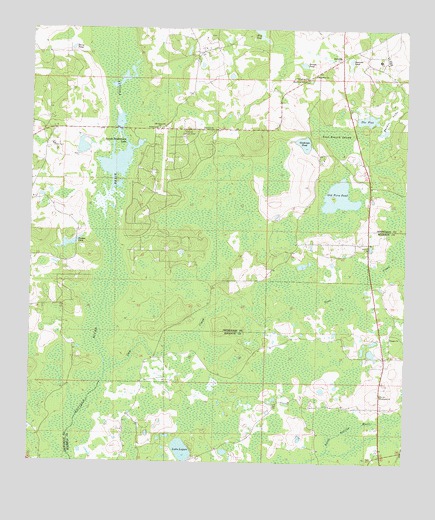
Ashville, FL USGS Topographic Map
Click on map above to begin viewing in our Map Viewer.

This topographic map contains these locations and features:
Feature Name Type Latitude Longitude GNIS ID View Map
Antioch ChurchChurchN30.5966°W83.6927°277913View Map
AshvillePopulated PlaceN30.6166°W83.6465°294660View Map
Ashville Lookout TowerTowerN30.5958°W83.6977°277971View Map
Bethel SchoolSchoolN30.5966°W83.7082°278557View Map
Blue PondLakeN30.6236°W83.6737°279055View Map
Brooks PondLakeN30.6150°W83.6596°279443View Map
Finlayson Farm AirportAirportN30.6159°W83.6524°309466View Map
Ginhouse PondLakeN30.5923°W83.6591°283094View Map
Gum CreekStreamN30.5255°W83.7249°283529View Map
Horse PondLakeN30.6196°W83.7362°284284View Map
Jefferson LandingsAirportN30.5791°W83.7066°309701View Map
Jerusalem ChurchChurchN30.6113°W83.6582°284774View Map
Lake LoganLakeN30.5037°W83.6987°285925View Map
Macedonia ChurchChurchN30.6105°W83.6593°286254View Map
Old Fern PondLakeN30.5771°W83.6473°288090View Map
Old Greenville ChurchChurchN30.5966°W83.7074°288096View Map
Parker PondLakeN30.5644°W83.7337°288519View Map
Pinckney Hill PondLakeN30.5871°W83.7265°298244View Map
Reaper ChurchChurchN30.5363°W83.6299°289525View Map
Reed Branch SwampSwampN30.5946°W83.6494°289590View Map
San Juan Ospalaga (historical)Populated PlaceN30.5085°W83.7332°294524View Map
Sanctified ChurchChurchN30.6119°W83.6557°290504View Map
Sessions PondLakeN30.6165°W83.6439°290862View Map
Shehee LakeLakeN30.5988°W83.6312°290966View Map
Sneads Smokehouse LakeLakeN30.5885°W83.7209°291300View Map
The FlatLakeN30.5994°W83.6382°292157View Map
Wesleyan ChurchChurchN30.5194°W83.6327°293028View Map

Note: Coordinates in the location and feature list above are referenced to NAD83 datum.


Copyright (C) 2008-2024 Ryan Niemi / Sunset Dynamics ... All Rights Reserved