TopoQuest Logo
Do you find TopoQuest useful?
Help keep TopoQuest running and adding new maps/features by donating!
Bitcoin:  19c7KJd3qBynnjoSw5npx9KScwjBe4ifkT
Litecoin:  LXs6TkuXGGXo1vDsWCkWVdjQX94eUKd6ui
Home View Maps Find Maps Find Places Resources & Links


Lamont, Florida Topographic Map

USGS Map Title: Lamont, FL
USGS Map MRC: 30083D7
DRG (GeoTIFF) Download: o30083d7.tif


Neighboring USGS Topographic Map Quads:


  Lake Miccosukee, FL  
30083E8
 

  Monticello, FL  
30083E7
 

  Ashville, FL  
30083E6
 

  Waukeenah, FL  
30083D8
 

  Lamont, FL  
30083D7
 

  Greenville, FL  
30083D6
 

  Wacissa, FL  
30083C8
 

  Lamont SE, FL  
30083C7
 

  Shady Grove, FL  
30083C6


Map MRC Location:

N31°
W84°
N31°
W83°
H8 H7 H6 H5 H4 H3 H2 H1
G8 G7 G6 G5 G4 G3 G2 G1
F8 F7 F6 F5 F4 F3 F2 F1
E8 E7 E6 E5 E4 E3 E2 E1
D8 D7 D6 D5 D4 D3 D2 D1
C8 C7 C6 C5 C4 C3 C2 C1
B8 B7 B6 B5 B4 B3 B2 B1
A8 A7 A6 A5 A4 A3 A2 A1
N30°
W84°
N30°
W83°

Lamont, FL USGS 1:24K Topographic Map Preview:
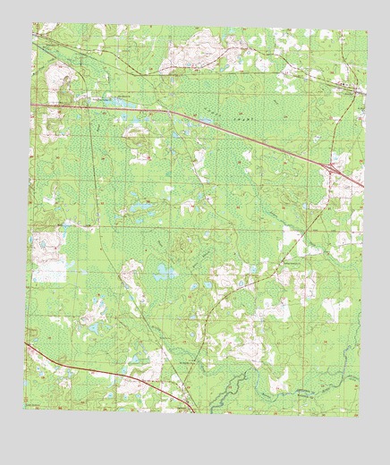
Lamont, FL USGS Topographic Map
Click on map above to begin viewing in our Map Viewer.

This topographic map contains these locations and features:
Feature Name Type Latitude Longitude GNIS ID View Map
Alligator CreekStreamN30.3869°W83.7565°277789View Map
Anderson CemeteryCemeteryN30.3752°W83.8274°277856View Map
AucillaPopulated PlaceN30.4799°W83.7543°277993View Map
Aucilla (historical)Populated PlaceN30.4169°W83.7665°294562View Map
Aucilla Census Designated PlaceCensusN30.4770°W83.7604°2628518View Map
Beasley CreekStreamN30.3819°W83.7988°278352View Map
Buggs CreekStreamN30.4191°W83.8174°279630View Map
Dixie BranchStreamN30.4191°W83.8174°281604View Map
Drifton BranchStreamN30.4899°W83.8643°281766View Map
Edmond Doyles GrantCivilN30.3771°W83.8521°300046View Map
Friendship ChurchChurchN30.4935°W83.8677°282825View Map
Gress SwampSwampN30.4745°W83.7993°283439View Map
LamontPopulated PlaceN30.3772°W83.8129°285320View Map
Lamont Census Designated PlaceCensusN30.3797°W83.8134°2628525View Map
Lamont Post OfficePost OfficeN30.3781°W83.8144°2783373View Map
Mill Pond CreekStreamN30.4896°W83.8643°286901View Map
Mount Marille CemeteryCemeteryN30.3988°W83.8243°287231View Map
Mount Marille ChurchChurchN30.3910°W83.8113°287232View Map
Sanctified ChurchChurchN30.4763°W83.8424°290503View Map
Scruggs CemeteryCemeteryN30.4908°W83.8113°290776View Map
Thompson Valley ChurchChurchN30.4763°W83.8449°292231View Map
Turkey Scratch ChurchChurchN30.4247°W83.7793°292545View Map
Turkey Scratch Plantation AirportAirportN30.4074°W83.8108°2676667View Map

Note: Coordinates in the location and feature list above are referenced to NAD83 datum.


Copyright (C) 2008-2025 Ryan Niemi / Sunset Dynamics ... All Rights Reserved